Tocht Stappen Trespoux-Rassiels - Trespoux (circuit) - Photo
 poupartbertrand
poupartbertrand

Gebruiker

© OpenStreetMap contributors
Lengte
Lengte
11,7 km
Max. hoogte
Max. hoogte
332 m
Positief hoogteverschil
258 m
Km-Effort
Km-Effort  
15,1 km
Min. hoogte
Min. hoogte
156 m
Negatief hoogteverschil
253 m
Boucle
Boucle
Ja
Datum van aanmaak :
2014-12-10 00:00:00.0
Laatste wijziging :
2014-12-10 00:00:00.0

(0 Bericht)

Stappen
Stappen
2h00
Moeilijkheid : Medium

Scan deze QR-code om de tocht te openen in de SityTrail-applicatie

Gratisgps-wandelapplicatie

Logo SityTrail SityTrail

IGN / Geografische instituten

SityTrail uit de App Store downloaden SityTrail uit Google Play downloaden

Logo SityTrail SityTrail World

De wereld gaat voor u open

SityTrail uit de App Store downloaden SityTrail uit Google Play downloaden SityTrail op Huawei AppGallery downloaden

Over ons

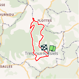
Tocht Stappen van 11,7 km beschikbaar op Occitanië, Lot, Trespoux-Rassiels. Deze tocht wordt voorgesteld door poupartbertrand.

Beschrijving

BALISAGE JAUNE
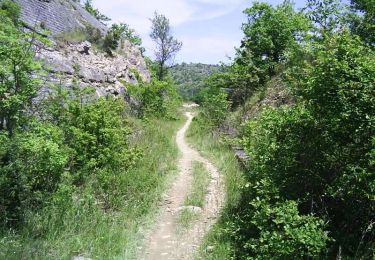
Pas de difficulté particulière. Alternance de marche à découvert et en sous-bois.
Départ depuis l'église de Trespoux.
         

Hoogteprofiel

Plaatsbepaling

Land:
France
Regio :
Occitanië
Departement/Provincie :
Lot
Gemeente :
Trespoux-Rassiels
Locatie:
Unknown
Vertrek:(Dec)
Vertrek:(UTM)
370850 ; 4918895 (31T) N.

Wandeltochten in de omgeving

Tocht Mountainbike Cahors - Cahors-La Rozière 2005 - Photo
Mountainbike
tracegps

Mountainbike

Zeer moeilijk
(1)
Cahors, Occitanië, Lot, France
62 km | 81 km-effort
5h 0min
Ja
Tocht Stappen Pradines - Cahors les Durands 7km - Photo
Stappen
PariseJL

Stappen

Gemakkelijk
(1)
Pradines, Occitanië, Lot, France
7,1 km | 9,3 km-effort
2h 13min
Ja
Tocht Stappen Cahors - Croix magne  - Photo
Stappen
GUIDE
antignacs

Stappen

Heel gemakkelijk
Cahors, Occitanië, Lot, France
5,2 km | 7,2 km-effort
1h 20min
Neen
Tocht Stappen Cahors - Étape Cahors Lascabannes  - Photo
Stappen
Jean-MarieFaux

Stappen

Gemakkelijk
Cahors, Occitanië, Lot, France
23 km | 30 km-effort
18h 50min
Neen
Tocht Stappen Labastide-Marnhac - Mon Compostelle huitième étape - Photo
Stappen
Ardeiserois

Stappen

Moeilijk
Labastide-Marnhac, Occitanië, Lot, France
51 km | 65 km-effort
10h 40min
Neen
Tocht Mountainbike Trespoux-Rassiels - Circuit ouest de Trespoux Rassiels - Photo
Mountainbike
tracegps

Mountainbike

Zeer moeilijk
Trespoux-Rassiels, Occitanië, Lot, France
38 km | 51 km-effort
4h 15min
Ja
Tocht Lopen Cahors - Cahors, le Lot, le causse, la vieille ville - Photo
Lopen
tracegps

Lopen

Medium
Cahors, Occitanië, Lot, France
7,3 km | 10 km-effort
45min
Ja
Tocht Stappen Cahors - Cahors, le Lot, le causse, la vieille ville - Photo
Stappen
tracegps

Stappen

Medium
Cahors, Occitanië, Lot, France
7,3 km | 10 km-effort
1h 30min
Ja
Tocht Mountainbike Cahors - Raid Cahors La Rozière 2006 - Photo
Mountainbike
tracegps

Mountainbike

Zeer moeilijk
Cahors, Occitanië, Lot, France
59 km | 78 km-effort
4h 40min
Ja


Sluiten
Mijn abonnementen