Tocht Stappen Laval-de-Cère - Les cascades perdues - Photo

Les cascades perdues

 neleda
neleda

Gebruiker

© OpenStreetMap contributors
Lengte
Lengte
13,5 km
Max. hoogte
Max. hoogte
431 m
Positief hoogteverschil
475 m
Km-Effort
Km-Effort  
19,8 km
Min. hoogte
Min. hoogte
160 m
Negatief hoogteverschil
475 m
Boucle
Boucle
Ja
Datum van aanmaak :
2019-05-07 02:13:33.519
Laatste wijziging :
2019-05-07 02:13:33.519

(1 Bericht)

Stappen
Stappen
5h08
Moeilijkheid : Gemakkelijk

Scan deze QR-code om de tocht te openen in de SityTrail-applicatie

Gratisgps-wandelapplicatie

Logo SityTrail SityTrail

IGN / Geografische instituten

SityTrail uit de App Store downloaden SityTrail uit Google Play downloaden

Logo SityTrail SityTrail World

De wereld gaat voor u open

SityTrail uit de App Store downloaden SityTrail uit Google Play downloaden SityTrail op Huawei AppGallery downloaden

Over ons

Tocht Stappen van 13,5 km beschikbaar op Occitanië, Lot, Laval-de-Cère. Deze tocht wordt voorgesteld door neleda.

Hoogteprofiel

Foto's

POI's

POI Laval-de-Cère - Château Laborie - Photo
neleda
LAVAL-DE-CÈRE 
POI Laval-de-Cère - Rhododrendrons - Photo
neleda
LAVAL-DE-CÈRE 
POI Laval-de-Cère - Cascade 2 - Photo
neleda
LAVAL-DE-CÈRE 
POI Laval-de-Cère - La vie au grand air - Photo
neleda
LAVAL-DE-CÈRE 
POI Gagnac-sur-Cère - Point 9 - Photo
neleda
GAGNAC-SUR-CÈRE 

Plaatsbepaling

Land:
France
Regio :
Occitanië
Departement/Provincie :
Lot
Gemeente :
Laval-de-Cère
Locatie:
Unknown
Vertrek:(Dec)
Vertrek:(UTM)
416089 ; 4978323 (31T) N.

Opmerkingen

Gelieve in te loggen om een commentaar of een beoordeling achter te laten


août 2019-belle ballade dans une forêt naturelle cadre superbe. balisage jaune 12 sur tout le parcours. je classe dans 'moyen' cf longueur et dénivelé.


Wandeltochten in de omgeving

Tocht Stappen Camps-Saint-Mathurin-Léobazel - Camps - Mercoeur - Photo
Stappen
houbart

Stappen

Moeilijk
(1)
Camps-Saint-Mathurin-Léobazel, Nieuw-Aquitanië, Corrèze, France
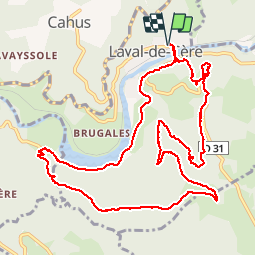
14 km | 17,5 km-effort
3h 58min
Ja
Tocht Stappen Camps-Saint-Mathurin-Léobazel - La Via Arverna (Camps-Saint-Mathurin - Bretenoux) - Photo
Stappen
tracegps

Stappen

Moeilijk
(1)
Camps-Saint-Mathurin-Léobazel, Nieuw-Aquitanië, Corrèze, France
29 km | 39 km-effort
8h 0min
Neen
Tocht Stappen Teyssieu - Teyssieu - Photo
Stappen
Gaillard Isabelle

Stappen

Medium
Teyssieu, Occitanië, Lot, France
17,5 km | 24 km-effort
5h 30min
Ja
Tocht Stappen Camps-Saint-Mathurin-Léobazel - de Camps St Mathurin à Laval de Cere - Photo
Stappen
neleda

Stappen

Medium
Camps-Saint-Mathurin-Léobazel, Nieuw-Aquitanië, Corrèze, France
20 km | 30 km-effort
6h 37min
Neen
Tocht Mountainbike Cornac - Biars 27km-6884037 - Photo
Mountainbike
Gpoujade

Mountainbike

Moeilijk
Cornac, Occitanië, Lot, France
28 km | 39 km-effort
2h 42min
Ja
Tocht Mountainbike Cornac - RANDO BRETENOUX 75 KM-3035703 - Photo
Mountainbike
Gpoujade

Mountainbike

Moeilijk
Cornac, Occitanië, Lot, France
29 km | 41 km-effort
2h 50min
Ja
Tocht Mountainbike Teyssieu - SityTrail - 4x4 gorges de la cère - Photo
Mountainbike
Gpoujade

Mountainbike

Zeer moeilijk
Teyssieu, Occitanië, Lot, France
37 km | 51 km-effort
3h 31min
Ja
Tocht Stappen Glanes - randogps46-194 - Photo
Stappen
houbart

Stappen

Moeilijk
Glanes, Occitanië, Lot, France
14,6 km | 18,4 km-effort
4h 11min
Ja
Tocht Auto Gagnac-sur-Cère - 28 juin 2020 - Photo
Auto
alain46

Auto

Medium
Gagnac-sur-Cère, Occitanië, Lot, France
78 km | 101 km-effort
1h 36min
Neen


Sluiten
Mijn abonnementen