Tocht Fiets Jaulny - La vallée du Rupt de Mad - Circuit n° 14 - Jaulny - Photo

La vallée du Rupt de Mad - Circuit n° 14 - Jaulny

 tracegps
tracegps

Gebruiker

© OpenStreetMap contributors
Lengte
Lengte
19,1 km
Max. hoogte
Max. hoogte
265 m
Positief hoogteverschil
238 m
Km-Effort
Km-Effort  
22 km
Min. hoogte
Min. hoogte
187 m
Negatief hoogteverschil
238 m
Boucle
Boucle
Ja
Datum van aanmaak :
2014-12-10 00:00:00.0
Laatste wijziging :
2014-12-10 00:00:00.0

(0 Bericht)

Fiets
Fiets
1h00
Moeilijkheid : Gemakkelijk

Scan deze QR-code om de tocht te openen in de SityTrail-applicatie

Gratisgps-wandelapplicatie

Logo SityTrail SityTrail

IGN / Geografische instituten

SityTrail uit de App Store downloaden SityTrail uit Google Play downloaden

Logo SityTrail SityTrail World

De wereld gaat voor u open

SityTrail uit de App Store downloaden SityTrail uit Google Play downloaden SityTrail op Huawei AppGallery downloaden

Over ons

Tocht Fiets van 19,1 km beschikbaar op Grand Est, Meurthe-et-Moselle, Jaulny. Deze tocht wordt voorgesteld door tracegps.

Beschrijving

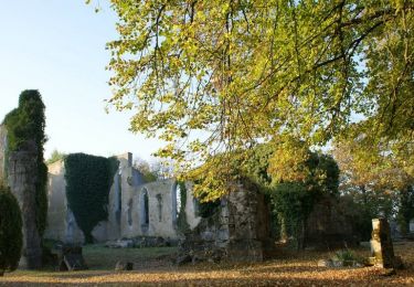
Depuis les hauteurs jusqu’au lit de la rivière, un itinéraire pour découvrir la vallée du Rupt de Mad, territoire champêtre et verdoyant du Parc Naturel Régional de Lorraine. Départ de Jaulny. Retrouvez ici le plan et descriptif du circuit. Vous pouvez obtenir le guide par courrier auprés du Parc Naturel Régional de Lorraine.

Hoogteprofiel

Foto's

Plaatsbepaling

Land:
France
Regio :
Grand Est
Departement/Provincie :
Meurthe-et-Moselle
Gemeente :
Jaulny
Locatie:
Unknown
Vertrek:(Dec)
Vertrek:(UTM)
711298 ; 5428186 (31U) N.

Wandeltochten in de omgeving

Tocht Fiets Thiaucourt-Regniéville - Les paysages de l'Histoire (option Flirey) - Circuit n° 13 - Photo
Fiets
tracegps

Fiets

Moeilijk
Thiaucourt-Regniéville, Grand Est, Meurthe-et-Moselle, France
60 km | 68 km-effort
3h 0min
Ja
Tocht Fiets Thiaucourt-Regniéville - Les paysages de l'Histoire - Circuit n° 13 - Thiaucourt Regniéville - Photo
Fiets
tracegps

Fiets

Medium
Thiaucourt-Regniéville, Grand Est, Meurthe-et-Moselle, France
49 km | 56 km-effort
2h 30min
Ja
Tocht Mountainbike Thiaucourt-Regniéville - Thiaucourt Jaulny Rembercourt - Photo
Mountainbike
kikkko

Mountainbike

Gemakkelijk
Thiaucourt-Regniéville, Grand Est, Meurthe-et-Moselle, France
16,9 km | 21 km-effort
1h 36min
Ja
Tocht Stappen Viéville-en-Haye - circuit des Rappes - Photo
Stappen
kikkko

Stappen

Gemakkelijk
Viéville-en-Haye, Grand Est, Meurthe-et-Moselle, France
13,6 km | 16,2 km-effort
2h 33min
Neen
Tocht Mountainbike Rembercourt-sur-Mad - rembercourt/thiaucourt/AR - Photo
Mountainbike
PascalKvtt

Mountainbike

Medium
Rembercourt-sur-Mad, Grand Est, Meurthe-et-Moselle, France
19,7 km | 25 km-effort
2h 29min
Ja
Tocht Mountainbike Thiaucourt-Regniéville - sortie de thaucourd ctm - Photo
Mountainbike
nouga

Mountainbike

Moeilijk
Thiaucourt-Regniéville, Grand Est, Meurthe-et-Moselle, France
26 km | 31 km-effort
2h 30min
Ja
Tocht Stappen Thiaucourt-Regniéville - Thiaucourt Bouillonville - Photo
Stappen
kikkko

Stappen

Gemakkelijk
Thiaucourt-Regniéville, Grand Est, Meurthe-et-Moselle, France
9,7 km | 11,7 km-effort
2h 23min
Ja
Tocht Mountainbike Thiaucourt-Regniéville - EC CTM THIAUCOURT 1 - Photo
Mountainbike
PascalKvtt

Mountainbike

Gemakkelijk
Thiaucourt-Regniéville, Grand Est, Meurthe-et-Moselle, France
16,9 km | 21 km-effort
1h 22min
Neen
Tocht Stappen Vilcey-sur-Trey - Vilcey-sur-Trey - Photo
Stappen
grandville

Stappen

Moeilijk
Vilcey-sur-Trey, Grand Est, Meurthe-et-Moselle, France
15,2 km | 18,7 km-effort
4h 6min
Ja


Sluiten
Mijn abonnementen