Trail Walking Gémenos - autour du petit tuny  - Photo
© OpenStreetMap contributors
Length
Length
9.1 km
Max alt
Max alt
551 m
Uphill gradient
Uphill gradient
419 m
Km-Effort
Km-Effort  
14.7 km
Min alt
Min alt
169 m
Downhill gradient
Downhill gradient
419 m
Boucle
Boucle
Yes
Creation date :
2017-02-23 00:00:00.0
Updated on :
2017-02-23 00:00:00.0

(0 Reviews)

Walking
Walking
2h58
Difficulty : Unknown

Scan this QR Code to open this trail in the SityTrail application

FREE GPS app for hiking

Logo SityTrail SityTrail

IGN / Geographical institutes

Download SityTrail from the App Store Download SityTrail from Google Play

Logo SityTrail SityTrail World

The world is yours!

Download SityTrail from the App Store Download SityTrail from Google Play Download SityTrail on Huawei AppGallery

About

Trail Walking of 9.1 km to be discovered at Provence-Alpes-Côte d'Azur, Bouches-du-Rhône, Gémenos. This trail is proposed by Coryphene.

Description

de Saint Jean de garguier au petit tuny

Elevation profile

Photos

Positioning

Country:
France
Region :
Provence-Alpes-Côte d'Azur
Department/Province :
Bouches-du-Rhône
Municipality :
Gémenos
Location:
Unknown
Start:(UTM)
711823 ; 4798948 (31T) N.

Trails nearby

Trail Walking Gémenos - St Pons Le Fauge Glacière  - Photo
Walking
GUIDE
lhomme.ph

Walking

Difficult
(1)
Gémenos, Provence-Alpes-Côte d'Azur, Bouches-du-Rhône, France
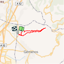
11.7 km | 18.6 km-effort
3h 56min
Yes
Trail Walking Gémenos - dent de roque forcade. cauvin.bertagne. 2 avril 2018 - Photo
Walking
marchev

Walking

Medium
(1)
Gémenos, Provence-Alpes-Côte d'Azur, Bouches-du-Rhône, France
12.7 km | 20 km-effort
4h 31min
Yes
Trail Walking Auriol - la crete des infernets - Photo
Walking
Coryphene

Walking

Difficult
(1)
Auriol, Provence-Alpes-Côte d'Azur, Bouches-du-Rhône, France
8.6 km | 14 km-effort
3h 22min
Yes
Trail Walking Gémenos - autour de Saint pons - Photo
Walking
Coryphene

Walking

Easy
(1)
Gémenos, Provence-Alpes-Côte d'Azur, Bouches-du-Rhône, France
11.6 km | 16.1 km-effort
3h 46min
Yes
Trail Walking Gémenos - Autour des Dents de Roque Forcade, Tour de Cauvin - Photo
Walking
tracegps

Walking

Difficult
(1)
Gémenos, Provence-Alpes-Côte d'Azur, Bouches-du-Rhône, France
7.6 km | 11.7 km-effort
3h 15min
Yes
Trail Mountain bike Gémenos - Gémenos - La Grande Baume - Photo
Mountain bike
tracegps

Mountain bike

Difficult
(1)
Gémenos, Provence-Alpes-Côte d'Azur, Bouches-du-Rhône, France
18.4 km | 29 km-effort
3h 30min
Yes
Trail Walking Auriol - le ravin des Encanaux - Photo
Walking
GUIDE
amiral13

Walking

Difficult
Auriol, Provence-Alpes-Côte d'Azur, Bouches-du-Rhône, France
7.3 km | 12.2 km-effort
3h 10min
Yes
Trail On foot Aubagne - la coueste de moi - Photo
On foot
Coryphene

On foot

Easy
(1)
Aubagne, Provence-Alpes-Côte d'Azur, Bouches-du-Rhône, France
8.7 km | 12.5 km-effort
Unknown
Yes
Trail Walking Roquevaire - Garlaban au départ de Lascours  - Photo
Walking
GUIDE
nadinebondoux

Walking

Difficult
Roquevaire, Provence-Alpes-Côte d'Azur, Bouches-du-Rhône, France
15.6 km | 26 km-effort
6h 1min
Yes


Close
My subscriptions