![](/images/other/stat-length.png)
![Randonnée Marche Cases-de-Pène - RP66 CASES DE PÊNE - tour del far - Photo](https://media.geolcdn.com/t/1900/400/ext.pjpeg?maxdim=2&url=https%3A%2F%2Fstatic1.geolcdn.com%2Fsiteimages%2Fupload%2Ffiles%2F1553511878bg_sport_marche.png)
RP66 CASES DE PÊNE - tour del far
jeff66
Utilisateur
![Longueur](/images/other/stat-length.png)
Longueur
8,7 km
![Altitude max](https://static1.geolcdn.com/siteimages/upload/files/1508320355ic_sort_altitude_max_24dp.png)
Altitude max
481 m
![Dénivelé positif](https://static1.geolcdn.com/siteimages/upload/files/1508320355ic_sort_den_pos_24dp.png)
Dénivelé positif
438 m
![Km-Effort](/images/other/stat-length.png)
Km-Effort
14,5 km
![Altitude min](https://static1.geolcdn.com/siteimages/upload/files/1508320355ic_sort_altitude_min_24dp.png)
Altitude min
51 m
![Dénivelé négatif](https://static1.geolcdn.com/siteimages/upload/files/1508320355ic_sort_den_neg_24dp.png)
Dénivelé négatif
438 m
![Boucle](https://static1.geolcdn.com/siteimages/upload/files/16400158638029165_repeat_loop_refresh_sync_direction_icon.png)
Boucle
Oui
Date de création :
2017-04-11 00:00:00.0
Dernière modification :
2017-04-11 00:00:00.0
![Marche](https://static1.geolcdn.com/sitytour/trail-icons/101.png)
2h17
Difficulté : Moyen
![Scannez ce code QR pour ouvrir la randonnée dans l'application SityTrail](https://capi.geolives.com/qq0zvz2zws4bq2lad0pu/sitytour/trails/731044/qr.png?size=200)
Application GPS de randonnée GRATUITE
À propos
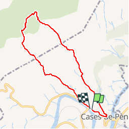
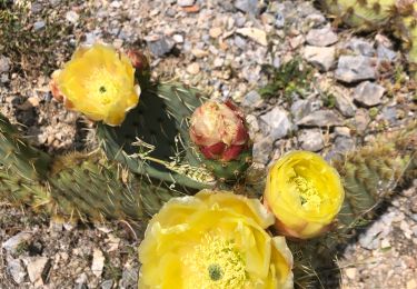
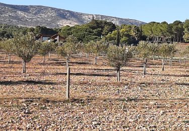
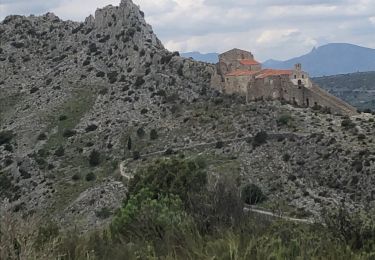
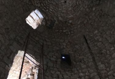
Randonnée Marche de 8,7 km à découvrir à Occitanie, Pyrénées-Orientales, Cases-de-Pène. Cette randonnée est proposée par jeff66.
Description
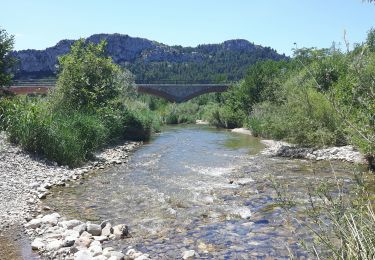
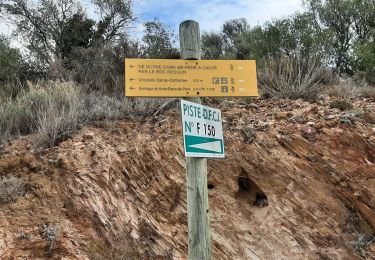
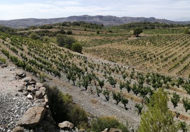
RP66 CASES DE PÊNE - route de Tautavel - piste DFCI C17 - ravin de Badeilla - le camp gras - Collada D'en Gilbert - Serrat de Trenque Bouteils - tour del far - coma d'en Finestre - jasse d'en Dosset - coume d'en Roc - RD59 - le 11.04.2017
Localisation
Pays :
France
Région :
Occitanie
Département/Province :
Pyrénées-Orientales
Commune :
Cases-de-Pène
Localité :
Unknown
Départ:(Dec)
Départ:(UTM)
482093 ; 4736560 (31T) N.
Commentaires
Randonnées à proximité
![Randonnée Marche Tautavel - Tautavel chemin des bacs - Photo](https://media.geolcdn.com/t/375/260/ext.jpg?maxdim=2&url=https%3A%2F%2Fmedia.geolcdn.com%2Ff%2F4347d338-087b-4ab9-a23d-b90780ad37c2.jpg)
![Marche Marche](https://static1.geolcdn.com/sitytour/trail-icons/101.png)
Tautavel chemin des bacs
Marche
Facile
(3)
Tautavel,
Occitanie,
Pyrénées-Orientales,
France
![](/images/other/stat-length.png)
9,5 km | 12,4 km-effort
2h 30min
![](https://static1.geolcdn.com/siteimages/upload/files/16400158638029165_repeat_loop_refresh_sync_direction_icon.png)
Oui
![Randonnée Marche Cases-de-Pène - Hermitage de case de pène, le 11 août 2013 - Photo](https://media.geolcdn.com/t/375/260/ext.jpg?maxdim=2&url=https%3A%2F%2Fstatic1.geolcdn.com%2Fsiteimages%2Fupload%2Ffiles%2F1553511878bg_sport_marche.png)
![Marche Marche](https://static1.geolcdn.com/sitytour/trail-icons/101.png)
Hermitage de case de pène, le 11 août 2013
Marche
Difficile
(2)
Cases-de-Pène,
Occitanie,
Pyrénées-Orientales,
France
![](/images/other/stat-length.png)
7,4 km | 11,5 km-effort
1h 55min
![](https://static1.geolcdn.com/siteimages/upload/files/16400158638029165_repeat_loop_refresh_sync_direction_icon.png)
Oui
![Randonnée Marche Baixas - baixas chapelle ste catherine - Photo](https://media.geolcdn.com/t/375/260/ext.jpg?maxdim=2&url=https%3A%2F%2Fmedia.geolcdn.com%2Ff%2Fd3b7c9c4-76b1-42bc-afd1-f1141b6126a7.jpg)
![Marche Marche](https://static1.geolcdn.com/sitytour/trail-icons/101.png)
baixas chapelle ste catherine
Marche
Difficile
Baixas,
Occitanie,
Pyrénées-Orientales,
France
![](/images/other/stat-length.png)
9,5 km | 12,9 km-effort
3h 56min
![](https://static1.geolcdn.com/siteimages/upload/files/16400158638029165_repeat_loop_refresh_sync_direction_icon.png)
Oui
![Randonnée Marche Cases-de-Pène - 2023-08-01_12h04m36_SityTrail - 3754591 - Cases-de-Pene-x-detour-et-retour - Photo](https://media.geolcdn.com/t/375/260/ext.jpg?maxdim=2&url=https%3A%2F%2Fmedia.geolcdn.com%2Ff%2F883a1714-3990-4d53-92ac-a82da8ee9827.jpg)
![Marche Marche](https://static1.geolcdn.com/sitytour/trail-icons/101.png)
2023-08-01_12h04m36_SityTrail - 3754591 - Cases-de-Pene-x-detour-et-retour
Marche
Moyen
Cases-de-Pène,
Occitanie,
Pyrénées-Orientales,
France
![](/images/other/stat-length.png)
5 km | 6,1 km-effort
1h 23min
![](https://static1.geolcdn.com/siteimages/upload/files/16400158638029165_repeat_loop_refresh_sync_direction_icon.png)
Oui
![Randonnée Marche Cases-de-Pène - 20230528 Nostradamus Seynora de Pene - Photo](https://media.geolcdn.com/t/375/260/ext.jpg?maxdim=2&url=https%3A%2F%2Fmedia.geolcdn.com%2Ff%2F8ec76a99-d504-40dd-9657-2c438f447ce5.jpg)
![Marche Marche](https://static1.geolcdn.com/sitytour/trail-icons/101.png)
20230528 Nostradamus Seynora de Pene
Marche
Moyen
Cases-de-Pène,
Occitanie,
Pyrénées-Orientales,
France
![](/images/other/stat-length.png)
15,3 km | 22 km-effort
4h 5min
![](https://static1.geolcdn.com/siteimages/upload/files/16400158638029165_repeat_loop_refresh_sync_direction_icon.png)
Oui
![Randonnée Marche Espira-de-l'Agly - espira montpins - Photo](https://media.geolcdn.com/t/375/260/ext.jpg?maxdim=2&url=https%3A%2F%2Fmedia.geolcdn.com%2Ff%2Fa49b025a-ead8-4ed6-b68b-909149e1220d.jpg)
![Marche Marche](https://static1.geolcdn.com/sitytour/trail-icons/101.png)
espira montpins
Marche
Moyen
Espira-de-l'Agly,
Occitanie,
Pyrénées-Orientales,
France
![](/images/other/stat-length.png)
9,2 km | 11,3 km-effort
2h 48min
![](https://static1.geolcdn.com/siteimages/upload/files/16400158638029165_repeat_loop_refresh_sync_direction_icon.png)
Oui
![Randonnée Marche Cases-de-Pène - 20220419 Ermitage Cases-de-Pene - Photo](https://media.geolcdn.com/t/375/260/ext.jpg?maxdim=2&url=https%3A%2F%2Fmedia.geolcdn.com%2Ff%2Fd51772c3-7cce-4e42-801a-cc23a8ec9c89.jpg)
![Marche Marche](https://static1.geolcdn.com/sitytour/trail-icons/101.png)
20220419 Ermitage Cases-de-Pene
Marche
Moyen
Cases-de-Pène,
Occitanie,
Pyrénées-Orientales,
France
![](/images/other/stat-length.png)
15,2 km | 22 km-effort
3h 42min
![](https://static1.geolcdn.com/siteimages/upload/files/16400158638029165_repeat_loop_refresh_sync_direction_icon.png)
Oui
![Randonnée Marche Tautavel - TAUTAVEL la Tour del Far A/R - Photo](https://media.geolcdn.com/t/375/260/ext.jpg?maxdim=2&url=https%3A%2F%2Fmedia.geolcdn.com%2Ff%2F7315cb9e-35b2-46c7-8732-adf6f85e9975.jpg)
![Marche Marche](https://static1.geolcdn.com/sitytour/trail-icons/101.png)
TAUTAVEL la Tour del Far A/R
Marche
Moyen
Tautavel,
Occitanie,
Pyrénées-Orientales,
France
![](/images/other/stat-length.png)
6,3 km | 11,4 km-effort
3h 55min
![](https://static1.geolcdn.com/siteimages/upload/files/16400158638029165_repeat_loop_refresh_sync_direction_icon.png)
Oui
![Randonnée Marche Tautavel - Tautavel -Torre del Far - Photo](https://media.geolcdn.com/t/375/260/ext.jpg?maxdim=2&url=https%3A%2F%2Fmedia.geolcdn.com%2Ff%2Ff1e44f1c-1dc1-496a-9f67-a9c732e79842.jpg)
![Marche Marche](https://static1.geolcdn.com/sitytour/trail-icons/101.png)
Tautavel -Torre del Far
Marche
Moyen
(1)
Tautavel,
Occitanie,
Pyrénées-Orientales,
France
![](/images/other/stat-length.png)
9,5 km | 15,4 km-effort
3h 1min
![](https://static1.geolcdn.com/siteimages/upload/files/16400158638029165_repeat_loop_refresh_sync_direction_icon.png)
Oui