Randonnée Marche Biaches - Circuit de Biaches / Flaucourt - Photo

Circuit de Biaches / Flaucourt

 corsinou
corsinou

Utilisateur

© OpenStreetMap contributors
Longueur
Longueur
12,9 km
Altitude max
Altitude max
94 m
Dénivelé positif
Dénivelé positif
97 m
Km-Effort
Km-Effort  
14,2 km
Altitude min
Altitude min
48 m
Dénivelé négatif
Dénivelé négatif
96 m
Boucle
Boucle
Oui
Date de création :
2015-04-08 00:00:00.0
Dernière modification :
2015-04-08 00:00:00.0

(0 Avis)

Marche
Marche
3h09
Difficulté : Facile

Scannez ce code QR pour ouvrir la randonnée dans l'application SityTrail

Application GPS de randonnée GRATUITE

Logo SityTrail SityTrail

IGN / Instituts géographiques

Télécharger SityTrail sur l'App Store Télécharger SityTrail sur Google Play

Logo SityTrail SityTrail World

Le monde est à vous

Télécharger SityTrail sur l'App Store Télécharger SityTrail sur Google Play Télécharger SityTrail sur Huawei AppGallery

À propos

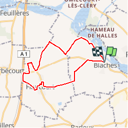
Randonnée Marche de 12,9 km à découvrir à Hauts-de-France, Somme, Biaches. Cette randonnée est proposée par corsinou.

Description

Ce circuit au départ de Biaches, longe le canal de la somme pour se diriger vers le bois de l'épée, puis le sole de Cléry , d'Herbecourt,  des Baraquins pour rejoindre Flaucourt et le bois de Marc pour revenir à Biaches

Profil altimétrique

Points d'intérêt

Point d'intérêt Biaches - . - Photo
corsinou
BIACHES 
Point d'intérêt Biaches - . - Photo
corsinou
BIACHES 
Point d'intérêt Biaches - . - Photo
corsinou
BIACHES 
Point d'intérêt Flaucourt - . - Photo
corsinou
FLAUCOURT 
Point d'intérêt Flaucourt - . - Photo
corsinou
FLAUCOURT 
Point d'intérêt Flaucourt - . - Photo
corsinou
FLAUCOURT 
Point d'intérêt Flaucourt - . - Photo
corsinou
FLAUCOURT 
Point d'intérêt Flaucourt - . - Photo
corsinou
FLAUCOURT 
Point d'intérêt Flaucourt - . - Photo
corsinou
FLAUCOURT 
Point d'intérêt Flaucourt - . - Photo
corsinou
FLAUCOURT 
Point d'intérêt Flaucourt - . - Photo
corsinou
FLAUCOURT 
Point d'intérêt Flaucourt - . - Photo
corsinou
FLAUCOURT 
Point d'intérêt Flaucourt - . - Photo
corsinou
FLAUCOURT 
Point d'intérêt Flaucourt - . - Photo
corsinou
FLAUCOURT 
Point d'intérêt Flaucourt - . - Photo
corsinou
FLAUCOURT 
Point d'intérêt Flaucourt - . - Photo
corsinou
FLAUCOURT 
Point d'intérêt Flaucourt - . - Photo
corsinou
FLAUCOURT 
Point d'intérêt Flaucourt - . - Photo
corsinou
FLAUCOURT 
Point d'intérêt Biaches - . - Photo
corsinou
BIACHES 
Point d'intérêt Biaches - . - Photo
corsinou
BIACHES 
Point d'intérêt Biaches - . - Photo
corsinou
BIACHES 

Localisation

Pays :
France
Région :
Hauts-de-France
Département/Province :
Somme
Commune :
Biaches
Localité :
Unknown
Départ:(Dec)
Départ:(UTM)
493351 ; 5530320 (31U) N.

Randonnées à proximité

Randonnée A pied Péronne - La Balade Péronnaise - Photo
A pied
GUIDE+

A pied

Facile
Péronne, Hauts-de-France, Somme, France
3,1 km | 3,4 km-effort
46min
Oui
Randonnée A pied Cléry-sur-Somme - Bois Marières et vallée Malamain - Photo
A pied
GUIDE+

A pied

Facile
Cléry-sur-Somme, Hauts-de-France, Somme, France
9,5 km | 11,5 km-effort
2h 36min
Oui
Randonnée Vélo Péronne - De Péronne à Roisel - Photo
Vélo
tracegps

Vélo

Difficile
Péronne, Hauts-de-France, Somme, France
46 km | 53 km-effort
3h 0min
Oui
Randonnée V.T.T. Péronne - germak - Photo
V.T.T.
vincenzobarb

V.T.T.

Facile
Péronne, Hauts-de-France, Somme, France
37 km | 40 km-effort
2h 28min
Oui
Randonnée V.T.T. Péronne - historial - Photo
V.T.T.
vincenzobarb

V.T.T.

Très facile
Péronne, Hauts-de-France, Somme, France
55 km | 64 km-effort
3h 27min
Oui
Randonnée V.T.T. Péronne - footeuse - Photo
V.T.T.
vincenzobarb

V.T.T.

Très facile
(1)
Péronne, Hauts-de-France, Somme, France
26 km | 30 km-effort
2h 50min
Non
Randonnée A pied Péronne - Péronne 80 circuit dans la ville - Photo
A pied
José800

A pied

Facile
Péronne, Hauts-de-France, Somme, France
5,2 km | 5,8 km-effort
1h 18min
Oui
Randonnée A pied Cléry-sur-Somme - Bois Marières et vallée Malamain à Cléry -sur-Somme 80 - Photo
A pied
José800

A pied

Facile
Cléry-sur-Somme, Hauts-de-France, Somme, France
9,6 km | 11,6 km-effort
2h 37min
Oui
Randonnée Vélo de route Doingt - brie - Photo
Vélo de route
jacky caron

Vélo de route

Facile
Doingt, Hauts-de-France, Somme, France
7,4 km | 8,2 km-effort
16min
Non


Fermer
Mes abonnements