Randonnée Marche Badaroux - Pelgeires,le Born la Rouviere  - Photo

Pelgeires,le Born la Rouviere

 tyntyn
tyntyn

Utilisateur

© OpenStreetMap contributors
Longueur
Longueur
12,5 km
Altitude max
Altitude max
1236 m
Dénivelé positif
Dénivelé positif
417 m
Km-Effort
Km-Effort  
18,1 km
Altitude min
Altitude min
877 m
Dénivelé négatif
Dénivelé négatif
416 m
Boucle
Boucle
Oui
Date de création :
2023-12-24 12:57:26.712
Dernière modification :
2023-12-24 16:15:06.098

(0 Avis)

Marche
Marche
3h06
Difficulté : Moyen

Scannez ce code QR pour ouvrir la randonnée dans l'application SityTrail

Application GPS de randonnée GRATUITE

Logo SityTrail SityTrail

IGN / Instituts géographiques

Télécharger SityTrail sur l'App Store Télécharger SityTrail sur Google Play

Logo SityTrail SityTrail World

Le monde est à vous

Télécharger SityTrail sur l'App Store Télécharger SityTrail sur Google Play Télécharger SityTrail sur Huawei AppGallery

À propos

Randonnée Marche de 12,5 km à découvrir à Occitanie, Lozère, Badaroux. Cette randonnée est proposée par tyntyn.

Profil altimétrique

Photos

Localisation

Pays :
France
Région :
Occitanie
Département/Province :
Lozère
Commune :
Badaroux
Localité :
Unknown
Départ:(UTM)
544960 ; 4932179 (31T) N.

Randonnées à proximité

Randonnée Marche Sainte-Hélène - mardi - Photo
Marche
olivier78000

Marche

Très facile
Sainte-Hélène, Occitanie, Lozère, France
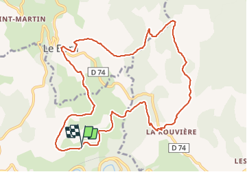
12,9 km | 17,7 km-effort
3h 53min
Non
Randonnée Randonnée équestre Le Born - Lozère eva-lior 2 jrs - Photo
Randonnée équestre
mariolive07

Randonnée équestre

Très facile
Le Born, Occitanie, Lozère, France
51 km | 66 km-effort
8h 50min
Non
Randonnée Marche Lanuéjols - Château de Chapieu - Photo
Marche
jgiraud

Marche

Facile
Lanuéjols, Occitanie, Lozère, France
6,6 km | 9,3 km-effort
2h 44min
Oui
Randonnée Moto-cross Lanuéjols - recos rando 22 juin - Photo
Moto-cross
lauz'oustal Restaurant chambres d'hôtes

Moto-cross

Facile
Lanuéjols, Occitanie, Lozère, France
103 km | 145 km-effort
5h 31min
Oui
Randonnée Marche Chastel-Nouvel - fontanes des 3 Marie  - Photo
Marche
tyntyn

Marche

Facile
Chastel-Nouvel, Occitanie, Lozère, France
9,4 km | 12,4 km-effort
2h 50min
Oui
Randonnée Marche Mende - chanteperdrix - Photo
Marche
tyntyn

Marche

Très difficile
Mende, Occitanie, Lozère, France
14,6 km | 20 km-effort
3h 24min
Oui
Randonnée V.T.T. Saint-Bauzile - aerodrome masseguin alle retaur - Photo
V.T.T.
tyntyn

V.T.T.

Moyen
Saint-Bauzile, Occitanie, Lozère, France
23 km | 29 km-effort
2h 0min
Oui
Randonnée sport Saint-Bauzile - ITILAR048V508Y7A - Photo
sport
tyntyn

sport

Très facile
Saint-Bauzile, Occitanie, Lozère, France
18 km | 24 km-effort
Inconnu
Non
Randonnée V.T.T. Brenoux - Malaval - route / vtt - Photo
V.T.T.
pocoyo

V.T.T.

Difficile
Brenoux, Occitanie, Lozère, France
23 km | 30 km-effort
1h 38min
Oui


Fermer
Mes abonnements