Randonnée Marche Nozières - rochebloine Nozières boucle - Photo

rochebloine Nozières boucle

 elcanario
elcanario

Utilisateur

© OpenStreetMap contributors
Longueur
Longueur
12,7 km
Altitude max
Altitude max
1032 m
Dénivelé positif
Dénivelé positif
440 m
Km-Effort
Km-Effort  
18,6 km
Altitude min
Altitude min
744 m
Dénivelé négatif
Dénivelé négatif
442 m
Boucle
Boucle
Oui
Date de création :
2022-10-05 09:39:48.899
Dernière modification :
2022-10-06 08:42:55.874

(0 Avis)

Marche
Marche
6h01
Difficulté : Très facile

Scannez ce code QR pour ouvrir la randonnée dans l'application SityTrail

Application GPS de randonnée GRATUITE

Logo SityTrail SityTrail

IGN / Instituts géographiques

Télécharger SityTrail sur l'App Store Télécharger SityTrail sur Google Play

Logo SityTrail SityTrail World

Le monde est à vous

Télécharger SityTrail sur l'App Store Télécharger SityTrail sur Google Play Télécharger SityTrail sur Huawei AppGallery

À propos

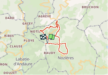
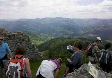
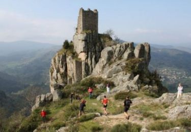
Randonnée Marche de 12,7 km à découvrir à Auvergne-Rhône-Alpes, Ardèche, Nozières. Cette randonnée est proposée par elcanario.

Description

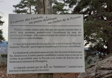
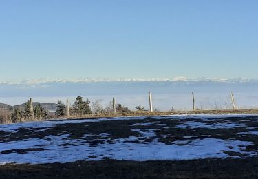
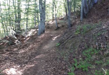
Jolie randonnée, belles vues

Profil altimétrique

Localisation

Pays :
France
Région :
Auvergne-Rhône-Alpes
Département/Province :
Ardèche
Commune :
Nozières
Localité :
Unknown
Départ:(UTM)
619898 ; 4988477 (31T) N.

Randonnées à proximité

Randonnée Marche Pailharès - Pailharès - Photo
Marche
claufranck

Marche

Très facile
(1)
Pailharès, Auvergne-Rhône-Alpes, Ardèche, France
10,2 km | 16,2 km-effort
3h 28min
Oui
Randonnée Marche Nozières - Col du Buisson - Nozières - Photo
Marche
tracegps

Marche

Moyen
Nozières, Auvergne-Rhône-Alpes, Ardèche, France
12 km | 18 km-effort
3h 30min
Oui
Randonnée Marche Désaignes - La Terrasse - Désaignes - Photo
Marche
tracegps

Marche

Moyen
Désaignes, Auvergne-Rhône-Alpes, Ardèche, France
13,3 km | 21 km-effort
4h 0min
Oui
Randonnée Marche Désaignes - Les Sauvages - Desaignes - Photo
Marche
tracegps

Marche

Moyen
Désaignes, Auvergne-Rhône-Alpes, Ardèche, France
12,3 km | 17,1 km-effort
3h 0min
Oui
Randonnée Marche Labatie-d'Andaure - Le rocher de Peyrolle Labatie d Andaure - Photo
Marche
brigitte07

Marche

Difficile
(1)
Labatie-d'Andaure, Auvergne-Rhône-Alpes, Ardèche, France
7,4 km | 12,1 km-effort
2h 1min
Oui
Randonnée Marche Nozières - rochebloine, col du buisson - Photo
Marche
brigitte07

Marche

Moyen
Nozières, Auvergne-Rhône-Alpes, Ardèche, France
7,6 km | 11,7 km-effort
1h 59min
Oui
Randonnée Marche Nozières - Nozière col du buisson Raymonde - Photo
Marche
Martine 07

Marche

Difficile
Nozières, Auvergne-Rhône-Alpes, Ardèche, France
12,3 km | 17,9 km-effort
3h 35min
Oui
Randonnée Marche Nozières - 123456 - Photo
Marche
randodan

Marche

Très facile
Nozières, Auvergne-Rhône-Alpes, Ardèche, France
14,3 km | 21 km-effort
4h 9min
Oui
Randonnée Course à pied Désaignes - Trail  l'Ardéchois 34km - édition 2010 - Photo
Course à pied
tracegps

Course à pied

Difficile
Désaignes, Auvergne-Rhône-Alpes, Ardèche, France
36 km | 56 km-effort
5h 0min
Oui


Fermer
Mes abonnements