Randonnée Randonnée équestre Lajoux - 202205 rallye Ain J3 Mijoux-PetitMontrond - Photo

202205 rallye Ain J3 Mijoux-PetitMontrond

 xhakon
xhakon

Utilisateur

© OpenStreetMap contributors
Longueur
Longueur
14,4 km
Altitude max
Altitude max
1528 m
Dénivelé positif
Dénivelé positif
617 m
Km-Effort
Km-Effort  
23 km
Altitude min
Altitude min
984 m
Dénivelé négatif
Dénivelé négatif
632 m
Boucle
Boucle
Oui
Date de création :
2022-05-28 08:44:21.426
Dernière modification :
2022-05-28 14:28:14.26

(0 Avis)

Randonnée équestre
Randonnée équestre
3h00
Difficulté : Moyen

Scannez ce code QR pour ouvrir la randonnée dans l'application SityTrail

Application GPS de randonnée GRATUITE

Logo SityTrail SityTrail

IGN / Instituts géographiques

Télécharger SityTrail sur l'App Store Télécharger SityTrail sur Google Play

Logo SityTrail SityTrail World

Le monde est à vous

Télécharger SityTrail sur l'App Store Télécharger SityTrail sur Google Play Télécharger SityTrail sur Huawei AppGallery

À propos

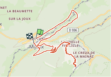
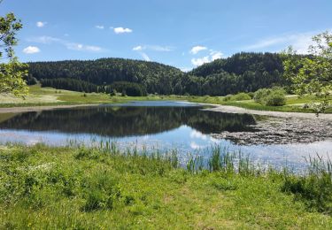
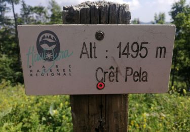
Randonnée Randonnée équestre de 14,4 km à découvrir à Bourgogne-Franche-Comté, Jura, Lajoux. Cette randonnée est proposée par xhakon.

Description

Aller-retour
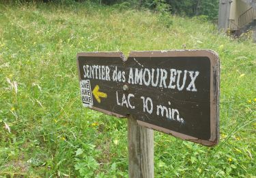
belle vue sur le lac Léman, mais chemin carrossable caillouteux

Profil altimétrique

Localisation

Pays :
France
Région :
Bourgogne-Franche-Comté
Département/Province :
Jura
Commune :
Lajoux
Localité :
Unknown
Départ:(UTM)
730421 ; 5139420 (31T) N.

Randonnées à proximité

Randonnée Marche Lamoura - Tresberruy - Lamoura - Photo
Marche
tracegps

Marche

Difficile
(1)
Lamoura, Bourgogne-Franche-Comté, Jura, France
14,5 km | 20 km-effort
4h 0min
Oui
Randonnée Vélo Lajoux - Lajoux / Bellecombe - Photo
Vélo
daniellebou

Vélo

Très facile
(1)
Lajoux, Bourgogne-Franche-Comté, Jura, France
21 km | 26 km-effort
Inconnu
Oui
Randonnée Course à pied Mijoux - UTTJ 2015-2 - Photo
Course à pied
bourel.jacques

Course à pied

Très difficile
(1)
Mijoux, Auvergne-Rhône-Alpes, Ain, France
57 km | 92 km-effort
18h 13min
Non
Randonnée Marche Lajoux - crêt vigoureuse  - Photo
Marche
eltonnermou

Marche

Moyen
Lajoux, Bourgogne-Franche-Comté, Jura, France
12,3 km | 16,8 km-effort
5h 0min
Oui
Randonnée Marche Gex - Balade à Col de la Faucille, Gex - Photo
Marche
Gaiato

Marche

Très difficile
Gex, Auvergne-Rhône-Alpes, Ain, France
86 km | 135 km-effort
9h 23min
Non
Randonnée Cyclotourisme Mijoux - LES ROUSSES - COL DE LA FAUCILLE  - Photo
Cyclotourisme
jean-marie.parachini

Cyclotourisme

Très difficile
Mijoux, Auvergne-Rhône-Alpes, Ain, France
54 km | 68 km-effort
4h 57min
Non
Randonnée Marche Lamoura - Autour Lamoura - Photo
Marche
swp648

Marche

Moyen
Lamoura, Bourgogne-Franche-Comté, Jura, France
17,1 km | 25 km-effort
4h 37min
Oui
Randonnée Marche Bellecombe - Les Moussières - Photo
Marche
Greg813

Marche

Moyen
Bellecombe, Bourgogne-Franche-Comté, Jura, France
21 km | 28 km-effort
5h 22min
Oui
Randonnée Marche Lamoura - Le Crêt Pela - Photo
Marche
Le jurassien

Marche

Moyen
Lamoura, Bourgogne-Franche-Comté, Jura, France
21 km | 28 km-effort
5h 37min
Oui


Fermer
Mes abonnements