![](/images/other/stat-length.png)
![Randonnée Randonnée équestre Gunsbach - Randonnée Equestre Chateaux du Pflixbourg et Hohlandsbourg - Photo](https://media.geolcdn.com/t/1900/400/ext.pjpeg?maxdim=2&url=https%3A%2F%2Fmedia.geolcdn.com%2Ff%2F1813dc70-1354-4adb-a6e9-e6cfffccfcba.jpg)
Randonnée Equestre Chateaux du Pflixbourg et Hohlandsbourg
Gaelle Hugg
Utilisateur
![Longueur](/images/other/stat-length.png)
Longueur
24 km
![Altitude max](https://static1.geolcdn.com/siteimages/upload/files/1508320355ic_sort_altitude_max_24dp.png)
Altitude max
629 m
![Dénivelé positif](https://static1.geolcdn.com/siteimages/upload/files/1508320355ic_sort_den_pos_24dp.png)
Dénivelé positif
583 m
![Km-Effort](/images/other/stat-length.png)
Km-Effort
32 km
![Altitude min](https://static1.geolcdn.com/siteimages/upload/files/1508320355ic_sort_altitude_min_24dp.png)
Altitude min
272 m
![Dénivelé négatif](https://static1.geolcdn.com/siteimages/upload/files/1508320355ic_sort_den_neg_24dp.png)
Dénivelé négatif
579 m
![Boucle](https://static1.geolcdn.com/siteimages/upload/files/16400158638029165_repeat_loop_refresh_sync_direction_icon.png)
Boucle
Oui
Date de création :
2021-06-29 19:33:30.557
Dernière modification :
2021-06-29 19:52:40.186
![Randonnée équestre](https://static1.geolcdn.com/sitytour/trail-icons/301.png)
4h08
Difficulté : Difficile
![Scannez ce code QR pour ouvrir la randonnée dans l'application SityTrail](https://capi.geolives.com/qq0zvz2zws4bq2lad0pu/sitytour/trails/2844223/qr.png?size=200)
Application GPS de randonnée GRATUITE
À propos
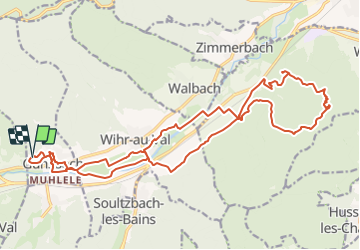
Randonnée Randonnée équestre de 24 km à découvrir à Grand Est, Haut-Rhin, Gunsbach. Cette randonnée est proposée par Gaelle Hugg.
Description
Randonnée à la journée au départ de Gunsbach, possibilité de garée à la maison du Fromage (sur demande).
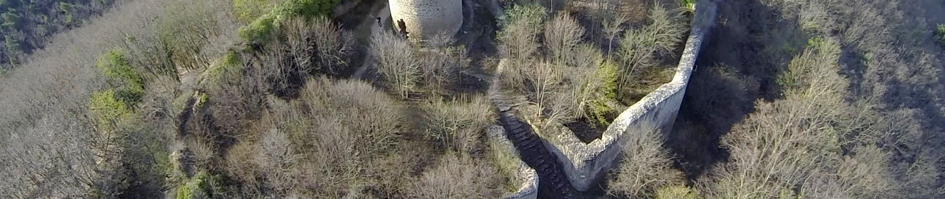
Passage par le château de Pflixbourg et le château du Hohlandsbourg.
Localisation
Pays :
France
Région :
Grand Est
Département/Province :
Haut-Rhin
Commune :
Gunsbach
Localité :
Unknown
Départ:(Dec)
Départ:(UTM)
363497 ; 5323247 (32U) N.
Commentaires
Randonnées à proximité
![Randonnée Marche Munster - De Munster aux 3 Fours (Aller) - Munster - Photo](https://media.geolcdn.com/t/375/260/ext.jpg?maxdim=2&url=https%3A%2F%2Fservices.sitytrail.com%2FGeolivesWS%2FDownloadMedia.ashx%3FTrailID%3D317996%26Media%3D17449_5.jpg)
![Marche Marche](https://static1.geolcdn.com/sitytour/trail-icons/101.png)
De Munster aux 3 Fours (Aller) - Munster
Marche
Difficile
(1)
Munster,
Grand Est,
Haut-Rhin,
France
![](/images/other/stat-length.png)
14,8 km | 27 km-effort
5h 0min
![](https://static1.geolcdn.com/siteimages/upload/files/16400158638029165_repeat_loop_refresh_sync_direction_icon.png)
Non
![Randonnée Marche Hohrod - Circuit historique 1914-18 Hohrodberg - Linge - Photo](https://media.geolcdn.com/t/375/260/ext.jpg?maxdim=2&url=https%3A%2F%2Fservices.sitytrail.com%2FGeolivesWS%2FDownloadMedia.ashx%3FTrailID%3D313116%26Media%3Dfix__20140615152326.jpg)
![Marche Marche](https://static1.geolcdn.com/sitytour/trail-icons/101.png)
Circuit historique 1914-18 Hohrodberg - Linge
Marche
Moyen
(1)
Hohrod,
Grand Est,
Haut-Rhin,
France
![](/images/other/stat-length.png)
14 km | 19,8 km-effort
5h 50min
![](https://static1.geolcdn.com/siteimages/upload/files/16400158638029165_repeat_loop_refresh_sync_direction_icon.png)
Oui
![Randonnée Marche Munster - 19.06.13.Munster - Photo](https://media.geolcdn.com/t/375/260/ext.jpg?maxdim=2&url=https%3A%2F%2Fmedia.geolcdn.com%2Ff%2F7bc30cc3-55e5-4c14-86f2-d4ff3a1f2366.jpg)
![Marche Marche](https://static1.geolcdn.com/sitytour/trail-icons/101.png)
19.06.13.Munster
Marche
Très facile
(1)
Munster,
Grand Est,
Haut-Rhin,
France
![](/images/other/stat-length.png)
7,3 km | 10,6 km-effort
2h 10min
![](https://static1.geolcdn.com/siteimages/upload/files/16400158638029165_repeat_loop_refresh_sync_direction_icon.png)
Oui
![Randonnée Randonnée équestre Gunsbach - Le petit Hohnack - verkort (23) - Photo](https://media.geolcdn.com/t/375/260/ext.jpg?maxdim=2&url=https%3A%2F%2Fstatic1.geolcdn.com%2Fsiteimages%2Fupload%2Ffiles%2F1524743154cheval.jpg)
![Randonnée équestre Randonnée équestre](https://static1.geolcdn.com/sitytour/trail-icons/301.png)
Le petit Hohnack - verkort (23)
Randonnée équestre
Facile
(1)
Gunsbach,
Grand Est,
Haut-Rhin,
France
![](/images/other/stat-length.png)
13,1 km | 18,4 km-effort
2h 25min
![](https://static1.geolcdn.com/siteimages/upload/files/16400158638029165_repeat_loop_refresh_sync_direction_icon.png)
Oui
![Randonnée Marche Soultzeren - 2022-12-27 Marche Soultzeren Lac Forlet Hautes Huttes Glasborn - Photo](https://media.geolcdn.com/t/375/260/ext.jpg?maxdim=2&url=https%3A%2F%2Fmedia.geolcdn.com%2Ff%2Ff0becfc0-aa32-4eb4-a6d5-1db6af5f7ece.jpg)
![Marche Marche](https://static1.geolcdn.com/sitytour/trail-icons/101.png)
2022-12-27 Marche Soultzeren Lac Forlet Hautes Huttes Glasborn
Marche
Très difficile
Soultzeren,
Grand Est,
Haut-Rhin,
France
![](/images/other/stat-length.png)
21 km | 34 km-effort
5h 47min
![](https://static1.geolcdn.com/siteimages/upload/files/16400158638029165_repeat_loop_refresh_sync_direction_icon.png)
Oui
![Randonnée Marche Hohrod - Hohrodberg - Le Linge - Photo](https://media.geolcdn.com/t/375/260/ext.jpg?maxdim=2&url=https%3A%2F%2Fstatic1.geolcdn.com%2Fsiteimages%2Fupload%2Ffiles%2F1553511878bg_sport_marche.png)
![Marche Marche](https://static1.geolcdn.com/sitytour/trail-icons/101.png)
Hohrodberg - Le Linge
Marche
Facile
(2)
Hohrod,
Grand Est,
Haut-Rhin,
France
![](/images/other/stat-length.png)
6,5 km | 10,3 km-effort
2h 2min
![](https://static1.geolcdn.com/siteimages/upload/files/16400158638029165_repeat_loop_refresh_sync_direction_icon.png)
Oui
![Randonnée Marche Munster - Munster Narrenstein - Photo](https://media.geolcdn.com/t/375/260/ext.jpg?maxdim=2&url=https%3A%2F%2Fstatic1.geolcdn.com%2Fsiteimages%2Fupload%2Ffiles%2F1553511878bg_sport_marche.png)
![Marche Marche](https://static1.geolcdn.com/sitytour/trail-icons/101.png)
Munster Narrenstein
Marche
Moyen
(1)
Munster,
Grand Est,
Haut-Rhin,
France
![](/images/other/stat-length.png)
4,7 km | 7,7 km-effort
1h 24min
![](https://static1.geolcdn.com/siteimages/upload/files/16400158638029165_repeat_loop_refresh_sync_direction_icon.png)
Non
![Randonnée Marche Hohrod - Hohrodberg Munster - Photo](https://media.geolcdn.com/t/375/260/ext.jpg?maxdim=2&url=https%3A%2F%2Fmedia.geolcdn.com%2Ff%2F0b0d08be-36d7-495e-91e1-463156c82cfe.jpg)
![Marche Marche](https://static1.geolcdn.com/sitytour/trail-icons/101.png)
Hohrodberg Munster
Marche
Difficile
Hohrod,
Grand Est,
Haut-Rhin,
France
![](/images/other/stat-length.png)
11,5 km | 18,6 km-effort
4h 36min
![](https://static1.geolcdn.com/siteimages/upload/files/16400158638029165_repeat_loop_refresh_sync_direction_icon.png)
Non
![Randonnée A pied Walbach - wihr au val - le petit hohnack - Photo](https://media.geolcdn.com/t/375/260/ext.jpg?maxdim=2&url=https%3A%2F%2Fstatic1.geolcdn.com%2Fsiteimages%2Fupload%2Ffiles%2F1545311037marcheuse_200dpi.jpg)
![A pied A pied](https://static1.geolcdn.com/sitytour/trail-icons/100.png)
wihr au val - le petit hohnack
A pied
Moyen
(1)
Walbach,
Grand Est,
Haut-Rhin,
France
![](/images/other/stat-length.png)
15,6 km | 25 km-effort
5h 46min
![](https://static1.geolcdn.com/siteimages/upload/files/16400158638029165_repeat_loop_refresh_sync_direction_icon.png)
Oui