![](/images/other/stat-length.png)
La Vallée de la Varenne , vu du haut de Torcy
crocheval
Utilisateur
![Longueur](/images/other/stat-length.png)
Longueur
4,5 km
![Altitude max](https://static1.geolcdn.com/siteimages/upload/files/1508320355ic_sort_altitude_max_24dp.png)
Altitude max
159 m
![Dénivelé positif](https://static1.geolcdn.com/siteimages/upload/files/1508320355ic_sort_den_pos_24dp.png)
Dénivelé positif
133 m
![Km-Effort](/images/other/stat-length.png)
Km-Effort
6,3 km
![Altitude min](https://static1.geolcdn.com/siteimages/upload/files/1508320355ic_sort_altitude_min_24dp.png)
Altitude min
34 m
![Dénivelé négatif](https://static1.geolcdn.com/siteimages/upload/files/1508320355ic_sort_den_neg_24dp.png)
Dénivelé négatif
134 m
![Boucle](https://static1.geolcdn.com/siteimages/upload/files/16400158638029165_repeat_loop_refresh_sync_direction_icon.png)
Boucle
Oui
Date de création :
2021-05-31 09:28:01.836
Dernière modification :
2021-05-31 09:36:52.973
![Marche](https://static1.geolcdn.com/sitytour/trail-icons/101.png)
1h25
Difficulté : Moyen
![Scannez ce code QR pour ouvrir la randonnée dans l'application SityTrail](https://capi.geolives.com/qq0zvz2zws4bq2lad0pu/sitytour/trails/2808683/qr.png?size=200)
Application GPS de randonnée GRATUITE
À propos
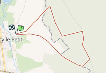
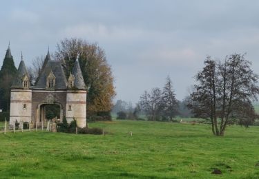
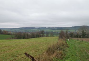
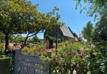
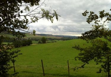
Randonnée Marche de 4,5 km à découvrir à Normandie, Seine-Maritime, Torcy-le-Petit. Cette randonnée est proposée par crocheval.
Description
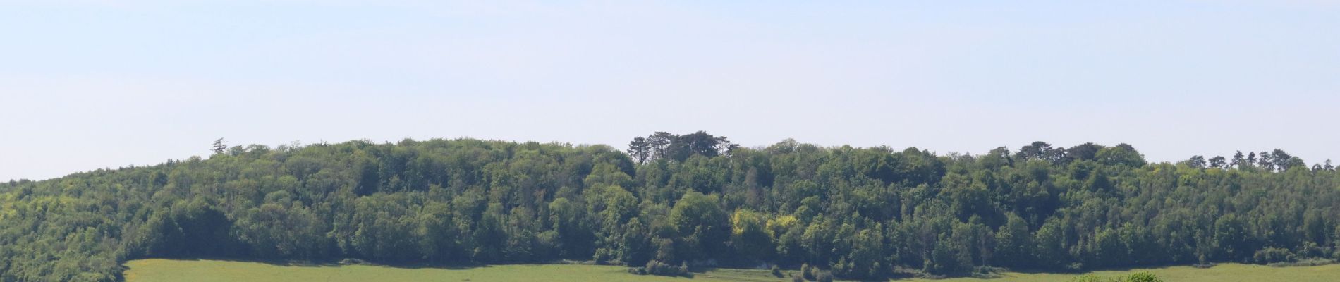
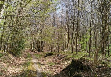
Super balade, bien ombragé. Incursion dans la forêt domaniale, pour mieux découvrir la vallée de la varenne, ainsi que Torcy par une vue extraordinaire des étangs et des alentours.
Localisation
Pays :
France
Région :
Normandie
Département/Province :
Seine-Maritime
Commune :
Torcy-le-Petit
Localité :
Unknown
Départ:(Dec)
Départ:(UTM)
368872 ; 5519704 (31U) N.
Commentaires
Randonnées à proximité
![Randonnée Marche Freulleville - Val de Ricarville - Photo](https://media.geolcdn.com/t/375/260/ext.jpg?maxdim=2&url=https%3A%2F%2Fstatic1.geolcdn.com%2Fsiteimages%2Fupload%2Ffiles%2F1553511878bg_sport_marche.png)
![Marche Marche](https://static1.geolcdn.com/sitytour/trail-icons/101.png)
Val de Ricarville
Marche
Moyen
(1)
Freulleville,
Normandie,
Seine-Maritime,
France
![](/images/other/stat-length.png)
12,9 km | 15,3 km-effort
3h 45min
![](https://static1.geolcdn.com/siteimages/upload/files/16400158638029165_repeat_loop_refresh_sync_direction_icon.png)
Oui
![Randonnée Marche Freulleville - Avenue verte Freulleville - Photo](https://media.geolcdn.com/t/375/260/ext.jpg?maxdim=2&url=https%3A%2F%2Fstatic1.geolcdn.com%2Fsiteimages%2Fupload%2Ffiles%2F1553511878bg_sport_marche.png)
![Marche Marche](https://static1.geolcdn.com/sitytour/trail-icons/101.png)
Avenue verte Freulleville
Marche
Facile
(1)
Freulleville,
Normandie,
Seine-Maritime,
France
![](/images/other/stat-length.png)
8,6 km | 10,4 km-effort
2h 16min
![](https://static1.geolcdn.com/siteimages/upload/files/16400158638029165_repeat_loop_refresh_sync_direction_icon.png)
Oui
![Randonnée V.T.T. Freulleville - fumechon - Photo](https://media.geolcdn.com/t/375/260/ext.jpg?maxdim=2&url=https%3A%2F%2Fstatic1.geolcdn.com%2Fsiteimages%2Fupload%2Ffiles%2F1524743154velo.jpg)
![V.T.T. V.T.T.](https://static1.geolcdn.com/sitytour/trail-icons/202.png)
fumechon
V.T.T.
Très difficile
(1)
Freulleville,
Normandie,
Seine-Maritime,
France
![](/images/other/stat-length.png)
48 km | 57 km-effort
3h 13min
![](https://static1.geolcdn.com/siteimages/upload/files/16400158638029165_repeat_loop_refresh_sync_direction_icon.png)
Oui
![Randonnée Marche Muchedent - muchedent - Photo](https://media.geolcdn.com/t/375/260/ext.jpg?maxdim=2&url=https%3A%2F%2Fmedia.geolcdn.com%2Ff%2Fe2b1ed44-7292-458f-830f-8bdc38fb79e5.jpg)
![Marche Marche](https://static1.geolcdn.com/sitytour/trail-icons/101.png)
muchedent
Marche
Difficile
Muchedent,
Normandie,
Seine-Maritime,
France
![](/images/other/stat-length.png)
9,5 km | 12 km-effort
1h 35min
![](https://static1.geolcdn.com/siteimages/upload/files/16400158638029165_repeat_loop_refresh_sync_direction_icon.png)
Oui
![Randonnée Marche Freulleville - forêt d'eawy torcy - Photo](https://media.geolcdn.com/t/375/260/ext.jpg?maxdim=2&url=https%3A%2F%2Fmedia.geolcdn.com%2Ff%2F6312d56a-96b5-462e-a737-70631a638906.jpg)
![Marche Marche](https://static1.geolcdn.com/sitytour/trail-icons/101.png)
forêt d'eawy torcy
Marche
Moyen
Freulleville,
Normandie,
Seine-Maritime,
France
![](/images/other/stat-length.png)
8,8 km | 11,1 km-effort
1h 36min
![](https://static1.geolcdn.com/siteimages/upload/files/16400158638029165_repeat_loop_refresh_sync_direction_icon.png)
Oui
![Randonnée Marche Dampierre-Saint-Nicolas - dampierre st Nicolas bois de pimont - Photo](https://media.geolcdn.com/t/375/260/ext.jpg?maxdim=2&url=https%3A%2F%2Fmedia.geolcdn.com%2Ff%2Fd23f809e-36cd-4a25-be10-657a5437f97f.jpg)
![Marche Marche](https://static1.geolcdn.com/sitytour/trail-icons/101.png)
dampierre st Nicolas bois de pimont
Marche
Très facile
Dampierre-Saint-Nicolas,
Normandie,
Seine-Maritime,
France
![](/images/other/stat-length.png)
7,1 km | 9,1 km-effort
1h 17min
![](https://static1.geolcdn.com/siteimages/upload/files/16400158638029165_repeat_loop_refresh_sync_direction_icon.png)
Oui
![Randonnée Marche Meulers - meulers bois de Pimont freuleville - Photo](https://media.geolcdn.com/t/375/260/ext.jpg?maxdim=2&url=https%3A%2F%2Fmedia.geolcdn.com%2Ff%2F49c24700-2425-4af0-8517-c4fdb64a3fd2.jpg)
![Marche Marche](https://static1.geolcdn.com/sitytour/trail-icons/101.png)
meulers bois de Pimont freuleville
Marche
Très facile
Meulers,
Normandie,
Seine-Maritime,
France
![](/images/other/stat-length.png)
8,2 km | 10,1 km-effort
1h 42min
![](https://static1.geolcdn.com/siteimages/upload/files/16400158638029165_repeat_loop_refresh_sync_direction_icon.png)
Oui
![Randonnée Cyclotourisme Freulleville - Arques - Offranville - Photo](https://media.geolcdn.com/t/375/260/ext.jpg?maxdim=2&url=https%3A%2F%2Fmedia.geolcdn.com%2Ff%2F61992817-3764-44b2-baee-7506d7f39c85.jpg)
![Cyclotourisme Cyclotourisme](https://static1.geolcdn.com/sitytour/trail-icons/204.png)
Arques - Offranville
Cyclotourisme
Moyen
Freulleville,
Normandie,
Seine-Maritime,
France
![](/images/other/stat-length.png)
19,9 km | 23 km-effort
1h 23min
![](https://static1.geolcdn.com/siteimages/upload/files/16400158638029165_repeat_loop_refresh_sync_direction_icon.png)
Non
![Randonnée Marche Meulers - Balade à Meulers - Photo](https://media.geolcdn.com/t/375/260/ext.jpg?maxdim=2&url=https%3A%2F%2Fservices.sitytrail.com%2FGeolivesWS%2FDownloadMedia.ashx%3FTrailID%3D172485%26Media%3D13843_1.jpg)
![Marche Marche](https://static1.geolcdn.com/sitytour/trail-icons/101.png)
Balade à Meulers
Marche
Facile
Meulers,
Normandie,
Seine-Maritime,
France
![](/images/other/stat-length.png)
13,5 km | 17,9 km-effort
2h 49min
![](https://static1.geolcdn.com/siteimages/upload/files/16400158638029165_repeat_loop_refresh_sync_direction_icon.png)
Oui