Randonnée V.T.T. Mauvezin - La Gimone - Sarrant - Photo

La Gimone - Sarrant

 lorenzot54
lorenzot54

Utilisateur

© OpenStreetMap contributors
Longueur
Longueur
25 km
Altitude max
Altitude max
181 m
Dénivelé positif
Dénivelé positif
268 m
Km-Effort
Km-Effort  
29 km
Altitude min
Altitude min
114 m
Dénivelé négatif
Dénivelé négatif
268 m
Boucle
Boucle
Oui
Date de création :
2021-03-28 08:19:12.0
Dernière modification :
2021-03-28 10:44:49.486

(0 Avis)

V.T.T.
V.T.T.
2h24
Difficulté : Facile

Scannez ce code QR pour ouvrir la randonnée dans l'application SityTrail

Application GPS de randonnée GRATUITE

Logo SityTrail SityTrail

IGN / Instituts géographiques

Télécharger SityTrail sur l'App Store Télécharger SityTrail sur Google Play

Logo SityTrail SityTrail World

Le monde est à vous

Télécharger SityTrail sur l'App Store Télécharger SityTrail sur Google Play Télécharger SityTrail sur Huawei AppGallery

À propos

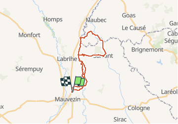
Randonnée V.T.T. de 25 km à découvrir à Occitanie, Gers, Mauvezin. Cette randonnée est proposée par lorenzot54.

Description

Départ balisage vtt, Longer la Gimone, château de Savaillan et son pigeonnier a 5 arches, chemin des pigeonniers, village médiéval de Sarrant (en rénovation), gite de Noua puis retour par-là vallée de la Gimone.

Profil altimétrique

Localisation

Pays :
France
Région :
Occitanie
Département/Province :
Gers
Commune :
Mauvezin
Localité :
Unknown
Départ:(Dec)
Départ:(UTM)
329768 ; 4844916 (31T) N.

Randonnées à proximité

Randonnée A pied Mauvezin - Mauvezin :Le Gouffre de La Hobio - Photo
A pied
jeromelacoste

A pied

Facile
(1)
Mauvezin, Occitanie, Gers, France
15,1 km | 18,8 km-effort
Inconnu
Oui
Randonnée Course à pied Mauvezin - Ronde des foies gras - Mauvezin - Photo
Course à pied
tracegps

Course à pied

Difficile
Mauvezin, Occitanie, Gers, France
25 km | 29 km-effort
3h 0min
Non
Randonnée V.T.T. Mauvezin - Ronde des foies gras - Mauvezin - Photo
V.T.T.
tracegps

V.T.T.

Moyen
Mauvezin, Occitanie, Gers, France
25 km | 29 km-effort
2h 0min
Non
Randonnée A pied Mauvezin - Circuit des Jonquilles - Photo
A pied
jeromelacoste

A pied

Facile
Mauvezin, Occitanie, Gers, France
13,4 km | 15,3 km-effort
3h 15min
Oui
Randonnée V.T.T. Mauvezin - Solomiac-Maubec - Photo
V.T.T.
lorenzot54

V.T.T.

Mauvezin, Occitanie, Gers, France
29 km | 34 km-effort
1h 51min
Oui
Randonnée Marche Mauvezin - Tour de Mauvezin - Photo
Marche
lorenzot54

Marche

Mauvezin, Occitanie, Gers, France
4,3 km | 5,2 km-effort
1h 20min
Oui
Randonnée Marche Saint-Antonin - Marie vers Saint sauvy - Photo
Marche
yves31

Marche

Très facile
Saint-Antonin, Occitanie, Gers, France
5,8 km | 6,7 km-effort
1h 28min
Non
Randonnée V.T.T. Mauvezin - Randonnée VTT - Mauvezin - Photo
V.T.T.
tracegps

V.T.T.

Moyen
Mauvezin, Occitanie, Gers, France
15,5 km | 18,3 km-effort
1h 10min
Oui
Randonnée Marche Sarrant - Sarrant Les Pigeonniers - Photo
Marche
TonioNantes

Marche

Moyen
Sarrant, Occitanie, Gers, France
8,1 km | 9,9 km-effort
3h 0min
Oui


Fermer
Mes abonnements