Randonnée Marche Istres - Tour étang dec2020 - Photo
 chrivtt
chrivtt

Utilisateur

© OpenStreetMap contributors
Longueur
Longueur
7 km
Altitude max
Altitude max
51 m
Dénivelé positif
Dénivelé positif
30 m
Km-Effort
Km-Effort  
7,4 km
Altitude min
Altitude min
37 m
Dénivelé négatif
Dénivelé négatif
30 m
Boucle
Boucle
Oui
Date de création :
2020-12-06 13:13:36.0
Dernière modification :
2020-12-06 14:57:17.332

(0 Avis)

Marche
Marche
1h12
Difficulté : Très facile

Scannez ce code QR pour ouvrir la randonnée dans l'application SityTrail

Application GPS de randonnée GRATUITE

Logo SityTrail SityTrail

IGN / Instituts géographiques

Télécharger SityTrail sur l'App Store Télécharger SityTrail sur Google Play

Logo SityTrail SityTrail World

Le monde est à vous

Télécharger SityTrail sur l'App Store Télécharger SityTrail sur Google Play Télécharger SityTrail sur Huawei AppGallery

À propos

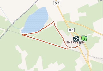
Randonnée Marche de 7 km à découvrir à Provence-Alpes-Côte d'Azur, Bouches-du-Rhône, Istres. Cette randonnée est proposée par chrivtt.

Description

Balade vers l'étang d'Entressen depuis la Mairie annexe

Profil altimétrique

Photos

Points d'intérêt

Point d'intérêt Istres - Base Nautique - Photo
chrivtt
Point d'intérêt Istres - Mas de la Tour - Photo
chrivtt

Localisation

Pays :
France
Région :
Provence-Alpes-Côte d'Azur
Département/Province :
Bouches-du-Rhône
Commune :
Istres
Localité :
Unknown
Départ:(Dec)
Départ:(UTM)
656672 ; 4828528 (31T) N.

Randonnées à proximité

Randonnée V.T.T. Istres - Challenge des entreprises Rotary Club - Photo
V.T.T.
Lecaps

V.T.T.

Facile
(1)
Istres, Provence-Alpes-Côte d'Azur, Bouches-du-Rhône, France
5,1 km | 5,6 km-effort
22min
Oui
Randonnée Marche Istres - Marche 4,4 & 5,5 - Photo
Marche
chrivtt

Marche

Istres, Provence-Alpes-Côte d'Azur, Bouches-du-Rhône, France
6,8 km | 7,2 km-effort
1h 4min
Oui
Randonnée V.T.T. Istres - Étang +boucle - Photo
V.T.T.
chrivtt

V.T.T.

Istres, Provence-Alpes-Côte d'Azur, Bouches-du-Rhône, France
8,5 km | 9 km-effort
31min
Oui
Randonnée V.T.T. Miramas -  - Photo
V.T.T.
billythekid

V.T.T.

Très facile
Miramas, Provence-Alpes-Côte d'Azur, Bouches-du-Rhône, France
27 km | 31 km-effort
2h 32min
Oui
Randonnée V.T.T. Miramas -  - Photo
V.T.T.
billythekid

V.T.T.

Très facile
Miramas, Provence-Alpes-Côte d'Azur, Bouches-du-Rhône, France
33 km | 38 km-effort
2h 58min
Non
Randonnée sport Miramas - Sortie du 260322 - Photo
sport
001284.9d5679bdaba349dfad84fbabe315a70d.1947

sport

Très facile
Miramas, Provence-Alpes-Côte d'Azur, Bouches-du-Rhône, France
32 km | 37 km-effort
Inconnu
Oui
Randonnée sport Miramas - Sortie val&pat060322 - Photo
sport
001284.9d5679bdaba349dfad84fbabe315a70d.1947

sport

Très facile
Miramas, Provence-Alpes-Côte d'Azur, Bouches-du-Rhône, France
32 km | 36 km-effort
Inconnu
Oui
Randonnée Marche Istres - 06 05 - Photo
Marche
chrivtt

Marche

Istres, Provence-Alpes-Côte d'Azur, Bouches-du-Rhône, France
3 km | 3,1 km-effort
34min
Oui
Randonnée Marche Istres - 3mar20 - Photo
Marche
chrivtt

Marche

Istres, Provence-Alpes-Côte d'Azur, Bouches-du-Rhône, France
199 m | 202 m-effort
Inconnu
Non


Fermer
Mes abonnements