Randonnée A pied Saint-Sauvy - PR de saint sauvy - Photo

PR de saint sauvy

 jeromelacoste
jeromelacoste

Utilisateur

© OpenStreetMap contributors
Longueur
Longueur
8,9 km
Altitude max
Altitude max
210 m
Dénivelé positif
Dénivelé positif
128 m
Km-Effort
Km-Effort  
10,6 km
Altitude min
Altitude min
136 m
Dénivelé négatif
Dénivelé négatif
127 m
Boucle
Boucle
Oui
Date de création :
2020-04-24 17:22:07.726
Dernière modification :
2020-05-02 14:51:15.283

(0 Avis)

A pied
A pied
1h40
Difficulté : Très facile
Course à pied
Course à pied
45m
Difficulté : Très facile
Trail
Trail
45m
Difficulté : Très facile

Scannez ce code QR pour ouvrir la randonnée dans l'application SityTrail

Application GPS de randonnée GRATUITE

Logo SityTrail SityTrail

IGN / Instituts géographiques

Télécharger SityTrail sur l'App Store Télécharger SityTrail sur Google Play

Logo SityTrail SityTrail World

Le monde est à vous

Télécharger SityTrail sur l'App Store Télécharger SityTrail sur Google Play Télécharger SityTrail sur Huawei AppGallery

À propos

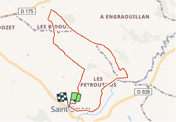
Randonnée A pied de 8,9 km à découvrir à Occitanie, Gers, Saint-Sauvy. Cette randonnée est proposée par jeromelacoste.

Description

Parcours mixte chemin goudronnée et sentier dans les bois.

Profil altimétrique

Photos

Localisation

Pays :
France
Région :
Occitanie
Département/Province :
Gers
Commune :
Saint-Sauvy
Localité :
Unknown
Départ:(UTM)
324315 ; 4840266 (31T) N.

Randonnées à proximité

Randonnée A pied Mauvezin - Mauvezin :Le Gouffre de La Hobio - Photo
A pied
jeromelacoste

A pied

Facile
(1)
Mauvezin, Occitanie, Gers, France
15,1 km | 18,8 km-effort
Inconnu
Oui
Randonnée Course à pied Mauvezin - Ronde des foies gras - Mauvezin - Photo
Course à pied
tracegps

Course à pied

Difficile
Mauvezin, Occitanie, Gers, France
25 km | 29 km-effort
3h 0min
Non
Randonnée V.T.T. Mauvezin - Ronde des foies gras - Mauvezin - Photo
V.T.T.
tracegps

V.T.T.

Moyen
Mauvezin, Occitanie, Gers, France
25 km | 29 km-effort
2h 0min
Non
Randonnée Marche Saint-Antonin - Marie vers Saint sauvy - Photo
Marche
yves31

Marche

Très facile
Saint-Antonin, Occitanie, Gers, France
5,8 km | 6,7 km-effort
1h 28min
Non
Randonnée V.T.T. Mauvezin - Randonnée VTT - Mauvezin - Photo
V.T.T.
tracegps

V.T.T.

Moyen
Mauvezin, Occitanie, Gers, France
15,5 km | 18,3 km-effort
1h 10min
Oui
Randonnée Marche Mauvezin - Mauvezin-Hobio-14446683 - Photo
Marche
pidjam

Marche

Très difficile
Mauvezin, Occitanie, Gers, France
16,2 km | 20 km-effort
4h 36min
Oui
Randonnée Marche Mauvezin - Mauvezin délices Isabelle fait - Photo
Marche
cmcmuriel.augier

Marche

Très difficile
(1)
Mauvezin, Occitanie, Gers, France
17,8 km | 22 km-effort
4h 14min
Non
Randonnée A pied Mauvezin - Moulin de dodet mauvezin - Photo
A pied
jeromelacoste

A pied

Très facile
Mauvezin, Occitanie, Gers, France
11,3 km | 13,3 km-effort
Inconnu
Oui
Randonnée A pied Mauvezin - Mauvezin arrats - Photo
A pied
jeromelacoste

A pied

Très facile
Mauvezin, Occitanie, Gers, France
6,1 km | 7,3 km-effort
Inconnu
Oui


Fermer
Mes abonnements