![](/images/other/stat-length.png)
![Randonnée Marche Valbeleix - Valbeleix_Chavade - Photo](https://media.geolcdn.com/t/1900/400/ext.pjpeg?maxdim=2&url=https%3A%2F%2Fmedia.geolcdn.com%2Ff%2F9ef0ee8a-e915-47be-914f-8572178abdde.jpg)
Valbeleix_Chavade
jagarnier
Utilisateur GUIDE
![Longueur](/images/other/stat-length.png)
Longueur
15,9 km
![Altitude max](https://static1.geolcdn.com/siteimages/upload/files/1508320355ic_sort_altitude_max_24dp.png)
Altitude max
1190 m
![Dénivelé positif](https://static1.geolcdn.com/siteimages/upload/files/1508320355ic_sort_den_pos_24dp.png)
Dénivelé positif
636 m
![Km-Effort](/images/other/stat-length.png)
Km-Effort
24 km
![Altitude min](https://static1.geolcdn.com/siteimages/upload/files/1508320355ic_sort_altitude_min_24dp.png)
Altitude min
708 m
![Dénivelé négatif](https://static1.geolcdn.com/siteimages/upload/files/1508320355ic_sort_den_neg_24dp.png)
Dénivelé négatif
633 m
![Boucle](https://static1.geolcdn.com/siteimages/upload/files/16400158638029165_repeat_loop_refresh_sync_direction_icon.png)
Boucle
Oui
Date de création :
2020-04-10 07:07:14.206
Dernière modification :
2022-04-22 09:08:35.345
![Marche](https://static1.geolcdn.com/sitytour/trail-icons/101.png)
5h15
Difficulté : Difficile
![Scannez ce code QR pour ouvrir la randonnée dans l'application SityTrail](https://capi.geolives.com/qq0zvz2zws4bq2lad0pu/sitytour/trails/2377539/qr.png?size=200)
Application GPS de randonnée GRATUITE
À propos
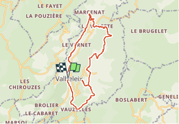
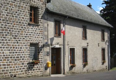
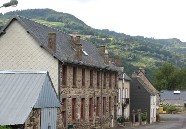
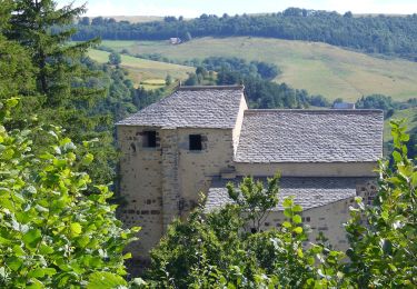
Randonnée Marche de 15,9 km à découvrir à Auvergne-Rhône-Alpes, Puy-de-Dôme, Valbeleix. Cette randonnée est proposée par jagarnier.
Description
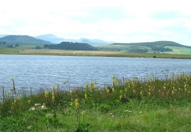
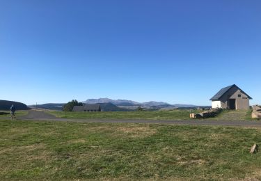
Une longue boucle autour d'une vallée glacière. La Couze de Valbeleix est un mince ruban au fond de cette auge dominée par la Roche Nité. Très beaux panoramas sur le Cézallier, les Monts-Dore et la chaine des Puys.
Localisation
Pays :
France
Région :
Auvergne-Rhône-Alpes
Département/Province :
Puy-de-Dôme
Commune :
Valbeleix
Localité :
Unknown
Départ:(Dec)
Départ:(UTM)
499050 ; 5035008 (31T) N.
Commentaires
Randonnées à proximité
![Randonnée Marche Besse-et-Saint-Anastaise - Besse_Couze_Pavin_1 - Photo](https://media.geolcdn.com/t/375/260/ext.jpg?maxdim=2&url=https%3A%2F%2Fmedia.geolcdn.com%2Ff%2F867f4cd8-780d-40b0-bf82-d96b1274a653.jpg)
![Marche Marche](https://static1.geolcdn.com/sitytour/trail-icons/101.png)
Besse_Couze_Pavin_1
Marche
Moyen
(1)
Besse-et-Saint-Anastaise,
Auvergne-Rhône-Alpes,
Puy-de-Dôme,
France
![](/images/other/stat-length.png)
11,9 km | 16,4 km-effort
3h 30min
![](https://static1.geolcdn.com/siteimages/upload/files/16400158638029165_repeat_loop_refresh_sync_direction_icon.png)
Oui
![Randonnée V.T.T. Besse-et-Saint-Anastaise - Espace VTT FFC du Sancy - Circuit n°30 - Tour des Lacs - Secteur Besse - Photo](https://media.geolcdn.com/t/375/260/ext.jpg?maxdim=2&url=https%3A%2F%2Fservices.sitytrail.com%2FGeolivesWS%2FDownloadMedia.ashx%3FTrailID%3D172888%26Media%3D14346_2.jpg)
![V.T.T. V.T.T.](https://static1.geolcdn.com/sitytour/trail-icons/202.png)
Espace VTT FFC du Sancy - Circuit n°30 - Tour des Lacs - Secteur Besse
V.T.T.
Très difficile
(1)
Besse-et-Saint-Anastaise,
Auvergne-Rhône-Alpes,
Puy-de-Dôme,
France
![](/images/other/stat-length.png)
29 km | 38 km-effort
2h 0min
![](https://static1.geolcdn.com/siteimages/upload/files/16400158638029165_repeat_loop_refresh_sync_direction_icon.png)
Oui
![Randonnée Marche Besse-et-Saint-Anastaise - Les trois lacs - Pavin - Montcineyre et Bourdouze - Photo](https://media.geolcdn.com/t/375/260/ext.jpg?maxdim=2&url=https%3A%2F%2Fservices.sitytrail.com%2FGeolivesWS%2FDownloadMedia.ashx%3FTrailID%3D107365%26Media%3D12262_2.jpg)
![Marche Marche](https://static1.geolcdn.com/sitytour/trail-icons/101.png)
Les trois lacs - Pavin - Montcineyre et Bourdouze
Marche
Difficile
(1)
Besse-et-Saint-Anastaise,
Auvergne-Rhône-Alpes,
Puy-de-Dôme,
France
![](/images/other/stat-length.png)
19,3 km | 26 km-effort
4h 49min
![](https://static1.geolcdn.com/siteimages/upload/files/16400158638029165_repeat_loop_refresh_sync_direction_icon.png)
Oui
![Randonnée A pied Besse-et-Saint-Anastaise - Le Lac de Bourdouze - Photo](https://media.geolcdn.com/t/375/260/ext.jpg?maxdim=2&url=https%3A%2F%2Fmedia.geolcdn.com%2Ff%2Ff7a95288-6f1a-402b-a564-8c941521a33d.jpeg)
![A pied A pied](https://static1.geolcdn.com/sitytour/trail-icons/100.png)
Le Lac de Bourdouze
A pied
Moyen
Besse-et-Saint-Anastaise,
Auvergne-Rhône-Alpes,
Puy-de-Dôme,
France
![](/images/other/stat-length.png)
17,4 km | 24 km-effort
5h 22min
![](https://static1.geolcdn.com/siteimages/upload/files/16400158638029165_repeat_loop_refresh_sync_direction_icon.png)
Oui
![Randonnée A pied Compains - La Chapelle Saint-Gorgon - Photo](https://media.geolcdn.com/t/375/260/ext.jpg?maxdim=2&url=https%3A%2F%2Fmedia.geolcdn.com%2Ff%2Fcf7706da-a981-451b-a81f-d62aad5b30f6.jpeg)
![A pied A pied](https://static1.geolcdn.com/sitytour/trail-icons/100.png)
La Chapelle Saint-Gorgon
A pied
Facile
Compains,
Auvergne-Rhône-Alpes,
Puy-de-Dôme,
France
![](/images/other/stat-length.png)
5,6 km | 7,7 km-effort
1h 45min
![](https://static1.geolcdn.com/siteimages/upload/files/16400158638029165_repeat_loop_refresh_sync_direction_icon.png)
Non
![Randonnée A pied Valbeleix - Le Plateau de la Chavade et la Roche Nite - Photo](https://media.geolcdn.com/t/375/260/ext.jpg?maxdim=2&url=https%3A%2F%2Fmedia.geolcdn.com%2Ff%2Fa467407f-a0fb-4883-8852-b6255f6151df.jpeg)
![A pied A pied](https://static1.geolcdn.com/sitytour/trail-icons/100.png)
Le Plateau de la Chavade et la Roche Nite
A pied
Moyen
Valbeleix,
Auvergne-Rhône-Alpes,
Puy-de-Dôme,
France
![](/images/other/stat-length.png)
15,1 km | 23 km-effort
5h 18min
![](https://static1.geolcdn.com/siteimages/upload/files/16400158638029165_repeat_loop_refresh_sync_direction_icon.png)
Oui
![Randonnée Marche Besse-et-Saint-Anastaise - Super Besse/brion - Photo](https://media.geolcdn.com/t/375/260/ext.jpg?maxdim=2&url=https%3A%2F%2Fmedia.geolcdn.com%2Ff%2Ff568cbac-9183-4806-b1cd-05e955579e61.jpg)
![Marche Marche](https://static1.geolcdn.com/sitytour/trail-icons/101.png)
Super Besse/brion
Marche
Très difficile
Besse-et-Saint-Anastaise,
Auvergne-Rhône-Alpes,
Puy-de-Dôme,
France
![](/images/other/stat-length.png)
19 km | 27 km-effort
6h 30min
![](https://static1.geolcdn.com/siteimages/upload/files/16400158638029165_repeat_loop_refresh_sync_direction_icon.png)
Non
![Randonnée A pied Roche-Charles-la-Mayrand - La Chapelle de Roche-Charles - Photo](https://media.geolcdn.com/t/375/260/ext.jpg?maxdim=2&url=https%3A%2F%2Fupload.wikimedia.org%2Fwikipedia%2Fcommons%2Fthumb%2Fd%2Fd8%2FRoche_Charles.jpg%2F2000px-Roche_Charles.jpg)
![A pied A pied](https://static1.geolcdn.com/sitytour/trail-icons/100.png)
La Chapelle de Roche-Charles
A pied
Facile
Roche-Charles-la-Mayrand,
Auvergne-Rhône-Alpes,
Puy-de-Dôme,
France
![](/images/other/stat-length.png)
4,2 km | 6,4 km-effort
1h 26min
![](https://static1.geolcdn.com/siteimages/upload/files/16400158638029165_repeat_loop_refresh_sync_direction_icon.png)
Oui
![Randonnée Marche Besse-et-Saint-Anastaise - Besse_Couze_Pavin_2 - Photo](https://media.geolcdn.com/t/375/260/ext.jpg?maxdim=2&url=https%3A%2F%2Fmedia.geolcdn.com%2Ff%2F103644bb-f3f2-4ca4-b0ef-cd62289deb10.jpg)
![Marche Marche](https://static1.geolcdn.com/sitytour/trail-icons/101.png)
Besse_Couze_Pavin_2
Marche
Moyen
Besse-et-Saint-Anastaise,
Auvergne-Rhône-Alpes,
Puy-de-Dôme,
France
![](/images/other/stat-length.png)
17,5 km | 24 km-effort
5h 15min
![](https://static1.geolcdn.com/siteimages/upload/files/16400158638029165_repeat_loop_refresh_sync_direction_icon.png)
Oui