


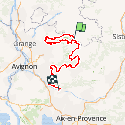

22 km | 40 km-effort

Randonnées de Vélo Loisir Provence GUIDE+


Aplicación GPS de excursión GRATIS
 SityTrail
IGN / Institutos geográficos
SityTrail World
El mundo es suyo
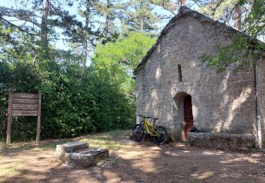
Ruta Bici de montaña de 276 km a descubrir en Provenza-Alpes-Costa Azul, Vaucluse, Savoillan. Esta ruta ha sido propuesta por Vélo Loisir Provence.
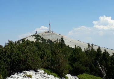
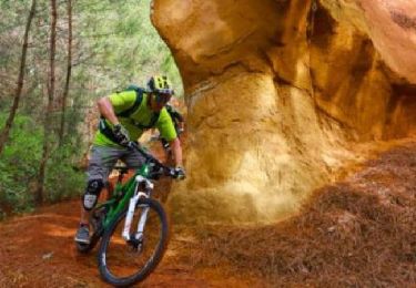
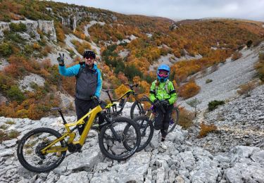
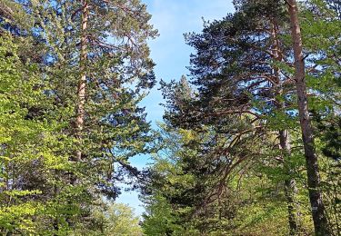
What better than by mountain bike to explore the Vaucluse region? “La Grande Traversée VTT de Vaucluse” is an itinerary composed of 18 sections (9 stages) of 16 to 30km/ 10 to 19 miles, each of which generally coincides with a stopping point such as a hostelry or village. However these sections do not take into account the difference in physical capability between a regular cyclist and a strong mountain biker and may be considered suitable only for certain cyclists. It is up to the individual to decide in respect of his technical and physical level and in view of the availability of the respective accommodation. Numerous variations are possible and there are two proposed formulae leaving from Savoillans which finish at Mérindol. Via Le Luberon in 7 stages of 35 to 55 km/22 to 35 miles, 330km/206 miles in total, difference in altitude, D :9900m and D-:9500m. Via les Monts de Vaucluse in 6 stages from 35 to 55km/22 to 35 miles, 227km/173 miles in total, difference in altitude D :7700m and D-: 8100m Note that for long weekends it’s possible to take a variant route over 3 days: Manosque – Cavaillon or to extend “La Grande Traversée de Vaucluse” from Manosque onto “La Grande Traversée VTT Alpes-Provence” via a signposted connection at Mont-Justin. More information about "La Grande Traversée VTT de Vaucluse via Les Monts-de-Vaucluse" in mountain bike in the Luberon part : GTV VTT Section 4 Aurel - Saint-Saturnin-les-Apt : 53,9 km - D : 1 015 m - D- : 1 402 m The Plateau de Sault is a landscape make up of vast open plains, shaped by fields of grains, grasses (small spelt) and lavender. From Aurel, this fast-moving route, which offers little in the way of difficulty, will lead you to Sault and its racecourse, the highest in France (800 m), through woods and open spaces. It’s then an easy descent towards Monieux followed by one of the highlights of this long distance trail: the Gorges de la Nesque. A superb path climbs up towards the Vaucluse mountains where you’ll enjoy an unforgettable view of the Gorges,one of the world’s most stunning canyons Download GPX file GTV VTT Section 7 Aurel - Saint-Hubert This long but extremely beautiful stretch boasts fabulous single-track trails through exceptional scenery. The trail through this remote and little frequented part of the Vaucluse mountains will eventually lead you to the Luberon Natural Regional Park. You’ll pass through a place known as Savouillon, after which you'll start to notice ancient stone water tanks (aiguiers), an extraordinary and typical feature of this region. The trail then descends towards Saint Saturnin-les-Apt, through the abandoned hamlet of Travignon, following a succession of paths that alternate between challenging and fast. Download GPX file GTV VTT Section 8 Saint-Hubert - Saint-Saturnin-les-Apt GTV VTT Section 5 Saint-Saturnin-les-Apt - Fontaine-de-Vaucluse : 51,5 km - D : 1 223 m - D- : 1 515 m Starting from Saint Saturnin les Apt, you will go, through vineyards and orchards, to the Combe de Font Jouval. Shortly but strongly going uphill to go to the outstanding Falaise de la Madeleine above the village of Lioux. The path above it is all mountain bike real. After Lioux, you will go uphill towards Bezaure will allow you to go through the Combe de Vaumale, then many switchbacks will lead you to the village of Murs. Download GPX file GTV VTT Section 15 Saint-Saturnin-les-Apt - Murs Starting from Murs, you will quickly go to the beautiful Combe de Véroncle and then by a technical path. You will arrive in the famous village of Gordes and all its architecture of dry rocks. After Gordes, the path will lead you to the vallon de la Sénancole, in the heart of an astonishing mineral ambient. Then you will go uphill for a while to along the vallon de la Grande Combe to go to the Rocher des Trois Luisants (alt. 661 m). Then going downhill until Saumane-de-Vaucluse and its castle. A last effort will lead you above Fontaine de Vaucluse before going downhill looking for the Sorgue and its spring. Download GPX file GTV VTT Section 16 Murs - Fontaine-de-Vaucluse GTV VTT Section 6 Fontaine-de-Vaucluse - Mérindol : 46 km - D : 950 m - D- : 868 m Cross the river Sorgue towards Lagnes, then climb the chalky hills at the extreme west of the Vaucluse mountains, past the bleak mur de la peste (plague wall). Cycle, in single file, down to the plain, towards Coustellet, past the Musée de la lavande. Then take the l’Euro-Véloroute n°8 La Méditerranée bike path (or Calavon greenway – sign EV8) towards Robion, through farmland crisscrossed by hedges and trees. Once you reach the théâtre de verdure in the centre of the old village of Robion, at the foot of the massif, you’ll see signs for the Grande Traversée (Long Distance Trail). Download GPX file GTV VTT Section 17 Fontaine-de-Vaucluse - Robion From Maubec, you’ll quickly reach the medieval villages of Robion, along delightful single track paths, then Les Taillades, cycling alongside the mythical Carpentras Canal. From here, you’ll follow some pretty, windy trails, up the western slope and then the southern side of the Petit Luberon, through a mosaic of spectacular hilltops and deep valleys. A little further up, you’ll reach a succession of limestone plateaux: Le Trou du Rat, Les Mayorques and Saint-Phalez. This scrubland, shaped by man since the Neolithic Period, is characterised by lush valleys and a remarkable variety of wildlife, with exceptional birds, particularly, birds of prey. A final climb and then it’s time for a last dramatic descent along a pretty path, down to the old village of Mérindol, symbol of the persecution of the Waldensians in the Luberon. Download GPX file GTV VTT Section 14 Maubec - Robion - Mérindol For more information on this mountain bike itinerary, go on our partner website "La Provence à Vélo".


Senderismo
Bici de montaña

Bicicleta
Senderismo
Bici de montaña
Senderismo
Bici de montaña
Senderismo
Senderismo
excellent