![](/images/other/stat-length.png)
![Excursión Senderismo Doische - Balade à Matagne-la-Grande - Photo](https://media.geolcdn.com/t/1900/400/ext.pjpeg?maxdim=2&url=https%3A%2F%2Fmedia.geolcdn.com%2Ff%2F067d5ece-ec35-4d28-bd0e-2f8ad16c5e7a.jpg)
Balade à Matagne-la-Grande
Desrumaux
Usuario GUIDE
![Longitud](/images/other/stat-length.png)
Longitud
6,3 km
![Altitud máxima](https://static1.geolcdn.com/siteimages/upload/files/1508320355ic_sort_altitude_max_24dp.png)
Altitud máxima
280 m
![Desnivel positivo](https://static1.geolcdn.com/siteimages/upload/files/1508320355ic_sort_den_pos_24dp.png)
Desnivel positivo
110 m
![Km-Effort](/images/other/stat-length.png)
Km-Effort
7,7 km
![Altitud mínima](https://static1.geolcdn.com/siteimages/upload/files/1508320355ic_sort_altitude_min_24dp.png)
Altitud mínima
197 m
![Desnivel negativo](https://static1.geolcdn.com/siteimages/upload/files/1508320355ic_sort_den_neg_24dp.png)
Desnivel negativo
111 m
![Boucle](https://static1.geolcdn.com/siteimages/upload/files/16400158638029165_repeat_loop_refresh_sync_direction_icon.png)
Boucle
Sí
Fecha de creación :
2020-07-30 08:54:38.951
Última modificación :
2020-08-02 13:59:50.545
![Senderismo](https://static1.geolcdn.com/sitytour/trail-icons/101.png)
3h42
Dificultad : Muy fácil
![Escanee este código QR para abrir la excursión en la aplicación SityTrail](https://capi.geolives.com/qq0zvz2zws4bq2lad0pu/sitytour/trails/2495731/qr.png?size=200)
Aplicación GPS de excursión GRATIS
A propósito
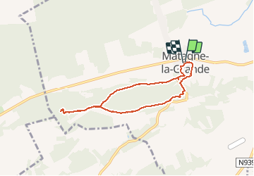
Ruta Senderismo de 6,3 km a descubrir en Valonia, Namur, Doische. Esta ruta ha sido propuesta por Desrumaux.
Descripción
Balade proposée par l'office du tourisme de Doiche
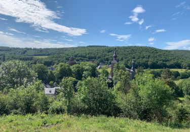
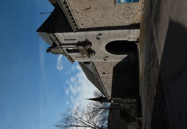
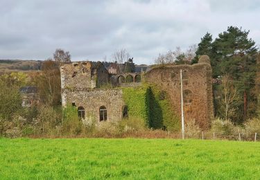
Cette promenade vous emmène par bois et campagne à la découverte d'un sanctuaire gallo-romain dans le bois de Noêl et la réserve naturelle "Les Hurées".
Départ: Eglise de Matagne-la-Grande
Localización
País:
Belgium
Región :
Valonia
Departamento/provincia :
Namur
Municipio :
Doische
Localidad:
Matagne-la-Grande
Salida:(Dec)
Salida:(UTM)
616069 ; 5552909 (31U) N.
Comentarios
Excursiones cerca
![Excursión Senderismo Viroinval - Balade dans le Viroinval - De Vierves à Olloy - Photo](https://media.geolcdn.com/t/375/260/ext.jpg?maxdim=2&url=https%3A%2F%2Fmedia.geolcdn.com%2Ff%2Feea3f008-fef3-4865-8c34-a0378b4c67ed.jpeg)
![Senderismo Senderismo](https://static1.geolcdn.com/sitytour/trail-icons/101.png)
Balade dans le Viroinval - De Vierves à Olloy
Senderismo
Muy fácil
(2)
Viroinval,
Valonia,
Namur,
Belgium
![](/images/other/stat-length.png)
8,9 km | 12,7 km-effort
4h 17min
![](https://static1.geolcdn.com/siteimages/upload/files/16400158638029165_repeat_loop_refresh_sync_direction_icon.png)
Sí
![Excursión Senderismo Viroinval - RB-Na-12 Ed4 Balade franco-belge chez Toine Culot - Photo](https://media.geolcdn.com/t/375/260/ext.jpg?maxdim=2&url=https%3A%2F%2Fservices.sitytrail.com%2FGeolivesWS%2FDownloadMedia.ashx%3FTrailID%3D794212%26Media%3D5fba0928-65b8-4f08-8244-3dd1e2295f4a.jpg)
![Senderismo Senderismo](https://static1.geolcdn.com/sitytour/trail-icons/101.png)
RB-Na-12 Ed4 Balade franco-belge chez Toine Culot
Senderismo
Medio
(2)
Viroinval,
Valonia,
Namur,
Belgium
![](/images/other/stat-length.png)
14,8 km | 21 km-effort
6h 13min
![](https://static1.geolcdn.com/siteimages/upload/files/16400158638029165_repeat_loop_refresh_sync_direction_icon.png)
Sí
![Excursión Senderismo Viroinval - Balade dans le Viroinval - De Vierves à Olloy - Photo](https://media.geolcdn.com/t/375/260/ext.jpg?maxdim=2&url=https%3A%2F%2Fservices.sitytrail.com%2FGeolivesWS%2FDownloadMedia.ashx%3FTrailID%3D394463%26Media%3D8cd58c74-46af-4e33-ad1f-b804c133f48a.JPG)
![Senderismo Senderismo](https://static1.geolcdn.com/sitytour/trail-icons/101.png)
Balade dans le Viroinval - De Vierves à Olloy
Senderismo
Fácil
(1)
Viroinval,
Valonia,
Namur,
Belgium
![](/images/other/stat-length.png)
10,5 km | 14 km-effort
3h 3min
![](https://static1.geolcdn.com/siteimages/upload/files/16400158638029165_repeat_loop_refresh_sync_direction_icon.png)
Sí
![Excursión Senderismo Viroinval - Vierves. Natura 2000, des sites qui valent le détour ! Na6 - Photo](https://media.geolcdn.com/t/375/260/ext.jpg?maxdim=2&url=https%3A%2F%2Fservices.sitytrail.com%2FGeolivesWS%2FDownloadMedia.ashx%3FTrailID%3D161505%26Media%3Dd444d70d-cecc-46cd-9982-c53f323c2b51.jpg)
![Senderismo Senderismo](https://static1.geolcdn.com/sitytour/trail-icons/101.png)
Vierves. Natura 2000, des sites qui valent le détour ! Na6
Senderismo
Fácil
(2)
Viroinval,
Valonia,
Namur,
Belgium
![](/images/other/stat-length.png)
9,7 km | 12,7 km-effort
2h 41min
![](https://static1.geolcdn.com/siteimages/upload/files/16400158638029165_repeat_loop_refresh_sync_direction_icon.png)
Sí
![Excursión Bici de montaña Viroinval - Vierves - Olloy - Petigny - Nismes - Photo](https://media.geolcdn.com/t/375/260/ext.jpg?maxdim=2&url=https%3A%2F%2Fmedia.geolcdn.com%2Ff%2Fd0c4d464-3769-46ce-b3d8-dcecdd33235b.jpeg)
![Bici de montaña Bici de montaña](https://static1.geolcdn.com/sitytour/trail-icons/202.png)
Vierves - Olloy - Petigny - Nismes
Bici de montaña
Difícil
(1)
Viroinval,
Valonia,
Namur,
Belgium
![](/images/other/stat-length.png)
34 km | 42 km-effort
2h 9min
![](https://static1.geolcdn.com/siteimages/upload/files/16400158638029165_repeat_loop_refresh_sync_direction_icon.png)
Sí
![Excursión Senderismo Viroinval - Autour de vierves sur viroin - Photo](https://media.geolcdn.com/t/375/260/ext.jpg?maxdim=2&url=https%3A%2F%2Fservices.sitytrail.com%2FGeolivesWS%2FDownloadMedia.ashx%3FTrailID%3D397913%26Media%3Dc658aef5-a80f-4049-a1f4-7bf0528ed5f1.JPG)
![Senderismo Senderismo](https://static1.geolcdn.com/sitytour/trail-icons/101.png)
Autour de vierves sur viroin
Senderismo
Medio
(3)
Viroinval,
Valonia,
Namur,
Belgium
![](/images/other/stat-length.png)
11 km | 14,6 km-effort
3h 10min
![](https://static1.geolcdn.com/siteimages/upload/files/16400158638029165_repeat_loop_refresh_sync_direction_icon.png)
Sí
![Excursión Senderismo Viroinval - A la découverte du Viroinval - Dourbes - Photo](https://media.geolcdn.com/t/375/260/ext.jpg?maxdim=2&url=https%3A%2F%2Fstatic1.geolcdn.com%2Fsiteimages%2Fupload%2Ffiles%2F1553511878bg_sport_marche.png)
![Senderismo Senderismo](https://static1.geolcdn.com/sitytour/trail-icons/101.png)
A la découverte du Viroinval - Dourbes
Senderismo
Fácil
(1)
Viroinval,
Valonia,
Namur,
Belgium
![](/images/other/stat-length.png)
12,3 km | 16,4 km-effort
3h 0min
![](https://static1.geolcdn.com/siteimages/upload/files/16400158638029165_repeat_loop_refresh_sync_direction_icon.png)
Sí
![Excursión Senderismo Viroinval - Balade dans le Viroinval - Olloy - Photo](https://media.geolcdn.com/t/375/260/ext.jpg?maxdim=2&url=https%3A%2F%2Fmedia.geolcdn.com%2Ff%2Fc6d33371-3ecb-4ffa-ae45-9aaa97ba85ec.jpeg)
![Senderismo Senderismo](https://static1.geolcdn.com/sitytour/trail-icons/101.png)
Balade dans le Viroinval - Olloy
Senderismo
Difícil
Viroinval,
Valonia,
Namur,
Belgium
![](/images/other/stat-length.png)
9,7 km | 13,2 km-effort
2h 59min
![](https://static1.geolcdn.com/siteimages/upload/files/16400158638029165_repeat_loop_refresh_sync_direction_icon.png)
Sí
![Excursión A pie Viroinval - Bayeumont - Photo](https://media.geolcdn.com/t/375/260/ext.jpg?maxdim=2&url=https%3A%2F%2Fmedia.geolcdn.com%2Ff%2F9e6b8dca-2fba-4c3c-b664-edb1a637917c.jpeg)
![A pie A pie](https://static1.geolcdn.com/sitytour/trail-icons/100.png)