Trail Walking Valensole - TOUR DESLAVANDES A VALENSOLE - Photo
© OpenStreetMap contributors
Length
Length
14.7 km
Max alt
Max alt
615 m
Uphill gradient
Uphill gradient
213 m
Km-Effort
Km-Effort  
17.5 km
Min alt
Min alt
503 m
Downhill gradient
Downhill gradient
215 m
Boucle
Boucle
Yes
Creation date :
2019-05-03 16:34:37.858
Updated on :
2019-05-03 16:34:37.907

(1 Reviews)

Walking
Walking
4h26
Difficulty : Very easy

Scan this QR Code to open this trail in the SityTrail application

FREE GPS app for hiking

Logo SityTrail SityTrail

IGN / Geographical institutes

Download SityTrail from the App Store Download SityTrail from Google Play

Logo SityTrail SityTrail World

The world is yours!

Download SityTrail from the App Store Download SityTrail from Google Play Download SityTrail on Huawei AppGallery

About

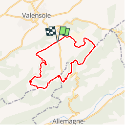
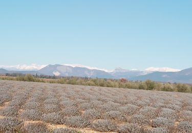
Trail Walking of 14.7 km to be discovered at Provence-Alpes-Côte d'Azur, Alpes-de-Haute-Provence, Valensole. This trail is proposed by PATRICK8455.

Description

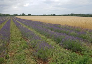
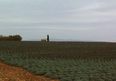
Balade autour des champs de lavandes en tout tranquillité.
période favorable de mi-juin à mi-juillet date de la Fête de la lavande

Elevation profile

Positioning

Country:
France
Region :
Provence-Alpes-Côte d'Azur
Department/Province :
Alpes-de-Haute-Provence
Municipality :
Valensole
Location:
Unknown
Start:(UTM)
741184 ; 4856709 (31T) N.

Comments

Please log in to post a review or rate the element


un peu trop de cailloux


Trails nearby

Trail Walking Valensole - Valensole - L'Adret de Notre Dame - Photo
Walking
patjobou

Walking

Medium
Valensole, Provence-Alpes-Côte d'Azur, Alpes-de-Haute-Provence, France
8 km | 9.6 km-effort
2h 26min
Yes
Trail Walking Allemagne-en-Provence - Allemagne-en-Provence - Photo
Walking
aubr

Walking

Medium
Allemagne-en-Provence, Provence-Alpes-Côte d'Azur, Alpes-de-Haute-Provence, France
6.6 km | 9.4 km-effort
1h 58min
Yes
Trail Walking Valensole - Valensole - Photo
Walking
aja

Walking

Easy
Valensole, Provence-Alpes-Côte d'Azur, Alpes-de-Haute-Provence, France
9.4 km | 11.5 km-effort
1h 42min
Yes
Trail Walking Valensole - Ravin de la Forge et la chapelle de la Trinité - Photo
Walking
aubr

Walking

Medium
Valensole, Provence-Alpes-Côte d'Azur, Alpes-de-Haute-Provence, France
10.8 km | 13.4 km-effort
2h 54min
No
Trail Walking Valensole - valensole - Photo
Walking
ARPF

Walking

Medium
Valensole, Provence-Alpes-Côte d'Azur, Alpes-de-Haute-Provence, France
16.4 km | 18.7 km-effort
4h 3min
Yes
Trail Mountain bike Allemagne-en-Provence - sortie du dimanche 9 juillet  - Photo
Mountain bike
bernardcornu

Mountain bike

Very difficult
Allemagne-en-Provence, Provence-Alpes-Côte d'Azur, Alpes-de-Haute-Provence, France
32 km | 41 km-effort
2h 35min
No
Trail Walking Valensole - valensole. Le tour du.bois d arlane - Photo
Walking
Roger

Walking

Very easy
Valensole, Provence-Alpes-Côte d'Azur, Alpes-de-Haute-Provence, France
7.7 km | 9.1 km-effort
2h 26min
Yes
Trail Walking Valensole - Valensole de Chantegalet à Capon - Photo
Walking
ejacky

Walking

Medium
Valensole, Provence-Alpes-Côte d'Azur, Alpes-de-Haute-Provence, France
7.8 km | 9.4 km-effort
2h 8min
Yes
Trail Walking Valensole - Valensole variante plus courte - Photo
Walking
ejacky

Walking

Medium
Valensole, Provence-Alpes-Côte d'Azur, Alpes-de-Haute-Provence, France
7.9 km | 9.4 km-effort
2h 8min
Yes


Close
My subscriptions