Trail Other activity Busigny - Picardie - Ligne 238 - Busigny - Hirson - Photo

Picardie - Ligne 238 - Busigny - Hirson

 mich54
mich54

User

© OpenStreetMap contributors
Length
Length
55 km
Max alt
Max alt
229 m
Uphill gradient
Uphill gradient
467 m
Km-Effort
Km-Effort  
61 km
Min alt
Min alt
121 m
Downhill gradient
Downhill gradient
416 m
Boucle
Boucle
No
Creation date :
2016-12-02 00:00:00.0
Updated on :
2016-12-02 00:00:00.0

(0 Reviews)

Other activity
Other activity
5m
Difficulty : Unknown

Scan this QR Code to open this trail in the SityTrail application

FREE GPS app for hiking

Logo SityTrail SityTrail

IGN / Geographical institutes

Download SityTrail from the App Store Download SityTrail from Google Play

Logo SityTrail SityTrail World

The world is yours!

Download SityTrail from the App Store Download SityTrail from Google Play Download SityTrail on Huawei AppGallery

About

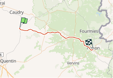
Trail Other activity of 55 km to be discovered at Hauts-de-France, Nord, Busigny. This trail is proposed by mich54.

Description

La ligne de Busigny à Hirson était une ligne ferroviaire non électrifié à double voie, puis transformée à voie unique qui reliait la gare de Busigny à celle d'Hirson.

Elle constituait la ligne 238 0001 du réseau ferré national.
Dans les années 1950, la ligne est mise à voie unique. Le trafic voyageur cesse en 1959. Le trafic fret cesse dans les années 1980.(Source Wikipédia)

Elevation profile

Positioning

Country:
France
Region :
Hauts-de-France
Department/Province :
Nord
Municipality :
Busigny
Location:
Unknown
Start:(UTM)
531711 ; 5542645 (31U) N.

Trails nearby

Trail Other activity Busigny - Nord - Pas-de-Calais - Ligne 238 - Busigny - Hirson - Photo
Other activity
mich54

Other activity

Very easy
Busigny, Hauts-de-France, Nord, France
13 km | 14.5 km-effort
5min
No


Close
My subscriptions