Trail Walking Haut-Intyamon - Comba d’Avau – Montbovon - Photo

Comba d’Avau – Montbovon

 gpiller
gpiller

User

© OpenStreetMap contributors
Length
Length
8.1 km
Max alt
Max alt
975 m
Uphill gradient
Uphill gradient
297 m
Km-Effort
Km-Effort  
12 km
Min alt
Min alt
777 m
Downhill gradient
Downhill gradient
298 m
Boucle
Boucle
Yes
Creation date :
2019-02-26 08:45:40.034
Updated on :
2019-02-26 08:45:40.065

(0 Reviews)

Walking
Walking
2h30
Difficulty : Medium

Scan this QR Code to open this trail in the SityTrail application

FREE GPS app for hiking

Logo SityTrail SityTrail

IGN / Geographical institutes

Download SityTrail from the App Store Download SityTrail from Google Play

Logo SityTrail SityTrail World

The world is yours!

Download SityTrail from the App Store Download SityTrail from Google Play Download SityTrail on Huawei AppGallery

About

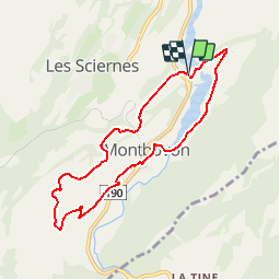
Trail Walking of 8.1 km to be discovered at Fribourg, Gruyère District, Haut-Intyamon. This trail is proposed by gpiller.

Description

Parcours proposé par Gabriel Dematraz.
Bicubic - Vaulruz - A12 -H189 - route de l'Intyamon - Comba d'Avau. Parking sur l'ancienne route près des ponts, à ~ 1km avant Montbovon. Dist: 37km, 35min, Fr 6.00
Verrée à l'Auberge de l'Ange Tél: 026 9281113

Elevation profile

Points of interest

Point of interest Haut-Intyamon - D/A - Photo
gpiller
HAUT-INTYAMON 
Point of interest  - 1 - Photo
gpiller
 
Point of interest Haut-Intyamon - 3 - Photo
gpiller
HAUT-INTYAMON 
Point of interest Haut-Intyamon - 4 - Photo
gpiller
HAUT-INTYAMON 
Point of interest  - 5 - Photo
gpiller
 
Point of interest  - 6 - Photo
gpiller
 
Point of interest  - 7 - Photo
gpiller
 
Point of interest Haut-Intyamon - 8 - Photo
gpiller
HAUT-INTYAMON 

Positioning

Country:
Switzerland
Region :
Fribourg
Department/Province :
Gruyère District
Municipality :
Haut-Intyamon
Location:
Unknown
Start:(UTM)
350385 ; 5150984 (32T) N.

Trails nearby

Trail Cycle Rossinière - Rossinière - Vevey - Photo
Cycle
karawatsj

Cycle

Very difficult
Rossinière, Vaud, District de la Riviera-Pays-d’Enhaut, Switzerland
88 km | 115 km-effort
5h 56min
No
Trail Walking Haut-Intyamon - st_test3 - Photo
Walking
GUIDE+

Walking

Very easy
Haut-Intyamon, Fribourg, Gruyère District, Switzerland
7.5 km | 11 km-effort
2h 34min
No
Trail Snowshoes  - Albeuve-Les Avants - Photo
Snowshoes
lroux

Snowshoes

Very easy
, Fribourg, Gruyère District, Switzerland
18.9 km | 35 km-effort
Unknown
No
Trail Other activity  - RAF 2008 - Photo
Other activity
pierrepraz

Other activity

Very easy
, Fribourg, Gruyère District, Switzerland
5 km | 9.5 km-effort
Unknown
No
Trail Other activity  - Les Cases - Jaman - Photo
Other activity
pierrepraz

Other activity

Very easy
, Fribourg, Gruyère District, Switzerland
3.4 km | 7.3 km-effort
Unknown
No
Trail Other activity Châtel-Saint-Denis - Dent de Lys - Photo
Other activity
daniel

Other activity

Very easy
Châtel-Saint-Denis, Fribourg, District de la Veveyse, Switzerland
4 km | 10 km-effort
2h 59min
No
Trail Walking Grandvillard - Le Vanil Noir par Bounavaux - Photo
Walking
otrement

Walking

Very easy
Grandvillard, Fribourg, Gruyère District, Switzerland
8.6 km | 23 km-effort
4h 40min
Yes
Trail Other activity  - FR - Dent de Lys, Montbovon - Photo
Other activity
sterrettaz

Other activity

Very easy
, Fribourg, Gruyère District, Switzerland
4.2 km | 14 km-effort
Unknown
No
Trail Other activity Rossinière - Rossiniere Allières - Photo
Other activity
lush

Other activity

Very easy
Rossinière, Vaud, District de la Riviera-Pays-d’Enhaut, Switzerland
12.8 km | 24 km-effort
Unknown
No


Close
My subscriptions