Trail Running Gorbio - Course découverte Gorbio - Photo
 kenhava
kenhava

User

© OpenStreetMap contributors
Length
Length
28 km
Max alt
Max alt
1239 m
Uphill gradient
Uphill gradient
1561 m
Km-Effort
Km-Effort  
49 km
Min alt
Min alt
361 m
Downhill gradient
Downhill gradient
1555 m
Boucle
Boucle
Yes
Creation date :
2015-05-14 00:00:00.0
Updated on :
2015-05-14 00:00:00.0

(0 Reviews)

Running
Running
4h33
Difficulty : Difficult

Scan this QR Code to open this trail in the SityTrail application

FREE GPS app for hiking

Logo SityTrail SityTrail

IGN / Geographical institutes

Download SityTrail from the App Store Download SityTrail from Google Play

Logo SityTrail SityTrail World

The world is yours!

Download SityTrail from the App Store Download SityTrail from Google Play Download SityTrail on Huawei AppGallery

About

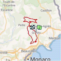
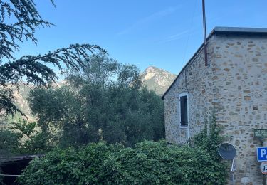
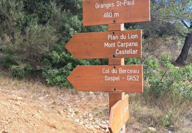
Trail Running of 28 km to be discovered at Provence-Alpes-Côte d'Azur, Maritime Alps, Gorbio. This trail is proposed by kenhava.

Description

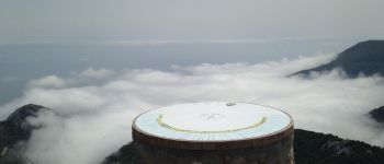
Superbe parcours au dessus des nuages.Difficile en 2ème partie surtout quand on n'emporte pas assez d'eau....

Elevation profile

Photos

Points of interest

Point of interest Peille - Point 3 - Photo
kenhava
PEILLE 

Positioning

Country:
France
Region :
Provence-Alpes-Côte d'Azur
Department/Province :
Maritime Alps
Municipality :
Gorbio
Location:
Unknown
Start:(UTM)
374742 ; 4849351 (32T) N.

Trails nearby

Trail Walking Castellar - Mont Carpano en boucle - Photo
Walking
boboazur

Walking

Medium
(1)
Castellar, Provence-Alpes-Côte d'Azur, Maritime Alps, France
8.1 km | 14.4 km-effort
3h 18min
Yes
Trail Walking Peillon - Via Alpina - R161: Peillon > Monaco - Place du Palais - Photo
Walking
tracegps

Walking

Medium
(2)
Peillon, Provence-Alpes-Côte d'Azur, Maritime Alps, France
10.3 km | 16.7 km-effort
2h 49min
No
Trail On foot Peille - Cime de Baudon - Photo
On foot
PRO

On foot

Easy
Peille, Provence-Alpes-Côte d'Azur, Maritime Alps, France
7 km | 14.7 km-effort
3h 20min
Yes
Trail Walking Roquebrune-Cap-Martin - cape martin - Photo
Walking
danpar

Walking

Medium
(2)
Roquebrune-Cap-Martin, Provence-Alpes-Côte d'Azur, Maritime Alps, France
4.4 km | 5.9 km-effort
1h 57min
Yes
Trail Other activity La Turbie - fort de la Revere  - Photo
Other activity
juleyann

Other activity

Very easy
(1)
La Turbie, Provence-Alpes-Côte d'Azur, Maritime Alps, France
8.4 km | 12 km-effort
1h 37min
Yes
Trail Walking Peille - Cime de Baudon - Photo
Walking
maxcagaze

Walking

Medium
(1)
Peille, Provence-Alpes-Côte d'Azur, Maritime Alps, France
7.8 km | 15.7 km-effort
4h 15min
Yes
Trail sport Peillon - Haut de Peillln - Photo
sport
jwo47

sport

Very easy
Peillon, Provence-Alpes-Côte d'Azur, Maritime Alps, France
6.8 km | 10.2 km-effort
Unknown
Yes
Trail Walking Castellar - Castellar Gramondo Bocca Bassa Col St Bernard Monti réel - Photo
Walking
jouans

Walking

Very difficult
Castellar, Provence-Alpes-Côte d'Azur, Maritime Alps, France
18.1 km | 36 km-effort
8h 17min
Yes
Trail Walking Castellar - mont carpano au départ de Castellar - Photo
Walking
56jj

Walking

Medium
Castellar, Provence-Alpes-Côte d'Azur, Maritime Alps, France
7.7 km | 13.9 km-effort
5h 14min
Yes


Close
My subscriptions