Trail Walking Questembert - AUDAX 50 KMS QUESTEMBERT  - Photo

AUDAX 50 KMS QUESTEMBERT

© OpenStreetMap contributors
Length
Length
51 km
Max alt
Max alt
125 m
Uphill gradient
Uphill gradient
598 m
Km-Effort
Km-Effort  
59 km
Min alt
Min alt
39 m
Downhill gradient
Downhill gradient
599 m
Boucle
Boucle
Yes
Creation date :
2024-05-18 05:00:23.949
Updated on :
2024-05-18 20:18:22.869

(0 Reviews)

Walking
Walking
8h35
Difficulty : Difficult

Scan this QR Code to open this trail in the SityTrail application

FREE GPS app for hiking

Logo SityTrail SityTrail

IGN / Geographical institutes

Download SityTrail from the App Store Download SityTrail from Google Play

Logo SityTrail SityTrail World

The world is yours!

Download SityTrail from the App Store Download SityTrail from Google Play Download SityTrail on Huawei AppGallery

About

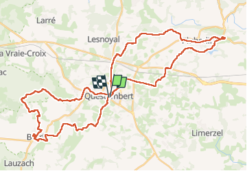
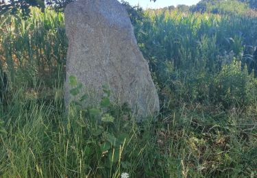
Trail Walking of 51 km to be discovered at Brittany, Morbihan, Questembert. This trail is proposed by JEAN06910.

Description

Bel Audax, avec 2 circuits différents  le 1er étant plus sur des chemins.

Belle organisation.

Elevation profile

Photos

Positioning

Country:
France
Region :
Brittany
Department/Province :
Morbihan
Municipality :
Questembert
Location:
Unknown
Start:(UTM)
541204 ; 5278633 (30T) N.

Trails nearby

Trail Walking Questembert - PR_56_Questembert_AA_01_Circuit1b_Sentier-Des-Popinettes_20200521 - Photo
Walking
patrickdanilo

Walking

Easy
(1)
Questembert, Brittany, Morbihan, France
14 km | 16.9 km-effort
3h 41min
Yes
Trail Walking Questembert - PR_56_Questembert_BA_02_Circuit1b_La-Boucle-Du-St-Eloi_20220807 - Photo
Walking
patrickdanilo

Walking

Easy
Questembert, Brittany, Morbihan, France
9.8 km | 11.2 km-effort
1h 59min
Yes
Trail On foot Questembert - Boucles du Bois de St Martin - Photo
On foot
PRO

On foot

Easy
Questembert, Brittany, Morbihan, France
3.6 km | 4.6 km-effort
1h 2min
Yes
Trail Walking Questembert - 228 - rando de Cela à Saint Doué par la Vraie Croix  - Photo
Walking
Pierre-yves Leclerc

Walking

Easy
Questembert, Brittany, Morbihan, France
13.6 km | 15.8 km-effort
3h 21min
No
Trail Walking Questembert - 188- la boucle de Saint Eloi - Photo
Walking
Pierre-yves Leclerc

Walking

Medium
Questembert, Brittany, Morbihan, France
14.2 km | 16.1 km-effort
3h 26min
Yes
Trail Walking Questembert - 181 La boucle de Brangolo - Photo
Walking
Pierre-yves Leclerc

Walking

Easy
Questembert, Brittany, Morbihan, France
14.9 km | 17.3 km-effort
3h 31min
No
Trail Walking Questembert - castel - Photo
Walking
bourdet

Walking

Very difficult
Questembert, Brittany, Morbihan, France
55 km | 68 km-effort
8h 45min
No
Trail sport Questembert - SityTrail - 3312871 - sentier-des-popinettesx-questembert - Photo
sport
leho.yannick@orange.fr

sport

Very easy
Questembert, Brittany, Morbihan, France
14.5 km | 17.5 km-effort
Unknown
Yes
Trail Walking Questembert - questembert - Photo
Walking
gooogor

Walking

Very easy
Questembert, Brittany, Morbihan, France
17.9 km | 22 km-effort
4h 0min
Yes


Close
My subscriptions