Trail Walking Meudon - Forêt de meudon avec chevreuil  - Photo

Forêt de meudon avec chevreuil

© OpenStreetMap contributors
Length
Length
8.8 km
Max alt
Max alt
187 m
Uphill gradient
Uphill gradient
110 m
Km-Effort
Km-Effort  
10.4 km
Min alt
Min alt
120 m
Downhill gradient
Downhill gradient
172 m
Boucle
Boucle
No
Creation date :
2023-05-01 15:07:15.0
Updated on :
2023-05-01 17:22:22.325

(0 Reviews)

Walking
Walking
1h49
Difficulty : Medium

Scan this QR Code to open this trail in the SityTrail application

FREE GPS app for hiking

Logo SityTrail SityTrail

IGN / Geographical institutes

Download SityTrail from the App Store Download SityTrail from Google Play

Logo SityTrail SityTrail World

The world is yours!

Download SityTrail from the App Store Download SityTrail from Google Play Download SityTrail on Huawei AppGallery

About

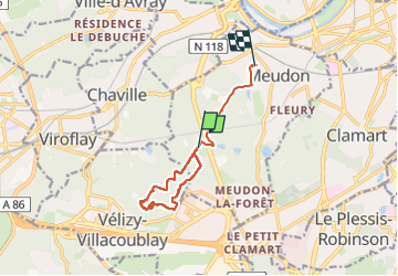
Trail Walking of 8.8 km to be discovered at Ile-de-France, Hauts-de-Seine, Meudon. This trail is proposed by petergole.

Description

Chevreuil mort trouvé au point d’intérêt

Elevation profile

Positioning

Country:
France
Region :
Ile-de-France
Department/Province :
Hauts-de-Seine
Municipality :
Meudon
Location:
Unknown
Start:(UTM)
442257 ; 5405276 (31U) N.

Trails nearby

Trail Walking Chaville - Le Sentier des 7 étangs - Photo
Walking
tracegps

Walking

Difficult
(5)
Chaville, Ile-de-France, Hauts-de-Seine, France
23 km | 31 km-effort
5h 0min
Yes
Trail Walking Chaville - GRP CV-IDF 20R Chaville à Vaucresson - Photo
Walking
clalaur

Walking

Medium
(1)
Chaville, Ile-de-France, Hauts-de-Seine, France
8.2 km | 11.1 km-effort
2h 30min
No
Trail Walking Jouy-en-Josas - GRP CV-IDF 2023 - Photo
Walking
clalaur

Walking

Difficult
(1)
Jouy-en-Josas, Ile-de-France, Yvelines, France
11.2 km | 14.5 km-effort
3h 17min
No
Trail Walking Jouy-en-Josas - ferme viltain - Photo
Walking
papoune69

Walking

Very easy
(2)
Jouy-en-Josas, Ile-de-France, Yvelines, France
9 km | 10.1 km-effort
2h 13min
Yes
Trail Walking Verrières-le-Buisson - Sur les sentiers de découverte du Bois de Verrières - Photo
Walking
tracegps

Walking

Medium
(2)
Verrières-le-Buisson, Ile-de-France, Essonne, France
22 km | 27 km-effort
4h 40min
Yes
Trail Walking Viroflay - Les 3 Forêts; Meudon, Fausses Reposes et Versailles - Photo
Walking
tracegps

Walking

Difficult
(2)
Viroflay, Ile-de-France, Yvelines, France
25 km | 32 km-effort
5h 19min
Yes
Trail Walking Chaville - Sentier des deux Forêts - Meudon et Verrières - Photo
Walking
tracegps

Walking

Difficult
(2)
Chaville, Ile-de-France, Hauts-de-Seine, France
23 km | 29 km-effort
5h 0min
Yes
Trail Walking Sceaux - Les Hauts de Bièvre - Photo
Walking
tracegps

Walking

Difficult
(2)
Sceaux, Ile-de-France, Hauts-de-Seine, France
25 km | 30 km-effort
6h 0min
Yes
Trail Walking Boulogne-Billancourt - Parc de St Cloud et forêt de Fausses Reposes - Photo
Walking
tracegps

Walking

Medium
(1)
Boulogne-Billancourt, Ile-de-France, Hauts-de-Seine, France
18.2 km | 23 km-effort
4h 30min
No


Close
My subscriptions