Trail Walking Boussy-Saint-Antoine - Boucle 27 km autour de Boussy / Varennes / Combs - Photo

Boucle 27 km autour de Boussy / Varennes / Combs

 chessyca
chessyca

User

© OpenStreetMap contributors
Length
Length
27 km
Max alt
Max alt
100 m
Uphill gradient
Uphill gradient
309 m
Km-Effort
Km-Effort  
31 km
Min alt
Min alt
41 m
Downhill gradient
Downhill gradient
307 m
Boucle
Boucle
Yes
Creation date :
2023-03-29 06:20:33.86
Updated on :
2023-03-29 14:51:28.688

(0 Reviews)

Walking
Walking
5h44
Difficulty : Medium

Scan this QR Code to open this trail in the SityTrail application

FREE GPS app for hiking

Logo SityTrail SityTrail

IGN / Geographical institutes

Download SityTrail from the App Store Download SityTrail from Google Play

Logo SityTrail SityTrail World

The world is yours!

Download SityTrail from the App Store Download SityTrail from Google Play Download SityTrail on Huawei AppGallery

About

Trail Walking of 27 km to be discovered at Ile-de-France, Essonne, Boussy-Saint-Antoine. This trail is proposed by chessyca.

Description

Jolie boucle idéale au printemps
Aucune difficulté hormis la distance

Elevation profile

Photos

Positioning

Country:
France
Region :
Ile-de-France
Department/Province :
Essonne
Municipality :
Boussy-Saint-Antoine
Location:
Unknown
Start:(UTM)
465147 ; 5393161 (31U) N.

Trails nearby

Trail Walking Boussy-Saint-Antoine - GRP CV-IDF 04 - Photo
Walking
clalaur

Walking

Difficult
(1)
Boussy-Saint-Antoine, Ile-de-France, Essonne, France
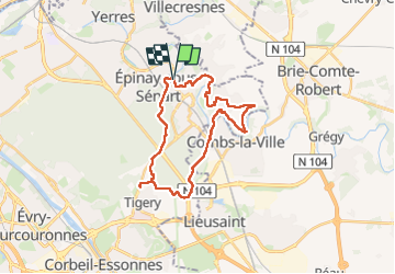
16.8 km | 18.6 km-effort
4h 13min
No
Trail Walking Mandres-les-Roses - J 26 Mandres, Boussy , Brunoy le chemin des fresques  - Photo
Walking

Walking

Medium
(2)
Mandres-les-Roses, Ile-de-France, Val-de-Marne, France
12.2 km | 13.8 km-effort
3h 7min
Yes
Trail On foot Servon - J 01  11.97 km  les 5 châteaux  - Photo
On foot

On foot

Medium
(1)
Servon, Ile-de-France, Seine-et-Marne, France
11.7 km | 13.2 km-effort
3h 3min
Yes
Trail On foot Servon - R 04 - 8 km -  Servon, Santeny, Servon - Photo
On foot

On foot

Very difficult
(4)
Servon, Ile-de-France, Seine-et-Marne, France
7.9 km | 9.1 km-effort
2h 3min
Yes
Trail Walking Yerres - BM Foret Regionale de Grobois 10km - Photo
Walking
GUIDE
jeanmarcMasson

Walking

Medium
(1)
Yerres, Ile-de-France, Essonne, France
10.4 km | 11 km-effort
2h 30min
Yes
Trail Walking Yerres - BM Foret Regionale Grosbois 10km - Photo
Walking
GUIDE
jeanmarcMasson

Walking

Medium
(1)
Yerres, Ile-de-France, Essonne, France
9.8 km | 10.5 km-effort
2h 23min
Yes
Trail On foot Brunoy - L 39 Brunoy, les bords de l'Yerres - Photo
On foot

On foot

Very easy
(4)
Brunoy, Ile-de-France, Essonne, France
5.4 km | 6.1 km-effort
1h 49min
Yes
Trail Walking Montgeron - J 38 Montgeron la Pelouse, forêt de Sénart - Photo
Walking

Walking

Medium
(3)
Montgeron, Ile-de-France, Essonne, France
12.3 km | 13.2 km-effort
3h 9min
Yes
Trail On foot Quincy-sous-Sénart - J 77 Tigery, Allée Royale - Photo
On foot

On foot

Medium
(3)
Quincy-sous-Sénart, Ile-de-France, Essonne, France
10.6 km | 12 km-effort
2h 44min
Yes


Close
My subscriptions