Trail Trail Laveissière - Puy de Peyre Arse/ Puy Bataillouse / Téton de Vénus et Rocher du bec de l'aigle  - Photo

Puy de Peyre Arse/ Puy Bataillouse / Téton de Vénus et Rocher du bec de l'aigle

 nadd73
nadd73

User GUIDE

© OpenStreetMap contributors
Length
Length
12.8 km
Max alt
Max alt
1783 m
Uphill gradient
Uphill gradient
878 m
Km-Effort
Km-Effort  
25 km
Min alt
Min alt
1198 m
Downhill gradient
Downhill gradient
887 m
Boucle
Boucle
Yes
Creation date :
2022-07-08 09:53:22.731
Updated on :
2022-07-08 18:05:33.041

(0 Reviews)

Trail
Trail
3h04
Difficulty : Medium

Scan this QR Code to open this trail in the SityTrail application

FREE GPS app for hiking

Logo SityTrail SityTrail

IGN / Geographical institutes

Download SityTrail from the App Store Download SityTrail from Google Play

Logo SityTrail SityTrail World

The world is yours!

Download SityTrail from the App Store Download SityTrail from Google Play Download SityTrail on Huawei AppGallery

About

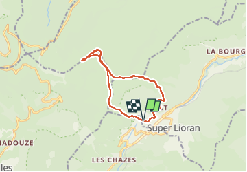
Trail Trail of 12.8 km to be discovered at Auvergne-Rhône-Alpes, Cantal, Laveissière. This trail is proposed by nadd73.

Description

Départ du col de fond de Cère.
Partie des Albepierre à vélo.
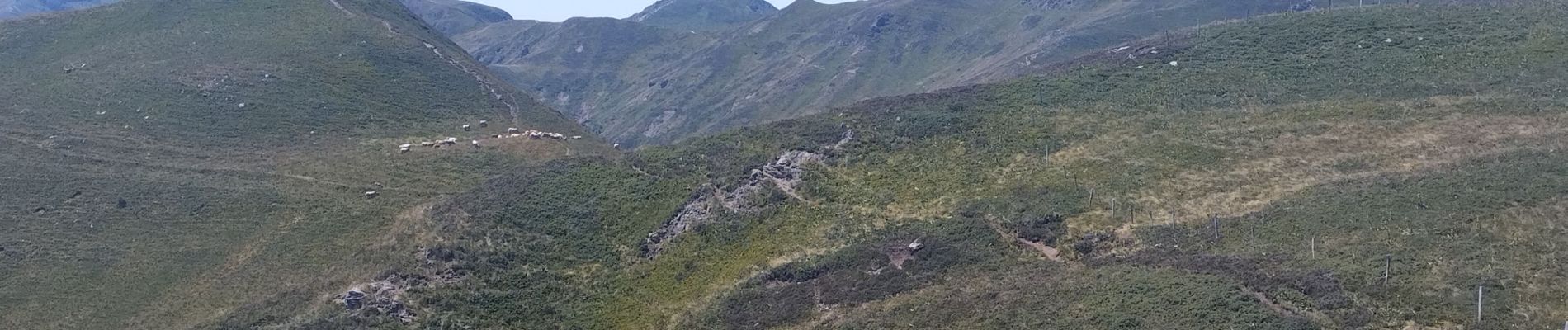
Panorama magnifique , pas très loin du Puy Mary.
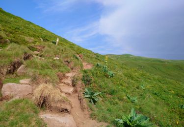
La descente du bec de l'aigle et un peu raide.

Elevation profile

Photos

Positioning

Country:
France
Region :
Auvergne-Rhône-Alpes
Department/Province :
Cantal
Municipality :
Laveissière
Location:
Unknown
Start:(UTM)
479072 ; 4992478 (31T) N.

Trails nearby

Trail Walking Albepierre-Bredons - Cantal - Col de Prat de Bouc Le Plomb du Cantal - 8.2km 450m 2h45 - 2019 07 06 - Photo
Walking
GUIDE
Orcal37

Walking

Medium
(1)
Albepierre-Bredons, Auvergne-Rhône-Alpes, Cantal, France
8.2 km | 14.2 km-effort
2h 45min
Yes
Trail Walking Laveissière - Le Puy Griou de Super Lioran - Photo
Walking
tracegps

Walking

Medium
(2)
Laveissière, Auvergne-Rhône-Alpes, Cantal, France
11.9 km | 19.7 km-effort
5h 0min
Yes
Trail Walking Laveissière - Le plomb du Cantal - Le Lioran - Photo
Walking
tracegps

Walking

Medium
(1)
Laveissière, Auvergne-Rhône-Alpes, Cantal, France
14.4 km | 27 km-effort
6h 0min
Yes
Trail Walking Laveissière - Les crêtes du Cantal - Le Lioran - Photo
Walking
tracegps

Walking

Difficult
(4)
Laveissière, Auvergne-Rhône-Alpes, Cantal, France
28 km | 51 km-effort
7h 30min
Yes
Trail Walking Laveissière - le Peyre Arse - Le Lioran - Photo
Walking
tracegps

Walking

Difficult
(1)
Laveissière, Auvergne-Rhône-Alpes, Cantal, France
11.2 km | 19.4 km-effort
4h 0min
No
Trail Walking Laveissière - Lioran 2023-08-18 Col de Rombière Col du Pertus A/R - Photo
Walking
marionneau

Walking

Easy
(1)
Laveissière, Auvergne-Rhône-Alpes, Cantal, France
12.5 km | 18.8 km-effort
4h 14min
Yes
Trail Walking Laveissière - Lioran 2023-08-11 Col du Pertus - Photo
Walking
marionneau

Walking

Medium
(1)
Laveissière, Auvergne-Rhône-Alpes, Cantal, France
17.3 km | 25 km-effort
2h 57min
Yes
Trail Walking Laveissière - Lioran 2023-08-09 Puy de Seycheuse - Photo
Walking
marionneau

Walking

Very difficult
(1)
Laveissière, Auvergne-Rhône-Alpes, Cantal, France
13.9 km | 23 km-effort
5h 20min
Yes
Trail Walking Laveissière - Cantal - le Lioran - Bec de l Aigle - 10.8km 540m 4h55 - 2019 06 26 - Photo
Walking
GUIDE
Orcal37

Walking

Medium
Laveissière, Auvergne-Rhône-Alpes, Cantal, France
10.8 km | 18 km-effort
5h 0min
Yes


Close
My subscriptions