Trail Electric bike Draix - Draix 2 - Photo
© OpenStreetMap contributors
Length
Length
19 km
Max alt
Max alt
1511 m
Uphill gradient
Uphill gradient
817 m
Km-Effort
Km-Effort  
30 km
Min alt
Min alt
831 m
Downhill gradient
Downhill gradient
814 m
Boucle
Boucle
Yes
Creation date :
2022-05-15 08:03:07.0
Updated on :
2022-05-15 11:54:08.414

(0 Reviews)

Electric bike
Electric bike
3h50
Difficulty : Medium

Scan this QR Code to open this trail in the SityTrail application

FREE GPS app for hiking

Logo SityTrail SityTrail

IGN / Geographical institutes

Download SityTrail from the App Store Download SityTrail from Google Play

Logo SityTrail SityTrail World

The world is yours!

Download SityTrail from the App Store Download SityTrail from Google Play Download SityTrail on Huawei AppGallery

About

Trail Electric bike of 19 km to be discovered at Provence-Alpes-Côte d'Azur, Alpes-de-Haute-Provence, Draix. This trail is proposed by AppleAnonymous---8wpffzsen.

Description

Beau pluie

Elevation profile

Positioning

Country:
France
Region :
Provence-Alpes-Côte d'Azur
Department/Province :
Alpes-de-Haute-Provence
Municipality :
Draix
Location:
Unknown
Start:(UTM)
289250 ; 4890356 (32T) N.

Trails nearby

Trail Walking Draix - DRAIX .REFUGE DE BELON .CRETE DE LA BLACHE .O L  - Photo
Walking
RobinMicheline

Walking

Medium
Draix, Provence-Alpes-Côte d'Azur, Alpes-de-Haute-Provence, France
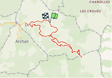
13.7 km | 22 km-effort
4h 7min
Yes
Trail Walking Prads-Haute-Bléone - LA JAVIE , refuge de la Ceriege . S Pierre o n  - Photo
Walking
RobinMicheline

Walking

Medium
Prads-Haute-Bléone, Provence-Alpes-Côte d'Azur, Alpes-de-Haute-Provence, France
12.3 km | 21 km-effort
4h 41min
Yes
Trail Walking Draix - 20210506_Draix - Tête de Chabane - Photo
Walking
PapouBertrand

Walking

Difficult
Draix, Provence-Alpes-Côte d'Azur, Alpes-de-Haute-Provence, France
16.6 km | 29 km-effort
6h 40min
Yes
Trail Walking Archail - Archail cucuyon 10kms 850m  - Photo
Walking
Danielba

Walking

Medium
Archail, Provence-Alpes-Côte d'Azur, Alpes-de-Haute-Provence, France
9.2 km | 20 km-effort
6h 3min
Yes
Trail Walking Le Brusquet - pierres ocres - Photo
Walking
jlouis

Walking

Easy
Le Brusquet, Provence-Alpes-Côte d'Azur, Alpes-de-Haute-Provence, France
3.4 km | 4.2 km-effort
58min
Yes
Trail Walking Le Brusquet - LE BRUSQUET  .Le tour des Blaches n - Photo
Walking
RobinMicheline

Walking

Difficult
Le Brusquet, Provence-Alpes-Côte d'Azur, Alpes-de-Haute-Provence, France
13.4 km | 20 km-effort
3h 56min
Yes
Trail Walking Archail - Randoguide - Photo
Walking
thierry13710

Walking

Medium
Archail, Provence-Alpes-Côte d'Azur, Alpes-de-Haute-Provence, France
16.4 km | 30 km-effort
4h 37min
Yes
Trail Mountain bike Archail - Grande Traversée des PréAlpes à VTT : La Bâtie Neuve (Maison forestière ruinée) - Col du Défens - Photo
Mountain bike
tracegps

Mountain bike

Difficult
Archail, Provence-Alpes-Côte d'Azur, Alpes-de-Haute-Provence, France
27 km | 41 km-effort
5h 0min
No
Trail Walking Archail - Le sommet de Cucuyon et Pic de Couard. - Photo
Walking
tracegps

Walking

Difficult
Archail, Provence-Alpes-Côte d'Azur, Alpes-de-Haute-Provence, France
7 km | 19 km-effort
3h 0min
No


Close
My subscriptions