Trail Walking Hombourg-Haut - Autour d'Hombourg-Haut - Photo

Autour d'Hombourg-Haut

 tracegps
tracegps

User

© OpenStreetMap contributors
Length
Length
14.2 km
Max alt
Max alt
348 m
Uphill gradient
Uphill gradient
275 m
Km-Effort
Km-Effort  
17.9 km
Min alt
Min alt
212 m
Downhill gradient
Downhill gradient
275 m
Boucle
Boucle
Yes
Creation date :
2014-12-10 00:00:00.0
Updated on :
2014-12-10 00:00:00.0

(0 Reviews)

Walking
Walking
3h30
Difficulty : Difficult

Scan this QR Code to open this trail in the SityTrail application

FREE GPS app for hiking

Logo SityTrail SityTrail

IGN / Geographical institutes

Download SityTrail from the App Store Download SityTrail from Google Play

Logo SityTrail SityTrail World

The world is yours!

Download SityTrail from the App Store Download SityTrail from Google Play Download SityTrail on Huawei AppGallery

About

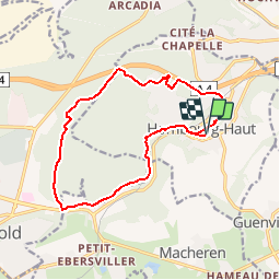
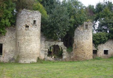
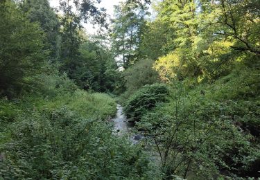
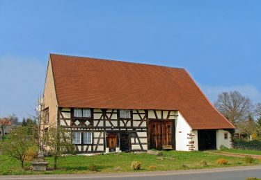
Trail Walking of 14.2 km to be discovered at Grand Est, Moselle, Hombourg-Haut. This trail is proposed by tracegps.

Description

Circuit permettant de découvrir le vieux Hombourg ainsi que quelques points de vue surprenants. Départ de la salle des fêtes, rue des Suédois.

Elevation profile

Photos

Positioning

Country:
France
Region :
Grand Est
Department/Province :
Moselle
Municipality :
Hombourg-Haut
Location:
Unknown
Start:(UTM)
337975 ; 5443678 (32U) N.

Trails nearby

Trail Walking Saint-Avold - Variente Saint Avold Papiermuhle - Photo
Walking
oger_eric

Walking

Easy
(1)
Saint-Avold, Grand Est, Moselle, France
14.8 km | 19.9 km-effort
4h 17min
Yes
Trail On foot Hombourg-Haut - Circuit de la collégiale de Hombourg-Haut - Photo
On foot
PRO

On foot

Easy
Hombourg-Haut, Grand Est, Moselle, France
12.2 km | 16.2 km-effort
3h 41min
Yes
Trail On foot Saint-Avold - Circuit du Steinberg - Photo
On foot
PRO

On foot

Easy
Saint-Avold, Grand Est, Moselle, France
7.3 km | 9.4 km-effort
2h 7min
Yes
Trail Walking Hombourg-Haut - Boucle au dessus de Hombourg - Haut  - Photo
Walking
dudu42

Walking

Medium
Hombourg-Haut, Grand Est, Moselle, France
9.8 km | 13.1 km-effort
2h 22min
Yes
Trail On foot Saint-Avold - 3 Circuit du Chene des Sorcières - Photo
On foot
PRO

On foot

Easy
Saint-Avold, Grand Est, Moselle, France
8.6 km | 11.8 km-effort
2h 40min
No
Trail Walking Saint-Avold - Eric chênes des sorcières  - Photo
Walking
oger_eric

Walking

Medium
(2)
Saint-Avold, Grand Est, Moselle, France
10.3 km | 13.6 km-effort
2h 57min
Yes
Trail Walking Saint-Avold - Eric Altviller - Photo
Walking
oger_eric

Walking

Easy
(1)
Saint-Avold, Grand Est, Moselle, France
12.4 km | 16.1 km-effort
3h 25min
No
Trail Walking Saint-Avold - Saint Avold Stephelen - Photo
Walking
oger_eric

Walking

Easy
Saint-Avold, Grand Est, Moselle, France
9.9 km | 12.5 km-effort
2h 44min
Yes
Trail On foot Guenviller - Circuit de la Nied Allemande - Photo
On foot
PRO

On foot

Easy
Guenviller, Grand Est, Moselle, France
9.7 km | 11.4 km-effort
2h 34min
No


Close
My subscriptions