Trail Walking Saumont - Le Saumont, randonnée autour du mont boisé - Photo

Le Saumont, randonnée autour du mont boisé

 tracegps
tracegps

User

© OpenStreetMap contributors
Length
Length
14.1 km
Max alt
Max alt
160 m
Uphill gradient
Uphill gradient
315 m
Km-Effort
Km-Effort  
18.3 km
Min alt
Min alt
70 m
Downhill gradient
Downhill gradient
312 m
Boucle
Boucle
Yes
Creation date :
2014-12-10 00:00:00.0
Updated on :
2014-12-10 00:00:00.0

(0 Reviews)

Walking
Walking
3h34
Difficulty : Difficult

Scan this QR Code to open this trail in the SityTrail application

FREE GPS app for hiking

Logo SityTrail SityTrail

IGN / Geographical institutes

Download SityTrail from the App Store Download SityTrail from Google Play

Logo SityTrail SityTrail World

The world is yours!

Download SityTrail from the App Store Download SityTrail from Google Play Download SityTrail on Huawei AppGallery

About

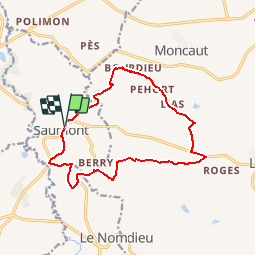
Trail Walking of 14.1 km to be discovered at New Aquitaine, Lot-et-Garonne, Saumont. This trail is proposed by tracegps.

Description

Le Saumont, de saltus montus, signifie hauteur boisée. L’itinéraire descend vers le Petit Auvignon qu’il franchit sur un Pont Roman. Il traverse ensuite un paysage ouvert de collines, typique de la Gascogne. Départ de la  mairie de Le Saumont. Téléchargez la fiche de cette randonnée sur le site du Tourisme du Lot et Garonne.

Elevation profile

Photos

Positioning

Country:
France
Region :
New Aquitaine
Department/Province :
Lot-et-Garonne
Municipality :
Saumont
Location:
Unknown
Start:(UTM)
296669 ; 4888576 (31T) N.

Trails nearby

Trail Walking Nomdieu - le Nomdieu à la découverte des cadrans solaires - Photo
Walking
Forsans

Walking

Medium
Nomdieu, New Aquitaine, Lot-et-Garonne, France
16.5 km | 19.9 km-effort
5h 48min
No
Trail On foot Nomdieu - Le Nomdieu, vers le point de vue de l'église de Saint-Lary 8.9 km - Photo
On foot
PRO

On foot

Easy
Nomdieu, New Aquitaine, Lot-et-Garonne, France
8.9 km | 10.9 km-effort
2h 29min
Yes
Trail On foot Nomdieu - Le Nomdieu, vers le point de vue de l'église de Saint-Lary variante 7.9 km - Photo
On foot
PRO

On foot

Easy
Nomdieu, New Aquitaine, Lot-et-Garonne, France
7.9 km | 9.6 km-effort
2h 11min
Yes
Trail On foot Nomdieu - Le Nomdieu, vers le point de vue de l'église de Saint-Lary variante 3.7 km - Photo
On foot
PRO

On foot

Easy
Nomdieu, New Aquitaine, Lot-et-Garonne, France
3.4 km | 4.7 km-effort
1h 3min
Yes
Trail On foot Nomdieu - Le Nomdieu, à la découverte des cadrans solaires 13.9 km - Photo
On foot
PRO

On foot

Easy
Nomdieu, New Aquitaine, Lot-et-Garonne, France
13.9 km | 17.1 km-effort
3h 52min
Yes
Trail Equestrian Montagnac-sur-Auvignon - Petite montagne d'Albret - Montagnac sur Auvignon  - Photo
Equestrian
tracegps

Equestrian

Easy
Montagnac-sur-Auvignon, New Aquitaine, Lot-et-Garonne, France
7.3 km | 10 km-effort
1h 15min
Yes
Trail Mountain bike Montagnac-sur-Auvignon - Petite montagne d'Albret - Montagnac sur Auvignon  - Photo
Mountain bike
tracegps

Mountain bike

Easy
Montagnac-sur-Auvignon, New Aquitaine, Lot-et-Garonne, France
7.3 km | 10 km-effort
55min
Yes
Trail Walking Montagnac-sur-Auvignon - Petite montagne d'Albret - Montagnac sur Auvignon  - Photo
Walking
tracegps

Walking

Medium
Montagnac-sur-Auvignon, New Aquitaine, Lot-et-Garonne, France
7.3 km | 10 km-effort
2h 30min
Yes
Trail Mountain bike Saumont - Le Saumont vers Montagnac, par les Grand et Petit Auvignon - Photo
Mountain bike
tracegps

Mountain bike

Medium
Saumont, New Aquitaine, Lot-et-Garonne, France
15.1 km | 19.6 km-effort
1h 49min
Yes


Close
My subscriptions