Trail On foot Touillon - Touillon Fontenay - Photo
 mricard
mricard

User

© OpenStreetMap contributors
Length
Length
10.9 km
Max alt
Max alt
352 m
Uphill gradient
Uphill gradient
282 m
Km-Effort
Km-Effort  
14.6 km
Min alt
Min alt
239 m
Downhill gradient
Downhill gradient
277 m
Boucle
Boucle
Yes
Creation date :
2022-03-03 17:23:43.876
Updated on :
2022-03-03 17:26:11.115

(0 Reviews)

On foot
On foot
3h05
Difficulty : Easy

Scan this QR Code to open this trail in the SityTrail application

FREE GPS app for hiking

Logo SityTrail SityTrail

IGN / Geographical institutes

Download SityTrail from the App Store Download SityTrail from Google Play

Logo SityTrail SityTrail World

The world is yours!

Download SityTrail from the App Store Download SityTrail from Google Play Download SityTrail on Huawei AppGallery

About

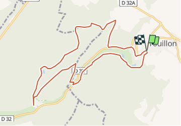
Trail On foot of 10.9 km to be discovered at Bourgogne-Franche-Comté, Côte-d'Or, Touillon. This trail is proposed by mricard.

Description

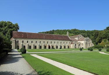
De Touillon à l'abbaye de Fontenay par le sentier découverte et la combe des Charriottes.

Elevation profile

Positioning

Country:
France
Region :
Bourgogne-Franche-Comté
Department/Province :
Côte-d'Or
Municipality :
Touillon
Location:
Unknown
Start:(UTM)
607149 ; 5278606 (31T) N.

Trails nearby

Trail On foot Marmagne - Circuit de l'Abbaye - Photo
On foot
GUIDE+

On foot

Medium
Marmagne, Bourgogne-Franche-Comté, Côte-d'Or, France
18 km | 23 km-effort
5h 18min
Yes
Trail Other activity Marmagne - fontenay - Photo
Other activity
gilles1955

Other activity

Very easy
Marmagne, Bourgogne-Franche-Comté, Côte-d'Or, France
6.8 km | 9.4 km-effort
1h 0min
Yes
Trail Walking Marmagne - Sentier des Abbeyes - Photo
Walking
danpar

Walking

Easy
Marmagne, Bourgogne-Franche-Comté, Côte-d'Or, France
96 km | 118 km-effort
24h 59min
No


Close
My subscriptions