Trail Walking Châtel - Mont de grange depuis le col de Bassachaux  - Photo

Mont de grange depuis le col de Bassachaux

© OpenStreetMap contributors
Length
Length
16.5 km
Max alt
Max alt
2408 m
Uphill gradient
Uphill gradient
1016 m
Km-Effort
Km-Effort  
30 km
Min alt
Min alt
1530 m
Downhill gradient
Downhill gradient
1015 m
Boucle
Boucle
Yes
Creation date :
2014-12-10 00:00:00.0
Updated on :
2014-12-10 00:00:00.0

(2 Reviews)

Walking
Walking
6h07
Difficulty : Difficult

Scan this QR Code to open this trail in the SityTrail application

FREE GPS app for hiking

Logo SityTrail SityTrail

IGN / Geographical institutes

Download SityTrail from the App Store Download SityTrail from Google Play

Logo SityTrail SityTrail World

The world is yours!

Download SityTrail from the App Store Download SityTrail from Google Play Download SityTrail on Huawei AppGallery

About

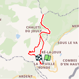
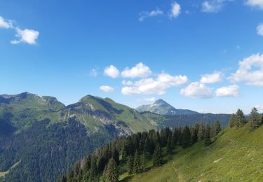
Trail Walking of 16.5 km to be discovered at Auvergne-Rhône-Alpes, Upper Savoy, Châtel. This trail is proposed by dalla.anthony.

Description

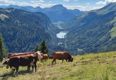
départ de la randonnée 1 km en aval du col de Bassachaux (au dessus du Pré la Joux) retour par le même chemin avec petit détour par les chalets de Lens (au niveau des Chalets de Lens, ne pas prendre la direction du col de bassachaux, indiquée sur les panneaux pour revenir, mais bien continuer jusqu'aux chalets et prendre le chemin qui monte sur la gauche derrière les chalets.
Sentier exposé plein Sud donc rando possible depuis mi mai.

Elevation profile

Photos

Points of interest

Point of interest Abondance - Point 3 - Photo
dalla.anthony
ABONDANCE 
Point of interest Châtel - Point 6 - Photo
dalla.anthony
CHÂTEL 

Positioning

Country:
France
Region :
Auvergne-Rhône-Alpes
Department/Province :
Upper Savoy
Municipality :
Châtel
Location:
Unknown
Start:(UTM)
328802 ; 5121307 (32T) N.

Comments

Please log in to post a review or rate the element


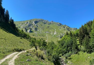
rando accessible sans passage difficile. moins de dénivelé que depuis la chapelle d'abondance.


Trails nearby

Trail Walking Morzine - d'Avoriaz aux Mines d'or par le col du Fornet et le col de Cou - Photo
Walking
ppapy

Walking

Medium
(1)
Morzine, Auvergne-Rhône-Alpes, Upper Savoy, France
9.6 km | 17.9 km-effort
3h 28min
No
Trail Walking Abondance - Le Roc de Tavaneuse 2156 m, depuis Prétairié - Photo
Walking
tracegps

Walking

Medium
(1)
Abondance, Auvergne-Rhône-Alpes, Upper Savoy, France
8.2 km | 21 km-effort
5h 30min
Yes
Trail Walking Abondance - Le Mont de Grange, 2432m - Photo
Walking
tracegps

Walking

Difficult
(1)
Abondance, Auvergne-Rhône-Alpes, Upper Savoy, France
10.9 km | 25 km-effort
7h 0min
Yes
Trail On foot Val-d'Illiez - Les Crosets-Sur Cou - Photo
On foot
PRO

On foot

Easy
Val-d'Illiez, Valais/Wallis, Monthey, Switzerland
3.6 km | 4.8 km-effort
1h 6min
No
Trail Snowshoes Châtel - Randonnée entre la France et la suisse  - Photo
Snowshoes
GUIDE
pascalou73

Snowshoes

Easy
Châtel, Auvergne-Rhône-Alpes, Upper Savoy, France
5.8 km | 8.5 km-effort
2h 3min
Yes
Trail Walking Morzine - 74-Avoriaz-cretes-belvedere-10km-360 - Photo
Walking
SyMA

Walking

Easy
Morzine, Auvergne-Rhône-Alpes, Upper Savoy, France
10 km | 14.9 km-effort
3h 1min
Yes
Trail Walking Morzine - balade des crêtes : Avoriaz . belvédère du lac de Montriond . croix des combes . Avoriaz - Photo
Walking
stef789

Walking

Medium
Morzine, Auvergne-Rhône-Alpes, Upper Savoy, France
9.9 km | 14.8 km-effort
4h 30min
Yes
Trail Walking Abondance - Col de Bassachaux le lac vert 7 juillet 2022 - Photo
Walking
med88

Walking

Very difficult
Abondance, Auvergne-Rhône-Alpes, Upper Savoy, France
13.3 km | 19.9 km-effort
3h 11min
Yes
Trail Walking Châtel - Les Mattes - Photo
Walking
mlienhart

Walking

Difficult
Châtel, Auvergne-Rhône-Alpes, Upper Savoy, France
11.1 km | 22 km-effort
5h 42min
Yes


Close
My subscriptions