Trail Mountain bike Montrozier - VTT Gages-Palanges Magalie 38km 750D+ 2021-06-19 - Photo

VTT Gages-Palanges Magalie 38km 750D+ 2021-06-19

© OpenStreetMap contributors
Length
Length
38 km
Max alt
Max alt
860 m
Uphill gradient
Uphill gradient
681 m
Km-Effort
Km-Effort  
47 km
Min alt
Min alt
551 m
Downhill gradient
Downhill gradient
680 m
Boucle
Boucle
Yes
Creation date :
2021-12-23 15:33:16.672
Updated on :
2021-12-23 15:35:58.369

(0 Reviews)

Mountain bike
Mountain bike
--
Difficulty : Medium

Scan this QR Code to open this trail in the SityTrail application

FREE GPS app for hiking

Logo SityTrail SityTrail

IGN / Geographical institutes

Download SityTrail from the App Store Download SityTrail from Google Play

Logo SityTrail SityTrail World

The world is yours!

Download SityTrail from the App Store Download SityTrail from Google Play Download SityTrail on Huawei AppGallery

About

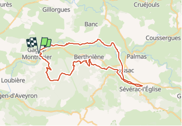
Trail Mountain bike of 38 km to be discovered at Occitania, Aveyron, Montrozier. This trail is proposed by Levillefranchois.

Description

Parcours très agréable dans l'ensemble et même ludique dans la forêt des Palanges

Elevation profile

Positioning

Country:
France
Region :
Occitania
Department/Province :
Aveyron
Municipality :
Montrozier
Location:
Unknown
Start:(UTM)
476767 ; 4916051 (31T) N.

Trails nearby

Trail Walking Bozouls - Horizons et Clochers du Rouergue - Gillorgues - Photo
Walking
tracegps

Walking

Medium
Bozouls, Occitania, Aveyron, France
11.9 km | 15.5 km-effort
3h 0min
Yes
Trail Moto cross Montrozier - av cl 2024 - Photo
Moto cross
frank12

Moto cross

Very easy
Montrozier, Occitania, Aveyron, France
30 km | 42 km-effort
1h 0min
No
Trail Walking Montrozier - Gages Campeyroux - Photo
Walking
Rere1947

Walking

Montrozier, Occitania, Aveyron, France
8.4 km | 9.7 km-effort
1h 52min
Yes
Trail Walking Bozouls - Gillorgues - Photo
Walking
Lacaze

Walking

Medium
Bozouls, Occitania, Aveyron, France
10.9 km | 14.1 km-effort
3h 11min
Yes
Trail Walking Montrozier - causse comtal - Photo
Walking
Lacaze

Walking

Easy
Montrozier, Occitania, Aveyron, France
7 km | 8.1 km-effort
1h 46min
Yes
Trail Mountain bike Bozouls - Aboul - Photo
Mountain bike
bonnetchristian

Mountain bike

Very easy
Bozouls, Occitania, Aveyron, France
5.4 km | 6.9 km-effort
Unknown
Yes
Trail Mountain bike Montrozier - La Combe - Photo
Mountain bike
bonnetchristian

Mountain bike

Very easy
Montrozier, Occitania, Aveyron, France
4.5 km | 5.4 km-effort
Unknown
Yes
Trail Mountain bike Montrozier - Gages - Photo
Mountain bike
bonnetchristian

Mountain bike

Very easy
Montrozier, Occitania, Aveyron, France
4.7 km | 6 km-effort
Unknown
Yes
Trail Mountain bike Bozouls - Route de César - Photo
Mountain bike
bonnetchristian

Mountain bike

Very easy
Bozouls, Occitania, Aveyron, France
6.7 km | 8.4 km-effort
Unknown
Yes


Close
My subscriptions