Trail Walking Avesnes-les-Aubert - Avesnes les Aubert. tour de la ville par St Aubert - Photo

Avesnes les Aubert. tour de la ville par St Aubert

 papiou
papiou

User

© OpenStreetMap contributors
Length
Length
10 km
Max alt
Max alt
89 m
Uphill gradient
Uphill gradient
82 m
Km-Effort
Km-Effort  
11.1 km
Min alt
Min alt
56 m
Downhill gradient
Downhill gradient
83 m
Boucle
Boucle
Yes
Creation date :
2021-11-07 08:00:35.809
Updated on :
2021-11-07 14:34:50.836

(0 Reviews)

Walking
Walking
2h00
Difficulty : Medium

Scan this QR Code to open this trail in the SityTrail application

FREE GPS app for hiking

Logo SityTrail SityTrail

IGN / Geographical institutes

Download SityTrail from the App Store Download SityTrail from Google Play

Logo SityTrail SityTrail World

The world is yours!

Download SityTrail from the App Store Download SityTrail from Google Play Download SityTrail on Huawei AppGallery

About

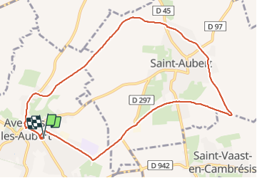
Trail Walking of 10 km to be discovered at Hauts-de-France, Nord, Avesnes-les-Aubert. This trail is proposed by papiou.

Description

rdv parking Mairie, partir par rue Barbusse vers le haut pour rejoindre D297 puis dans un virage prendre le chemin tout droit. au bout D45 faire un droite- gauche et continuer jusqu'à un carrefour pour prendre à gauche chemin catelot pour rejoindre rue Jaurès et Villars puis rue du cateau et à la D45, droite et gauche Chemin pour rejoindre D74 rue Karl Marx pour revenir au départ.

Elevation profile

Positioning

Country:
France
Region :
Hauts-de-France
Department/Province :
Nord
Municipality :
Avesnes-les-Aubert
Location:
Unknown
Start:(UTM)
527267 ; 5560542 (31U) N.

Trails nearby

Trail Walking Saulzoir - Circuit de la vallée des Saules -  Saulzoir - Photo
Walking
tracegps

Walking

Medium
(1)
Saulzoir, Hauts-de-France, Nord, France
9.9 km | 11.1 km-effort
2h 30min
Yes
Trail Walking Carnières - Circuit des 2 tours - Carnières - Photo
Walking
tracegps

Walking

Medium
Carnières, Hauts-de-France, Nord, France
10.6 km | 11.8 km-effort
2h 40min
Yes
Trail Cycle Carnières - Les Mulquiniers: Pays des Riots - Photo
Cycle
tracegps

Cycle

Medium
Carnières, Hauts-de-France, Nord, France
36 km | 40 km-effort
2h 30min
Yes
Trail Walking Iwuy - Iwuy Thun par le Canal - Photo
Walking
BrassensJC

Walking

Medium
Iwuy, Hauts-de-France, Nord, France
8 km | 8.5 km-effort
1h 53min
Yes
Trail Walking Villers-en-Cauchies - Parcours du coeur - Photo
Walking
doryphore

Walking

Very easy
Villers-en-Cauchies, Hauts-de-France, Nord, France
11.8 km | 12.9 km-effort
2h 0min
Yes
Trail On foot Iwuy - Le tour d'Iwuy - Photo
On foot
BrassensJC

On foot

Very easy
Iwuy, Hauts-de-France, Nord, France
6.1 km | 6.6 km-effort
Unknown
Yes
Trail Walking Saint-Vaast-en-Cambrésis - Tour de St Vaast en Cambraisis  - Photo
Walking
BRASSENS

Walking

Easy
Saint-Vaast-en-Cambrésis, Hauts-de-France, Nord, France
9.2 km | 10.2 km-effort
2h 8min
Yes
Trail Walking Saint-Vaast-en-Cambrésis - Boucle autour de St Vaast en C - Photo
Walking
BrassensJC

Walking

Easy
Saint-Vaast-en-Cambrésis, Hauts-de-France, Nord, France
7.9 km | 8.8 km-effort
1h 57min
Yes
Trail Cycle Villers-en-Cauchies - Course cycliste de Villers en Cauchies - Photo
Cycle
doryphore

Cycle

Easy
Villers-en-Cauchies, Hauts-de-France, Nord, France
9.1 km | 10.1 km-effort
35min
Yes


Close
My subscriptions