Trail Walking Lerné - Lerné La devinière - Photo
© OpenStreetMap contributors
Length
Length
14 km
Max alt
Max alt
116 m
Uphill gradient
Uphill gradient
150 m
Km-Effort
Km-Effort  
16 km
Min alt
Min alt
56 m
Downhill gradient
Downhill gradient
150 m
Boucle
Boucle
Yes
Creation date :
2021-11-05 14:21:21.796
Updated on :
2021-11-05 14:31:09.438

(0 Reviews)

Walking
Walking
3h37
Difficulty : Difficult

Scan this QR Code to open this trail in the SityTrail application

FREE GPS app for hiking

Logo SityTrail SityTrail

IGN / Geographical institutes

Download SityTrail from the App Store Download SityTrail from Google Play

Logo SityTrail SityTrail World

The world is yours!

Download SityTrail from the App Store Download SityTrail from Google Play Download SityTrail on Huawei AppGallery

About

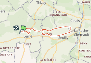
Trail Walking of 14 km to be discovered at Centre-Loire Valley, Indre-et-Loire, Lerné. This trail is proposed by Gîte Pic Epeiche.

Description

Départ du Gîte Pic Epeiche, ballade en forêt au dessus de Lerné puis sur les plateaux au dessus de Seuilly pour arrivée à la Devinière, Maison natale de Rabelais, retour par le Coteaux de Seuilly et par le bourg de lerné

Elevation profile

Photos

Positioning

Country:
France
Region :
Centre-Loire Valley
Department/Province :
Indre-et-Loire
Municipality :
Lerné
Location:
Unknown
Start:(UTM)
281008 ; 5224525 (31T) N.

Trails nearby

Trail Walking Fontevraud-l'Abbaye - Tracé_23-JUIN-23 125458 - Photo
Walking
rigol05

Walking

Medium
Fontevraud-l'Abbaye, Pays de la Loire, Maine-et-Loire, France
9.2 km | 11.3 km-effort
2h 33min
Yes
Trail Walking Fontevraud-l'Abbaye - Fontevraud: le bourg, la forêt - Photo
Walking
JMCMoreau

Walking

Easy
Fontevraud-l'Abbaye, Pays de la Loire, Maine-et-Loire, France
8.5 km | 10.3 km-effort
3h 0min
Yes
Trail Walking Lerné - Boucle de Lerné à Seuilly - Photo
Walking
JMCMoreau

Walking

Easy
Lerné, Centre-Loire Valley, Indre-et-Loire, France
12.1 km | 13.6 km-effort
3h 30min
Yes
Trail Walking Saint-Germain-sur-Vienne - st germain  sur vienne - Photo
Walking
tnayurb

Walking

Medium
Saint-Germain-sur-Vienne, Centre-Loire Valley, Indre-et-Loire, France
8.3 km | 9.9 km-effort
2h 15min
Yes
Trail Walking Fontevraud-l'Abbaye - Autour de Fontevraud L'abbaye - Photo
Walking
maupassant38

Walking

Easy
Fontevraud-l'Abbaye, Pays de la Loire, Maine-et-Loire, France
8.5 km | 10.3 km-effort
1h 47min
No
Trail Walking Saint-Germain-sur-Vienne - St-Germain-sur-Vienne - 20.3km 280m 4h30 - 2018 05 06 - Photo
Walking
Orcal37

Walking

Easy
Saint-Germain-sur-Vienne, Centre-Loire Valley, Indre-et-Loire, France
20 km | 24 km-effort
4h 30min
Yes
Trail Nordic walking Saint-Germain-sur-Vienne - Le petit Thouars-chaumine - Photo
Nordic walking
laoj

Nordic walking

Easy
Saint-Germain-sur-Vienne, Centre-Loire Valley, Indre-et-Loire, France
3.3 km | 4.2 km-effort
40min
No
Trail Mountain bike Fontevraud-l'Abbaye - LE CLOS GUÉ - Photo
Mountain bike
laoj

Mountain bike

Easy
Fontevraud-l'Abbaye, Pays de la Loire, Maine-et-Loire, France
18.8 km | 23 km-effort
1h 29min
Yes
Trail Mountain bike Fontevraud-l'Abbaye -  LE GR 3 DE LA PONIÉRE - Photo
Mountain bike
laoj

Mountain bike

Medium
Fontevraud-l'Abbaye, Pays de la Loire, Maine-et-Loire, France
15.1 km | 18.3 km-effort
1h 12min
Yes


Close
My subscriptions