Trail Walking Sigonce - Sigonce-la Blondine au Prieuré de Ganagobie - Photo

Sigonce-la Blondine au Prieuré de Ganagobie

 JPJ38
JPJ38

User

© OpenStreetMap contributors
Length
Length
7.7 km
Max alt
Max alt
708 m
Uphill gradient
Uphill gradient
339 m
Km-Effort
Km-Effort  
11.6 km
Min alt
Min alt
494 m
Downhill gradient
Downhill gradient
140 m
Boucle
Boucle
No
Creation date :
2021-09-02 19:51:05.214
Updated on :
2021-09-11 17:40:14.678

(0 Reviews)

Walking
Walking
2h13
Difficulty : Medium

Scan this QR Code to open this trail in the SityTrail application

FREE GPS app for hiking

Logo SityTrail SityTrail

IGN / Geographical institutes

Download SityTrail from the App Store Download SityTrail from Google Play

Logo SityTrail SityTrail World

The world is yours!

Download SityTrail from the App Store Download SityTrail from Google Play Download SityTrail on Huawei AppGallery

About

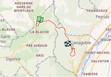
Trail Walking of 7.7 km to be discovered at Provence-Alpes-Côte d'Azur, Alpes-de-Haute-Provence, Sigonce. This trail is proposed by JPJ38.

Description

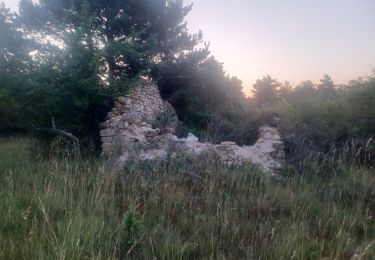
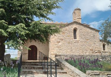
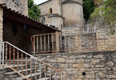
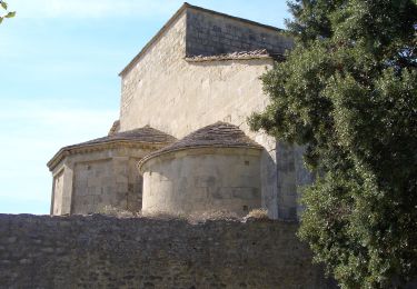
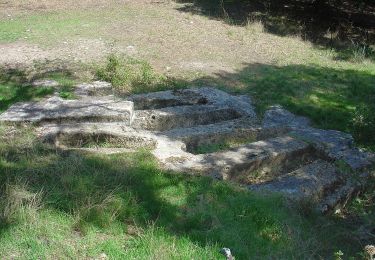
A l'arrivée sur le plateau de Ganagobie aller jusqu'au prieuré puis longer l'autre bord du plateau pour passer par les ruines de la vieille ville puis terminer la boucle  au point culminant de l'aller et retour par le même parcours par l'aller. distance totale 14km

Elevation profile

Positioning

Country:
France
Region :
Provence-Alpes-Côte d'Azur
Department/Province :
Alpes-de-Haute-Provence
Municipality :
Sigonce
Location:
Unknown
Start:(UTM)
729745 ; 4878351 (31T) N.

Trails nearby

Trail Walking Ganagobie - Plateau de Ganagobie - Photo
Walking
tracegps

Walking

Medium
(2)
Ganagobie, Provence-Alpes-Côte d'Azur, Alpes-de-Haute-Provence, France
7.6 km | 10.9 km-effort
3h 0min
Yes
Trail Walking Montlaux - montlaux.lablache - Photo
Walking
Roger

Walking

Medium
Montlaux, Provence-Alpes-Côte d'Azur, Alpes-de-Haute-Provence, France
8.4 km | 11.8 km-effort
3h 6min
Yes
Trail Walking Ganagobie - 2024-02-27 Ganagobie  - Photo
Walking
GUIDE
Kargil

Walking

Easy
Ganagobie, Provence-Alpes-Côte d'Azur, Alpes-de-Haute-Provence, France
10.2 km | 15.1 km-effort
3h 25min
Yes
Trail Walking Cruis - cruis la ronde des jas . - Photo
Walking
Roger

Walking

Medium
Cruis, Provence-Alpes-Côte d'Azur, Alpes-de-Haute-Provence, France
11.4 km | 18.1 km-effort
3h 39min
Yes
Trail Walking Cruis - CRUIS . L ESPINASSE . DEFEND DES BOEUF . JAS ROCHE . O S L - Photo
Walking
RobinMicheline

Walking

Medium
Cruis, Provence-Alpes-Côte d'Azur, Alpes-de-Haute-Provence, France
13 km | 19.9 km-effort
3h 29min
Yes
Trail Walking Revest-Saint-Martin - Le revest 04.la  blache 04 - Photo
Walking
Roger

Walking

Very easy
Revest-Saint-Martin, Provence-Alpes-Côte d'Azur, Alpes-de-Haute-Provence, France
4.5 km | 5.5 km-effort
2h 8min
Yes
Trail Walking Mallefougasse-Augès - col Bas depuis mallefougasse - Photo
Walking
Roger

Walking

Medium
Mallefougasse-Augès, Provence-Alpes-Côte d'Azur, Alpes-de-Haute-Provence, France
9.2 km | 12.4 km-effort
3h 1min
Yes
Trail On foot Ganagobie - PR - Photo
On foot
PRO

On foot

Easy
Ganagobie, Provence-Alpes-Côte d'Azur, Alpes-de-Haute-Provence, France
3.6 km | 5.8 km-effort
1h 19min
No
Trail On foot Ganagobie - La Forêt du Prieuré - Photo
On foot
PRO

On foot

Easy
Ganagobie, Provence-Alpes-Côte d'Azur, Alpes-de-Haute-Provence, France
10.2 km | 15.3 km-effort
3h 28min
No


Close
My subscriptions