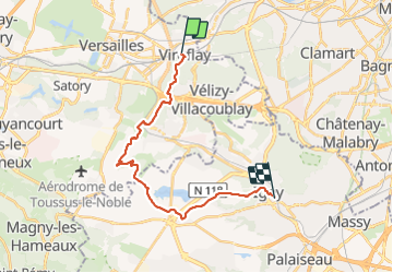
23 km | 31 km-effort
Le plateau de Saclay, de Viroflay à Igny
c.chehere
User
Length
19.5 km
Max alt
187 m
Uphill gradient
254 m
Km-Effort
23 km
Min alt
73 m
Downhill gradient
299 m
Boucle
No
Creation date :
2021-07-31 06:41:00.94
Updated on :
2021-07-31 13:28:06.983
5h36
Difficulty : Easy
FREE GPS app for hiking
About
Trail Walking of 19.5 km to be discovered at Ile-de-France, Yvelines, Viroflay. This trail is proposed by c.chehere.
Description
De Viroflay RD à la Gare d'Igny.
Positioning
Country:
France
Region :
Ile-de-France
Department/Province :
Yvelines
Municipality :
Viroflay
Location:
Unknown
Start:(Dec)
Start:(UTM)
439175 ; 5405530 (31U) N.
Comments
Trails nearby
Le Sentier des 7 étangs
Walking
Difficult
(5)
Chaville,
Ile-de-France,
Hauts-de-Seine,
France
5h 0min
Yes
GRP CV-IDF 20R Chaville à Vaucresson
Walking
Medium
(1)
Chaville,
Ile-de-France,
Hauts-de-Seine,
France
8.2 km | 11.1 km-effort
2h 30min
No
GRP CV-IDF 2023
Walking
Difficult
(1)
Jouy-en-Josas,
Ile-de-France,
Yvelines,
France
11.2 km | 14.5 km-effort
3h 17min
No
Les 3 Forêts; Meudon, Fausses Reposes et Versailles
Walking
Difficult
(2)
Viroflay,
Ile-de-France,
Yvelines,
France
25 km | 32 km-effort
5h 19min
Yes
Sentier des deux Forêts - Meudon et Verrières
Walking
Difficult
(2)
Chaville,
Ile-de-France,
Hauts-de-Seine,
France
23 km | 29 km-effort
5h 0min
Yes
Le Tour de Satory
Walking
Difficult
(2)
Buc,
Ile-de-France,
Yvelines,
France
23 km | 28 km-effort
4h 49min
Yes
Parc de St Cloud et forêt de Fausses Reposes
Walking
Medium
(1)
Boulogne-Billancourt,
Ile-de-France,
Hauts-de-Seine,
France
18.2 km | 23 km-effort
4h 30min
No
Tour des etangs - Bois de Clamart et de Meudon
Walking
Easy
Clamart,
Ile-de-France,
Hauts-de-Seine,
France
8 km | 9.9 km-effort
2h 16min
Yes
Parc de Versailles
Other activity
Very easy
(1)
Versailles,
Ile-de-France,
Yvelines,
France
8.9 km | 9.7 km-effort
1h 49min
Yes