Trail On foot Conques-sur-Orbiel - Conques-Les Capitelles - Photo

Conques-Les Capitelles

 dufland
dufland

User

© OpenStreetMap contributors
Length
Length
6.4 km
Max alt
Max alt
248 m
Uphill gradient
Uphill gradient
94 m
Km-Effort
Km-Effort  
7.7 km
Min alt
Min alt
189 m
Downhill gradient
Downhill gradient
99 m
Boucle
Boucle
Yes
Creation date :
2021-04-14 20:29:35.611
Updated on :
2021-04-15 15:03:28.784

(2 Reviews)

On foot
On foot
2h30
Difficulty : Easy

Scan this QR Code to open this trail in the SityTrail application

FREE GPS app for hiking

Logo SityTrail SityTrail

IGN / Geographical institutes

Download SityTrail from the App Store Download SityTrail from Google Play

Logo SityTrail SityTrail World

The world is yours!

Download SityTrail from the App Store Download SityTrail from Google Play Download SityTrail on Huawei AppGallery

About

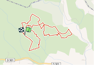
Trail On foot of 6.4 km to be discovered at Occitania, Aude, Conques-sur-Orbiel. This trail is proposed by dufland.

Description

Cumul des 3 circuits bleu, vert, rose,

Elevation profile

Positioning

Country:
France
Region :
Occitania
Department/Province :
Aude
Municipality :
Conques-sur-Orbiel
Location:
Unknown
Start:(UTM)
448977 ; 4793503 (31T) N.

Comments

Please log in to post a review or rate the element


très agréable


Trails nearby

Trail Walking Villardonnel - Balade autour de Gleyre - Villardonnel - Photo
Walking
tracegps

Walking

Medium
(1)
Villardonnel, Occitania, Aude, France
6.4 km | 9.4 km-effort
2h 30min
Yes
Trail Walking Aragon - GARILLE - FONT DE L'ORME - GARILLE - Photo
Walking
Combaut11

Walking

Medium
(1)
Aragon, Occitania, Aude, France
6 km | 7.4 km-effort
1h 41min
Yes
Trail Walking Villegailhenc - Villegailhenc Conques Aragon - Photo
Walking
GUIDE
Ada11

Walking

Medium
Villegailhenc, Occitania, Aude, France
23 km | 29 km-effort
5h 45min
Yes
Trail Walking Conques-sur-Orbiel - village celte - Photo
Walking
oliviercaty

Walking

Easy
(1)
Conques-sur-Orbiel, Occitania, Aude, France
3.9 km | 4.8 km-effort
1h 48min
Yes
Trail Walking Lastours - Lastours dans l'Aude et ses tours... - Photo
Walking
tracegps

Walking

Easy
(1)
Lastours, Occitania, Aude, France
2.8 km | 4.2 km-effort
2h 0min
Yes
Trail Walking Sallèles-Cabardès - Sallèles Cabardès - Pradellles Cabardès - Pic du Nore-   - Photo
Walking
jacques delaporte

Walking

Very difficult
Sallèles-Cabardès, Occitania, Aude, France
65 km | 0 m-effort
23h 36min
Yes
Trail Walking Sallèles-Cabardès - Reco Le Pic de Nore  - Photo
Walking
jacques delaporte

Walking

Very difficult
Sallèles-Cabardès, Occitania, Aude, France
54 km | 79 km-effort
21h 27min
Yes
Trail Walking Conques-sur-Orbiel - les capitales à Conques - Photo
Walking
bernardbelmas

Walking

Easy
Conques-sur-Orbiel, Occitania, Aude, France
4.3 km | 5.2 km-effort
1h 36min
Yes
Trail Walking Lastours - Châteaux de Lastours 27-03-2022 - Photo
Walking
fredetpascale

Walking

Easy
Lastours, Occitania, Aude, France
4.1 km | 6 km-effort
1h 30min
Yes


Close
My subscriptions