Trail Canoe - kayak Florenville - Etape 2 - Samedi : Chassepierre-Herbeumont Kayak - Photo

Etape 2 - Samedi : Chassepierre-Herbeumont Kayak

© OpenStreetMap contributors
Length
Length
11.6 km
Max alt
Max alt
297 m
Uphill gradient
Uphill gradient
122 m
Km-Effort
Km-Effort  
13.2 km
Min alt
Min alt
265 m
Downhill gradient
Downhill gradient
125 m
Boucle
Boucle
No
Creation date :
2021-04-11 11:35:06.687
Updated on :
2021-04-11 20:45:36.52

(0 Reviews)

Canoe - kayak
Canoe - kayak
--
Difficulty : Very easy

Scan this QR Code to open this trail in the SityTrail application

FREE GPS app for hiking

Logo SityTrail SityTrail

IGN / Geographical institutes

Download SityTrail from the App Store Download SityTrail from Google Play

Logo SityTrail SityTrail World

The world is yours!

Download SityTrail from the App Store Download SityTrail from Google Play Download SityTrail on Huawei AppGallery

About

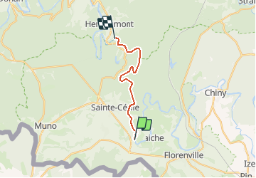
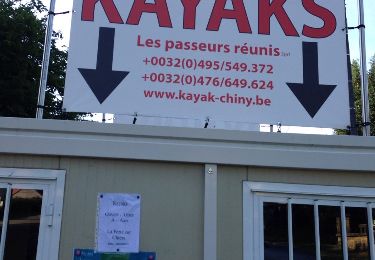
Trail Canoe - kayak of 11.6 km to be discovered at Wallonia, Luxembourg, Florenville. This trail is proposed by francoisbouchat.

Description

1.Un arrêt est recommandé à 2 km en aval de Chassepierre, aire «Conry » (accès malaisé en voiture, camping de Sainte-Cécile, privé) avant une étape de 10 km en forêt sans aire de débarquement.

2. 4,5 km en aval de l’aire « Conry », le barrage de la Vanne des Moines peut être franchi en portant (prudent) ou en se mouillant (sportif). Pour franchir en navigant, emprunter la passe aménagée à l’extrémité droite du barrage (à environ 2 mètres de la rive, repérage impératif) ; c’est le passage le plus à droite qui est utilisé, la partie gauche de la passe, trop raide, ne convient pas (risque de chavirage et danger du fait des blocs de béton au fond de l’eau).

3. Encore un méandre et à la sortie de celui-ci, un ancien barrage doit être à nouveau franchi : passage à repérer selon le niveau d’eau, généralement plus aisé sur la droite.

4. A 150 mètres en aval du barrage, en rive droite, aire de « Champ le Monde » (accostage délicat, rochers, blocs de béton, branches, manœuvre malaisée, pas de parking).

Elevation profile

Positioning

Country:
Belgium
Region :
Wallonia
Department/Province :
Luxembourg
Municipality :
Florenville
Location:
Chassepierre
Start:(UTM)
663132 ; 5508757 (31U) N.

Trails nearby

Trail Walking Florenville - RB-Lu-19_Chameleux_via-racc-2 - Photo
Walking
PRO

Walking

Very easy
(2)
Florenville, Wallonia, Luxembourg, Belgium
18 km | 22 km-effort
4h 43min
Yes
Trail Walking Florenville - RB-LUX-14 _ Dans les méandres de la Semois - Photo
Walking
PRO

Walking

Medium
(3)
Florenville, Wallonia, Luxembourg, Belgium
24 km | 31 km-effort
6h 8min
Yes
Trail Walking Chiny - Semois, rochers et étangs - Photo
Walking
Vagabond gaumardennais

Walking

Difficult
(2)
Chiny, Wallonia, Luxembourg, Belgium
14.8 km | 19.4 km-effort
2h 41min
Yes
Trail Walking Florenville - 14km St Cécile vers Herbeumont  - Photo
Walking
Dom62

Walking

Medium
(1)
Florenville, Wallonia, Luxembourg, Belgium
14 km | 18.1 km-effort
2h 56min
Yes
Trail Walking Chiny - Le long de la semois et sur les crêtes de Chiny - Photo
Walking
antoinebaetsle

Walking

Very easy
(1)
Chiny, Wallonia, Luxembourg, Belgium
6.7 km | 8.3 km-effort
1h 53min
Yes
Trail Walking Chiny - wandeling chiny - Photo
Walking
luc.delouw

Walking

Very easy
(2)
Chiny, Wallonia, Luxembourg, Belgium
7.4 km | 9.5 km-effort
1h 41min
Yes
Trail Trail Florenville - Trail Gourmand - Photo
Trail
Math007

Trail

Medium
(2)
Florenville, Wallonia, Luxembourg, Belgium
15.3 km | 21 km-effort
Unknown
Yes
Trail Walking Florenville - RB-Lu-19_Chameleux_via-racc-1 - Photo
Walking
PRO

Walking

Very easy
(1)
Florenville, Wallonia, Luxembourg, Belgium
12.6 km | 16.3 km-effort
3h 32min
Yes
Trail On foot Chiny - 25 Lacuisine - Rocher du Hât - Photo
On foot
PRO

On foot

Easy
(2)
Chiny, Wallonia, Luxembourg, Belgium
4.2 km | 5.4 km-effort
1h 13min
Yes


Close
My subscriptions