Trail Walking Maurecourt - Maurecourt - Photo
© OpenStreetMap contributors
Length
Length
7.7 km
Max alt
Max alt
182 m
Uphill gradient
Uphill gradient
165 m
Km-Effort
Km-Effort  
9.9 km
Min alt
Min alt
27 m
Downhill gradient
Downhill gradient
168 m
Boucle
Boucle
Yes
Creation date :
2021-01-22 12:51:15.991
Updated on :
2021-01-22 15:15:13.477

(1 Reviews)

Walking
Walking
2h23
Difficulty : Very easy

Scan this QR Code to open this trail in the SityTrail application

FREE GPS app for hiking

Logo SityTrail SityTrail

IGN / Geographical institutes

Download SityTrail from the App Store Download SityTrail from Google Play

Logo SityTrail SityTrail World

The world is yours!

Download SityTrail from the App Store Download SityTrail from Google Play Download SityTrail on Huawei AppGallery

About

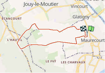
Trail Walking of 7.7 km to be discovered at Ile-de-France, Yvelines, Maurecourt. This trail is proposed by Daniel Gagner.

Description

Balade

Elevation profile

Positioning

Country:
France
Region :
Ile-de-France
Department/Province :
Yvelines
Municipality :
Maurecourt
Location:
Unknown
Start:(UTM)
431168 ; 5427822 (31U) N.

Comments

Please log in to post a review or rate the element


Très chouette balade, mais au début ça grimpe pas mal donc poussette en enfants petit pas possible. A refaire dans le sens inverse


Trails nearby

Trail Walking Jouy-le-Moutier - GRP CV-IDF 2023 - Photo
Walking
clalaur

Walking

Difficult
(1)
Jouy-le-Moutier, Ile-de-France, Val-d'Oise, France
15.6 km | 18 km-effort
4h 4min
No
Trail Walking Saint-Germain-en-Laye - GRP CV-IDF 2023 - Photo
Walking
clalaur

Walking

Very difficult
(1)
Saint-Germain-en-Laye, Ile-de-France, Yvelines, France
16.5 km | 19.1 km-effort
4h 21min
No
Trail Running Cergy - Les Bords de l'Oise et la Passerelle de l'Axe Majeur - Port Cergy - Photo
Running
tracegps

Running

Easy
(1)
Cergy, Ile-de-France, Val-d'Oise, France
5.2 km | 5.8 km-effort
30min
Yes
Trail On foot Cergy - LES BALADES DE L’ÉTÉ # 9 / DE L’AXE MAJEUR À PORT CERGY - Photo
On foot
Vadim

On foot

Very easy
(1)
Cergy, Ile-de-France, Val-d'Oise, France
6 km | 7.4 km-effort
1h 45min
Yes
Trail Walking Saint-Germain-en-Laye - D'Achères Grand Cormier à Maison Laffitte - Photo
Walking
tracegps

Walking

Medium
(1)
Saint-Germain-en-Laye, Ile-de-France, Yvelines, France
12.9 km | 14.4 km-effort
3h 0min
No
Trail On foot Cergy - Le Fil d'Ariane - Photo
On foot
PRO

On foot

Easy
Cergy, Ile-de-France, Val-d'Oise, France
3.2 km | 3.7 km-effort
50min
No
Trail On foot Cergy - Bords d'Oise Eragny - Port Cergy - Photo
On foot
Vadim

On foot

Very easy
(1)
Cergy, Ile-de-France, Val-d'Oise, France
8 km | 8.7 km-effort
2h 0min
Yes
Trail Walking Neuville-sur-Oise - base losir cergy  - Photo
Walking
bertrandgeffroy

Walking

Medium
(1)
Neuville-sur-Oise, Ile-de-France, Val-d'Oise, France
22 km | 26 km-effort
5h 35min
No
Trail Walking Triel-sur-Seine - Triel sur Seine - Photo
Walking
tbrunet

Walking

Very easy
Triel-sur-Seine, Ile-de-France, Yvelines, France
5.8 km | 6.4 km-effort
1h 47min
Yes


Close
My subscriptions