Trail Walking Petite-Rivière-Saint-François - Gabrielle-Roy EST - Photo
© OpenStreetMap contributors
Length
Length
12.1 km
Max alt
Max alt
713 m
Uphill gradient
Uphill gradient
562 m
Km-Effort
Km-Effort  
19.5 km
Min alt
Min alt
423 m
Downhill gradient
Downhill gradient
561 m
Boucle
Boucle
Yes
Creation date :
2020-09-06 13:02:56.0
Updated on :
2020-09-09 12:04:42.014

(1 Reviews)

Walking
Walking
4h42
Difficulty : Difficult

Scan this QR Code to open this trail in the SityTrail application

FREE GPS app for hiking

Logo SityTrail SityTrail

IGN / Geographical institutes

Download SityTrail from the App Store Download SityTrail from Google Play

Logo SityTrail SityTrail World

The world is yours!

Download SityTrail from the App Store Download SityTrail from Google Play Download SityTrail on Huawei AppGallery

About

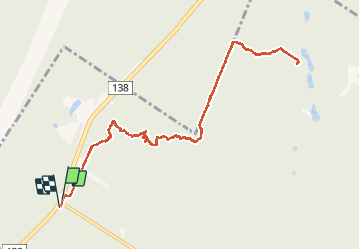
Trail Walking of 12.1 km to be discovered at Quebec, Charlevoix, Petite-Rivière-Saint-François. This trail is proposed by Tommy Blackburn.

Description

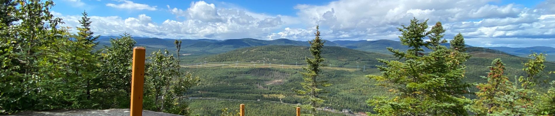
Très beau sentier en pleine foret avec de magnifique point de vue sur le fleuve et les environs.

Elevation profile

Photos

Positioning

Country:
Canada
Region :
Quebec
Department/Province :
Charlevoix
Municipality :
Petite-Rivière-Saint-François
Location:
Unknown
Start:(UTM)
379363 ; 5247485 (19T) N.

Comments

Please log in to post a review or rate the element


Merci pour le partage de cette randonnée.


Trails nearby

Trail Road bike L'Isle-aux-Coudres - Trail Planner Map - Photo
Road bike
GUIDE
Alizée.pee

Road bike

Medium
L'Isle-aux-Coudres, Quebec, Charlevoix, Canada
24 km | 28 km-effort
1h 37min
Yes
Trail Walking Baie-Saint-Paul - Rando Baie-Saint-Paul Québec - Photo
Walking
TRIMAILLE

Walking

Easy
Baie-Saint-Paul, Quebec, Charlevoix, Canada
3 km | 3.3 km-effort
43min
No


Close
My subscriptions