Trail Walking Lageon - Lageon - Photo
 mj79
mj79

User

© OpenStreetMap contributors
Length
Length
10.7 km
Max alt
Max alt
161 m
Uphill gradient
Uphill gradient
82 m
Km-Effort
Km-Effort  
11.8 km
Min alt
Min alt
119 m
Downhill gradient
Downhill gradient
83 m
Boucle
Boucle
Yes
Creation date :
2014-12-10 00:00:00.0
Updated on :
2014-12-10 00:00:00.0

(0 Reviews)

Walking
Walking
2h39
Difficulty : Very easy

Scan this QR Code to open this trail in the SityTrail application

FREE GPS app for hiking

Logo SityTrail SityTrail

IGN / Geographical institutes

Download SityTrail from the App Store Download SityTrail from Google Play

Logo SityTrail SityTrail World

The world is yours!

Download SityTrail from the App Store Download SityTrail from Google Play Download SityTrail on Huawei AppGallery

About

Trail Walking of 10.7 km to be discovered at New Aquitaine, Deux-Sèvres, Lageon. This trail is proposed by mj79.

Description

Départ parking de l'église Vous découvrirez des fermes au nom bizarre: Réussi, le Curieux, Ratil et des panneaux vous indiqueront: l'Essai, le Temps, le Contretemps, Avec; mais aucun indice pour l'Interrogateur. Une phrase interrogative se cache dans ces huit noms de fermes. A vous de retrouver la question du propriétaire facétieux des terrains: le maître du four à chaux d'Airvault

Elevation profile

Positioning

Country:
France
Region :
New Aquitaine
Department/Province :
Deux-Sèvres
Municipality :
Lageon
Location:
Unknown
Start:(UTM)
711146 ; 5179214 (30T) N.

Trails nearby

Trail Walking Lageon - lageon - Photo
Walking
mj79

Walking

Very easy
Lageon, New Aquitaine, Deux-Sèvres, France
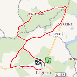
10.7 km | 11.8 km-effort
2h 39min
Yes


Close
My subscriptions