Trail On foot Lauw - Temps Libre 03/2020 Lauw - Oberen Grambaechle - Masevaux - Lac Bleu et retour - Photo

Temps Libre 03/2020 Lauw - Oberen Grambaechle - Masevaux - Lac Bleu et retour

© OpenStreetMap contributors
Length
Length
10.9 km
Max alt
Max alt
640 m
Uphill gradient
Uphill gradient
358 m
Km-Effort
Km-Effort  
15.7 km
Min alt
Min alt
378 m
Downhill gradient
Downhill gradient
358 m
Boucle
Boucle
Yes
Creation date :
2020-02-10 16:48:58.471
Updated on :
2020-03-09 06:27:20.13

(0 Reviews)

On foot
On foot
--
Difficulty : Medium

Scan this QR Code to open this trail in the SityTrail application

FREE GPS app for hiking

Logo SityTrail SityTrail

IGN / Geographical institutes

Download SityTrail from the App Store Download SityTrail from Google Play

Logo SityTrail SityTrail World

The world is yours!

Download SityTrail from the App Store Download SityTrail from Google Play Download SityTrail on Huawei AppGallery

About

Trail On foot of 10.9 km to be discovered at Grand Est, Haut-Rhin, Lauw. This trail is proposed by patrickbeyrath.

Description

Parking stade de football de Lauw - Lerchenbourg - Untere Grambaechlé - Oberen Grambaechlé - Schimmel - Stöcken - Masevaux -Lac Bleu - et retour

Elevation profile

Positioning

Country:
France
Region :
Grand Est
Department/Province :
Haut-Rhin
Municipality :
Lauw
Location:
Unknown
Start:(UTM)
351251 ; 5291099 (32T) N.

Trails nearby

Trail Walking Masevaux-Niederbruck - Masevaux - Rossberg par le belvédère du Fuchsfelsen - Photo
Walking
Bart2015

Walking

Medium
(1)
Masevaux-Niederbruck, Grand Est, Haut-Rhin, France
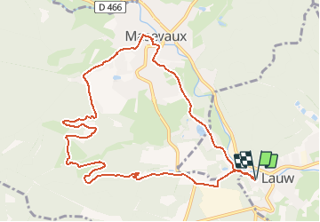
19.9 km | 34 km-effort
4h 44min
Yes
Trail Walking Sentheim - Sentheim Rossberg - Photo
Walking
helmut68

Walking

Medium
(1)
Sentheim, Grand Est, Haut-Rhin, France
27 km | 40 km-effort
6h 11min
Yes
Trail Walking Lauw - 2022-07-14 Marche Lauw Refuge CAF Baerenkopf - Photo
Walking
GUIDE
holtzv

Walking

Very difficult
Lauw, Grand Est, Haut-Rhin, France
18.4 km | 31 km-effort
5h 35min
No
Trail On foot Sentheim - Sentier géologique du Wolfloch - Photo
On foot
GUIDE+

On foot

Easy
Sentheim, Grand Est, Haut-Rhin, France
3.8 km | 4.8 km-effort
1h 5min
No
Trail On foot Sentheim - Sentheim - Bergwald - Eichwald - Guevenheim - Sentheim - Photo
On foot
patrickbeyrath

On foot

Easy
(1)
Sentheim, Grand Est, Haut-Rhin, France
13.4 km | 16.6 km-effort
Unknown
Yes
Trail Walking Masevaux-Niederbruck - Reco avec ALAIN..Rando CLAS du 29/08/2024 - Photo
Walking
boubou68

Walking

Very difficult
Masevaux-Niederbruck, Grand Est, Haut-Rhin, France
20 km | 31 km-effort
6h 2min
Yes
Trail Walking Sentheim - Randonnée Pentecôte 2024 - Photo
Walking
helmut68

Walking

Medium
Sentheim, Grand Est, Haut-Rhin, France
14.8 km | 18.3 km-effort
4h 0min
Yes
Trail Walking Masevaux-Niederbruck - Rando CLAS du 25/04/2024 - Photo
Walking
boubou68

Walking

Very difficult
Masevaux-Niederbruck, Grand Est, Haut-Rhin, France
17 km | 28 km-effort
4h 24min
Yes
Trail Walking Kirchberg - Rando du 11/04/2024  ..Marcheurs - Photo
Walking
boubou68

Walking

Very difficult
Kirchberg, Grand Est, Haut-Rhin, France
23 km | 37 km-effort
5h 37min
Yes


Close
My subscriptions