Trail On foot Saint-Maime - SAINT MAIME . Brives , le Pin Blanc o - Photo
© OpenStreetMap contributors
Length
Length
13.9 km
Max alt
Max alt
606 m
Uphill gradient
Uphill gradient
350 m
Km-Effort
Km-Effort  
18.6 km
Min alt
Min alt
384 m
Downhill gradient
Downhill gradient
349 m
Boucle
Boucle
Yes
Creation date :
2020-01-07 07:52:58.932
Updated on :
2020-01-07 17:29:24.966

(1 Reviews)

On foot
On foot
--
Difficulty : Easy
Walking
Walking
6h12
Difficulty : Very easy

Scan this QR Code to open this trail in the SityTrail application

FREE GPS app for hiking

Logo SityTrail SityTrail

IGN / Geographical institutes

Download SityTrail from the App Store Download SityTrail from Google Play

Logo SityTrail SityTrail World

The world is yours!

Download SityTrail from the App Store Download SityTrail from Google Play Download SityTrail on Huawei AppGallery

About

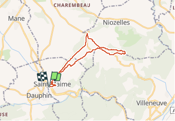
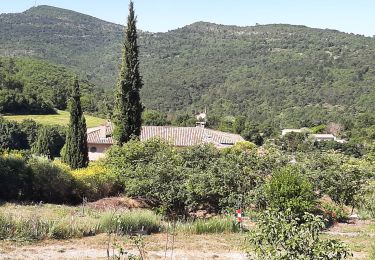
Trail On foot of 13.9 km to be discovered at Provence-Alpes-Côte d'Azur, Alpes-de-Haute-Provence, Saint-Maime. This trail is proposed by RobinMicheline.

Description

Village sympa , belle vue sommet du Pin Blanc ,  retour par sentier des cretes agreable

Elevation profile

Photos

Positioning

Country:
France
Region :
Provence-Alpes-Côte d'Azur
Department/Province :
Alpes-de-Haute-Provence
Municipality :
Saint-Maime
Location:
Unknown
Start:(UTM)
724116 ; 4864800 (31T) N.

Comments

Please log in to post a review or rate the element


Agreable facile


Trails nearby

Trail Walking Mane - 110ter-Mane.Les Ybourgues. sans passer par Chateauneuf. Mane  - Photo
Walking
dumotier

Walking

Medium
(1)
Mane, Provence-Alpes-Côte d'Azur, Alpes-de-Haute-Provence, France
13.2 km | 19.8 km-effort
3h 0min
Yes
Trail Walking Mane - MANE Tours de la laye 3 - Photo
Walking
RobinMicheline

Walking

Medium
(1)
Mane, Provence-Alpes-Côte d'Azur, Alpes-de-Haute-Provence, France
15.1 km | 22 km-effort
5h 59min
Yes
Trail Mountain bike Volx - Volx/Montaigu/Bellevue/La Garde - Photo
Mountain bike
remizzi

Mountain bike

Medium
(1)
Volx, Provence-Alpes-Côte d'Azur, Alpes-de-Haute-Provence, France
16.2 km | 24 km-effort
1h 33min
Yes
Trail Walking Mane - mane le barrage - Photo
Walking
Roger

Walking

Medium
Mane, Provence-Alpes-Côte d'Azur, Alpes-de-Haute-Provence, France
11.5 km | 16.5 km-effort
4h 42min
Yes
Trail Walking Mane - salagon 04 .mane 04 leS - Photo
Walking
Roger

Walking

Medium
Mane, Provence-Alpes-Côte d'Azur, Alpes-de-Haute-Provence, France
13.4 km | 18 km-effort
4h 37min
Yes
Trail Trail Volx - volx - Photo
Trail
francislassauce

Trail

Difficult
Volx, Provence-Alpes-Côte d'Azur, Alpes-de-Haute-Provence, France
9.2 km | 14.7 km-effort
1h 43min
Yes
Trail Walking Saint-Michel-l'Observatoire - de Saint Martin les eaux à biabaux . la chapelle de hurage - Photo
Walking
Roger

Walking

Easy
Saint-Michel-l'Observatoire, Provence-Alpes-Côte d'Azur, Alpes-de-Haute-Provence, France
9.4 km | 13.1 km-effort
2h 51min
Yes
Trail Walking Saint-Martin-les-Eaux - 1Domaine de Bourne - Photo
Walking
liocol

Walking

Medium
Saint-Martin-les-Eaux, Provence-Alpes-Côte d'Azur, Alpes-de-Haute-Provence, France
5.6 km | 8.3 km-effort
2h 2min
Yes
Trail Walking Manosque - 1Pélicier, chemin des collines, le Chateau via l'Ausselet - Photo
Walking
liocol

Walking

Easy
Manosque, Provence-Alpes-Côte d'Azur, Alpes-de-Haute-Provence, France
7.1 km | 9.7 km-effort
2h 9min
Yes


Close
My subscriptions