Trail Mountain bike Sainte-Colombe-sur-l'Hers - Ste Colombe-sur-l'Hers Léran Camon - Photo

Ste Colombe-sur-l'Hers Léran Camon

 jopost
jopost

User

© OpenStreetMap contributors
Length
Length
16.2 km
Max alt
Max alt
482 m
Uphill gradient
Uphill gradient
238 m
Km-Effort
Km-Effort  
19.6 km
Min alt
Min alt
338 m
Downhill gradient
Downhill gradient
309 m
Boucle
Boucle
No
Creation date :
2017-01-09 00:00:00.0
Updated on :
2017-01-09 00:00:00.0

(0 Reviews)

Mountain bike
Mountain bike
1h25
Difficulty : Difficult

Scan this QR Code to open this trail in the SityTrail application

FREE GPS app for hiking

Logo SityTrail SityTrail

IGN / Geographical institutes

Download SityTrail from the App Store Download SityTrail from Google Play

Logo SityTrail SityTrail World

The world is yours!

Download SityTrail from the App Store Download SityTrail from Google Play Download SityTrail on Huawei AppGallery

About

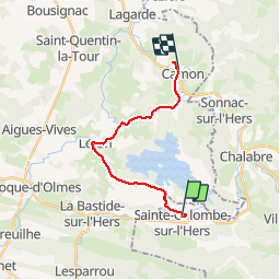
Trail Mountain bike of 16.2 km to be discovered at Occitania, Aude, Sainte-Colombe-sur-l'Hers. This trail is proposed by jopost.

Elevation profile

Photos

Positioning

Country:
France
Region :
Occitania
Department/Province :
Aude
Municipality :
Sainte-Colombe-sur-l'Hers
Location:
Unknown
Start:(UTM)
415648 ; 4756338 (31T) N.

Trails nearby

Trail Walking Rivel - Au fil de l'eau - Rivel - Photo
Walking
tracegps

Walking

Medium
(1)
Rivel, Occitania, Aude, France
5.2 km | 7 km-effort
1h 45min
Yes
Trail Walking Rivel - Le chemin du château - Rivel - Photo
Walking
tracegps

Walking

Easy
(1)
Rivel, Occitania, Aude, France
2.4 km | 4 km-effort
45min
Yes
Trail Walking Montbel - Lac de Montbel - Photo
Walking
tracegps

Walking

Medium
(2)
Montbel, Occitania, Ariège, France
15.8 km | 18.4 km-effort
3h 19min
Yes
Trail Mountain bike Léran - Lac de Montbel - Chalabre - Photo
Mountain bike
tracegps

Mountain bike

Medium
(1)
Léran, Occitania, Ariège, France
25 km | 30 km-effort
3h 0min
Yes
Trail On foot Montbel - Tour du Lac de Montbel - Photo
On foot
PRO

On foot

Easy
Montbel, Occitania, Ariège, France
15.3 km | 17.9 km-effort
4h 4min
Yes
Trail Cycle Chalabre - Chalabre - Limoux - Espéraza - Photo
Cycle
tracegps

Cycle

Difficult
Chalabre, Occitania, Aude, France
72 km | 88 km-effort
4h 30min
Yes
Trail Equestrian Chalabre - La colline du calvaire - Chalabre - Photo
Equestrian
tracegps

Equestrian

Easy
Chalabre, Occitania, Aude, France
4.4 km | 6.4 km-effort
1h 0min
Yes
Trail Walking Chalabre - La colline du calvaire - Chalabre - Photo
Walking
tracegps

Walking

Easy
Chalabre, Occitania, Aude, France
4.4 km | 6.4 km-effort
1h 30min
Yes
Trail Walking Chalabre - Circuit de découverte de Chalabre - Photo
Walking
tracegps

Walking

Easy
Chalabre, Occitania, Aude, France
3.5 km | 3.9 km-effort
1h 0min
Yes


Close
My subscriptions