Trail Walking Mont-Saint-Hilaire - 27-MAY-12 - Photo
 Alizée.pee
Alizée.pee

User GUIDE

© OpenStreetMap contributors
Length
Length
12.5 km
Max alt
Max alt
395 m
Uphill gradient
Uphill gradient
500 m
Km-Effort
Km-Effort  
19.2 km
Min alt
Min alt
125 m
Downhill gradient
Downhill gradient
498 m
Boucle
Boucle
Yes
Creation date :
2019-09-03 13:24:41.476
Updated on :
2019-09-03 13:34:22.483

(1 Reviews)

Walking
Walking
3h58
Difficulty : Medium

Scan this QR Code to open this trail in the SityTrail application

FREE GPS app for hiking

Logo SityTrail SityTrail

IGN / Geographical institutes

Download SityTrail from the App Store Download SityTrail from Google Play

Logo SityTrail SityTrail World

The world is yours!

Download SityTrail from the App Store Download SityTrail from Google Play Download SityTrail on Huawei AppGallery

About

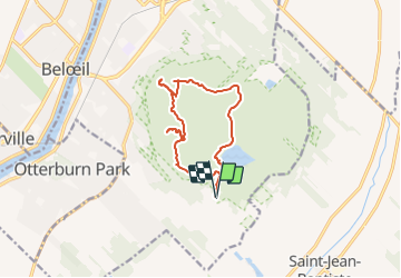
Trail Walking of 12.5 km to be discovered at Quebec, La Vallée-du-Richelieu, Mont-Saint-Hilaire. This trail is proposed by Alizée.pee.

Description

Cette montagne est assez populaire. Par temps clair, il est possible d’apercevoir à partir du sommet, le centre-ville de Montréal ainsi qu’un très beau panorama de la région. Ce mont est aussi très connu de par sa grande variété de fleurs et d’oiseaux. Pour ce rendre au sommet, j’ai emprunter le sentier Pain-de-Sucre qui est très large et bien balisé. Cette randonnée effectue une boucle des 4 sommets.

Elevation profile

Points of interest

Point of interest Mont-Saint-Hilaire - Stationnement - Photo
Alizée.pee
MONT-SAINT-HILAIRE 
Point of interest Mont-Saint-Hilaire - Sommet - Rocky - Photo
Alizée.pee
MONT-SAINT-HILAIRE 
Point of interest Mont-Saint-Hilaire - Sommet - Pain de Sucre - Photo
Alizée.pee
MONT-SAINT-HILAIRE 
Point of interest Mont-Saint-Hilaire - Sommet - Dieppe - Photo
Alizée.pee
MONT-SAINT-HILAIRE 
Point of interest Mont-Saint-Hilaire - Sommet - Burned Hill - Photo
Alizée.pee
MONT-SAINT-HILAIRE 
Point of interest Mont-Saint-Hilaire - Point de vue - Lac Hertel - Photo
Alizée.pee
MONT-SAINT-HILAIRE 
Point of interest Mont-Saint-Hilaire - Lac Hertel - Photo
Alizée.pee
MONT-SAINT-HILAIRE 
Point of interest Mont-Saint-Hilaire - Intersection 3 - Photo
Alizée.pee
MONT-SAINT-HILAIRE 
Point of interest Mont-Saint-Hilaire - Intersection 2 - Photo
Alizée.pee
MONT-SAINT-HILAIRE 
Point of interest Mont-Saint-Hilaire - Intersection 1 - Photo
Alizée.pee
MONT-SAINT-HILAIRE 
Point of interest Mont-Saint-Hilaire - Accueil - Photo
Alizée.pee
MONT-SAINT-HILAIRE 

Positioning

Country:
Canada
Region :
Quebec
Department/Province :
La Vallée-du-Richelieu
Municipality :
Mont-Saint-Hilaire
Location:
Unknown
Start:(UTM)
643861 ; 5044161 (18T) N.

Comments

Please log in to post a review or rate the element


Merci pour ce partage !


Trails nearby

Trail Walking Mont-Saint-Hilaire - Wikiloc - Mont saint hilaire - Photo
Walking
GUIDE
Alizée.pee

Walking

Difficult
Mont-Saint-Hilaire, Quebec, La Vallée-du-Richelieu, Canada
9.4 km | 13.8 km-effort
2h 53min
Yes


Close
My subscriptions