Trail Walking Mont-Albert - Wikiloc - Parc National de la Gaspésie - Sentier du Pic du brûlé via le Mont Ernest-Ménard. - Photo

Wikiloc - Parc National de la Gaspésie - Sentier du Pic du brûlé via le Mont Ernest-Ménard.

 Alizée.pee
Alizée.pee

User GUIDE

© OpenStreetMap contributors
Length
Length
13.2 km
Max alt
Max alt
838 m
Uphill gradient
Uphill gradient
531 m
Km-Effort
Km-Effort  
20 km
Min alt
Min alt
504 m
Downhill gradient
Downhill gradient
531 m
Boucle
Boucle
Yes
Creation date :
2019-08-22 12:38:05.223
Updated on :
2019-08-22 12:40:15.568

(0 Reviews)

Walking
Walking
4h12
Difficulty : Difficult

Scan this QR Code to open this trail in the SityTrail application

FREE GPS app for hiking

Logo SityTrail SityTrail

IGN / Geographical institutes

Download SityTrail from the App Store Download SityTrail from Google Play

Logo SityTrail SityTrail World

The world is yours!

Download SityTrail from the App Store Download SityTrail from Google Play Download SityTrail on Huawei AppGallery

About

Trail Walking of 13.2 km to be discovered at Quebec, La Haute-Gaspésie, Mont-Albert. This trail is proposed by Alizée.pee.

Description

Le sentier passe principalement par un milieu forestier et présente plusieurs points de vue qui offrent une magnifique vue sur les murailles des Chics-Chocs et sur la vallée du Saint-Laurent. La randonnée offre des paysages sublimes et de très beaux lacs !

Elevation profile

Positioning

Country:
Canada
Region :
Quebec
Department/Province :
La Haute-Gaspésie
Municipality :
Mont-Albert
Location:
Unknown
Start:(UTM)
696445 ; 5423618 (19U) N.

Trails nearby

Trail Walking Mont-Albert - Québec - PN de la Gaspésie - Pic du Brûlé - Photo
Walking
nicolasbarbarin

Walking

Medium
Mont-Albert, Quebec, La Haute-Gaspésie, Canada
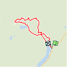
14.8 km | 22 km-effort
6h 1min
Yes


Close
My subscriptions