Trail Mountain bike Vitry-en-Montagne - th 13 08 19 - Photo
 jiam6852
jiam6852

User

© OpenStreetMap contributors
Length
Length
39 km
Max alt
Max alt
479 m
Uphill gradient
Uphill gradient
733 m
Km-Effort
Km-Effort  
49 km
Min alt
Min alt
315 m
Downhill gradient
Downhill gradient
735 m
Boucle
Boucle
Yes
Creation date :
2014-12-10 00:00:00.0
Updated on :
2014-12-10 00:00:00.0

(0 Reviews)

Mountain bike
Mountain bike
4h01
Difficulty : Difficult

Scan this QR Code to open this trail in the SityTrail application

FREE GPS app for hiking

Logo SityTrail SityTrail

IGN / Geographical institutes

Download SityTrail from the App Store Download SityTrail from Google Play

Logo SityTrail SityTrail World

The world is yours!

Download SityTrail from the App Store Download SityTrail from Google Play Download SityTrail on Huawei AppGallery

About

Trail Mountain bike of 39 km to be discovered at Grand Est, Haute-Marne, Vitry-en-Montagne. This trail is proposed by jiam6852.

Elevation profile

Points of interest

Point of interest Villars-Santenoge - Point 1 - Photo
jiam6852
VILLARS-SANTENOGE 

Positioning

Country:
France
Region :
Grand Est
Department/Province :
Haute-Marne
Municipality :
Vitry-en-Montagne
Location:
Unknown
Start:(UTM)
656447 ; 5299102 (31T) N.

Trails nearby

Trail Cycle Auberive - La Montagne - Auberive - Photo
Cycle
tracegps

Cycle

Difficult
Auberive, Grand Est, Haute-Marne, France
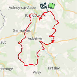
65 km | 80 km-effort
6h 0min
Yes
Trail Walking Auberive - Sentier Vosges-Pyrénées - de Auberive à Grancey le Château - Photo
Walking
tracegps

Walking

Difficult
Auberive, Grand Est, Haute-Marne, France
18.7 km | 25 km-effort
5h 0min
No
Trail Mountain bike Auberive - Le Pont Griselin - Auberive - Photo
Mountain bike
tracegps

Mountain bike

Easy
Auberive, Grand Est, Haute-Marne, France
3.3 km | 3.8 km-effort
19min
Yes
Trail Walking Auberive - Le Pont Griselin - Auberive - Photo
Walking
tracegps

Walking

Very difficult
Auberive, Grand Est, Haute-Marne, France
3.3 km | 3.8 km-effort
1h 0min
Yes
Trail Mountain bike Auberive - Circuit de Montavoir - Auberive - Photo
Mountain bike
tracegps

Mountain bike

Easy
Auberive, Grand Est, Haute-Marne, France
9.1 km | 11.3 km-effort
45min
Yes
Trail Walking Auberive - Circuit de Montavoir - Auberive - Photo
Walking
tracegps

Walking

Easy
Auberive, Grand Est, Haute-Marne, France
9.1 km | 11.3 km-effort
1h 19min
Yes
Trail Mountain bike Auberive - La Tufière d'Amorey - Auberive - Photo
Mountain bike
tracegps

Mountain bike

Easy
Auberive, Grand Est, Haute-Marne, France
10.6 km | 14.2 km-effort
1h 0min
Yes
Trail Walking Auberive - La Tufière d'Amorey - Auberive - Photo
Walking
tracegps

Walking

Easy
Auberive, Grand Est, Haute-Marne, France
10.6 km | 14.2 km-effort
2h 0min
Yes
Trail Mountain bike Bay-sur-Aube - La Butte de Taloison - Bay sur Aube - Photo
Mountain bike
tracegps

Mountain bike

Easy
Bay-sur-Aube, Grand Est, Haute-Marne, France
8 km | 11 km-effort
45min
Yes


Close
My subscriptions