Trail Walking Ventalon en Cévennes - les cretes de st amand - Photo
© OpenStreetMap contributors
Length
Length
111 km
Max alt
Max alt
753 m
Uphill gradient
Uphill gradient
4639 m
Km-Effort
Km-Effort  
174 km
Min alt
Min alt
30 m
Downhill gradient
Downhill gradient
5029 m
Boucle
Boucle
No
Creation date :
2019-05-27 09:56:23.063
Updated on :
2019-05-30 16:23:24.493

(0 Reviews)

Walking
Walking
5h57
Difficulty : Difficult

Scan this QR Code to open this trail in the SityTrail application

FREE GPS app for hiking

Logo SityTrail SityTrail

IGN / Geographical institutes

Download SityTrail from the App Store Download SityTrail from Google Play

Logo SityTrail SityTrail World

The world is yours!

Download SityTrail from the App Store Download SityTrail from Google Play Download SityTrail on Huawei AppGallery

About

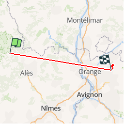
Trail Walking of 111 km to be discovered at Occitania, Lozère, Ventalon en Cévennes. This trail is proposed by nanard223.

Description

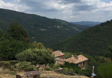
Très belle randonnée. Point de vues exceptionnels

Elevation profile

Positioning

Country:
France
Region :
Occitania
Department/Province :
Lozère
Municipality :
Ventalon en Cévennes
Location:
Saint-Frézal-de-Ventalon
Start:(UTM)
571796 ; 4903895 (31T) N.

Trails nearby

Trail Walking Vialas - Sentier de l'Avès depuis le Coupétadou - Photo
Walking
alfreson

Walking

Medium
(1)
Vialas, Occitania, Lozère, France
15.3 km | 23 km-effort
4h 51min
Yes
Trail Walking Ventalon en Cévennes - Sentier de l'Avès - Photo
Walking
GUIDE
nadinebondoux

Walking

Medium
Ventalon en Cévennes, Occitania, Lozère, France
14.7 km | 22 km-effort
4h 24min
Yes
Trail On foot Le Collet-de-Dèze - Sentier de découverte de Tignac - Photo
On foot
GUIDE+

On foot

Easy
Le Collet-de-Dèze, Occitania, Lozère, France
3.6 km | 5.8 km-effort
1h 18min
No
Trail On foot Le Collet-de-Dèze - PR Sentier de Molières - Photo
On foot
GUIDE+

On foot

Easy
Le Collet-de-Dèze, Occitania, Lozère, France
3.5 km | 4.7 km-effort
1h 4min
No
Trail Walking Ventalon en Cévennes - col de hauts de St privât. - Photo
Walking
sereton

Walking

Easy
Ventalon en Cévennes, Occitania, Lozère, France
8.6 km | 13.3 km-effort
2h 30min
Yes
Trail Walking Vialas - Sentier de l'Avès depuis le Coupétadou - Photo
Walking
alfreson

Walking

Medium
Vialas, Occitania, Lozère, France
15.3 km | 23 km-effort
4h 51min
Yes
Trail Walking Saint-Privat-de-Vallongue - 30 ravin de l’enfer 7 mai 2019 - Photo
Walking
silvestreclaudine

Walking

Very difficult
Saint-Privat-de-Vallongue, Occitania, Lozère, France
49 km | 0 m-effort
6h 59min
No
Trail Walking Vialas - Vialas et le Luech - Photo
Walking
Charles Lemaire

Walking

Medium
Vialas, Occitania, Lozère, France
8.1 km | 11.8 km-effort
2h 41min
Yes
Trail Walking Ventalon en Cévennes - Col de Banette - Photo
Walking
GUIDE
Roger Philippe Wallez

Walking

Very difficult
Ventalon en Cévennes, Occitania, Lozère, France
14 km | 21 km-effort
5h 14min
Yes


Close
My subscriptions