Trail Walking Duras - LaSauvetatduDropt - Photo
© OpenStreetMap contributors
Length
Length
9.2 km
Max alt
Max alt
128 m
Uphill gradient
Uphill gradient
130 m
Km-Effort
Km-Effort  
10.9 km
Min alt
Min alt
39 m
Downhill gradient
Downhill gradient
131 m
Boucle
Boucle
Yes
Creation date :
2019-05-20 09:01:43.143
Updated on :
2019-05-20 09:15:57.951

(0 Reviews)

Walking
Walking
2h22
Difficulty : Medium

Scan this QR Code to open this trail in the SityTrail application

FREE GPS app for hiking

Logo SityTrail SityTrail

IGN / Geographical institutes

Download SityTrail from the App Store Download SityTrail from Google Play

Logo SityTrail SityTrail World

The world is yours!

Download SityTrail from the App Store Download SityTrail from Google Play Download SityTrail on Huawei AppGallery

About

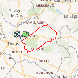
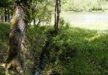
Trail Walking of 9.2 km to be discovered at New Aquitaine, Lot-et-Garonne, Duras. This trail is proposed by garigotte.

Description

rando facile

Elevation profile

Positioning

Country:
France
Region :
New Aquitaine
Department/Province :
Lot-et-Garonne
Municipality :
Duras
Location:
Unknown
Start:(UTM)
277273 ; 4951039 (31T) N.

Comments

Please log in to post a review or rate the element


Attention impossible de passer dans les champs à la sortie de Duras. Détours par grande route qui n'est pas agréable sinon parcours accessible à tous.


Trails nearby

Trail Walking Pardaillan - Saint Front - pardaillan - Photo
Walking
Briarwood

Walking

Easy
(1)
Pardaillan, New Aquitaine, Lot-et-Garonne, France
6 km | 6.9 km-effort
1h 47min
Yes
Trail Walking Baleyssagues - Balayssagues - Photo
Walking
Briarwood

Walking

Easy
Baleyssagues, New Aquitaine, Lot-et-Garonne, France
5.3 km | 6.4 km-effort
1h 34min
Yes
Trail Walking Saint-Sernin - Lubersac - Photo
Walking
Briarwood

Walking

Easy
Saint-Sernin, New Aquitaine, Lot-et-Garonne, France
5.9 km | 7.3 km-effort
1h 50min
Yes
Trail Mountain bike Duras - Ronde du Pruneau - Duras - Photo
Mountain bike
tracegps

Mountain bike

Difficult
Duras, New Aquitaine, Lot-et-Garonne, France
42 km | 51 km-effort
3h 30min
Yes
Trail Mountain bike Saint-Sernin - castel gaillard - Photo
Mountain bike
fishmamsk8

Mountain bike

Easy
Saint-Sernin, New Aquitaine, Lot-et-Garonne, France
12 km | 14.5 km-effort
1h 13min
Yes
Trail Cycle Duras - Circuit Vignes et Vergers en Duraquois - Photo
Cycle
tracegps

Cycle

Difficult
Duras, New Aquitaine, Lot-et-Garonne, France
102 km | 122 km-effort
5h 0min
Yes
Trail Mountain bike Saint-Sernin - Lubersac, une église de Saint-Sernin de Duras - Pays du Dropt - Photo
Mountain bike
tracegps

Mountain bike

Easy
Saint-Sernin, New Aquitaine, Lot-et-Garonne, France
5.4 km | 6.4 km-effort
40min
Yes
Trail Walking Saint-Sernin - Lubersac, une église de Saint-Sernin de Duras - Pays du Dropt - Photo
Walking
tracegps

Walking

Easy
Saint-Sernin, New Aquitaine, Lot-et-Garonne, France
5.4 km | 6.4 km-effort
2h 0min
Yes
Trail Walking Saint-Sernin - Saint-Sernin-de-Duras, la balade de Castelgaillard - Pays du Dropt - Photo
Walking
tracegps

Walking

Easy
Saint-Sernin, New Aquitaine, Lot-et-Garonne, France
4.4 km | 5.1 km-effort
1h 30min
Yes


Close
My subscriptions