Trail Moto cross Saint-Chély-d'Apcher - saint-chely saint martin - Photo

saint-chely saint martin

 frank12
frank12

User

© OpenStreetMap contributors
Length
Length
102 km
Max alt
Max alt
1394 m
Uphill gradient
Uphill gradient
2621 m
Km-Effort
Km-Effort  
138 km
Min alt
Min alt
425 m
Downhill gradient
Downhill gradient
2994 m
Boucle
Boucle
No
Creation date :
2019-05-05 10:01:35.252
Updated on :
2019-05-05 10:05:51.743

(1 Reviews)

Moto cross
Moto cross
4h00
Difficulty : Easy

Scan this QR Code to open this trail in the SityTrail application

FREE GPS app for hiking

Logo SityTrail SityTrail

IGN / Geographical institutes

Download SityTrail from the App Store Download SityTrail from Google Play

Logo SityTrail SityTrail World

The world is yours!

Download SityTrail from the App Store Download SityTrail from Google Play Download SityTrail on Huawei AppGallery

About

Trail Moto cross of 102 km to be discovered at Occitania, Lozère, Saint-Chély-d'Apcher. This trail is proposed by frank12.

Elevation profile

Positioning

Country:
France
Region :
Occitania
Department/Province :
Lozère
Municipality :
Saint-Chély-d'Apcher
Location:
Unknown
Start:(UTM)
521815 ; 4960552 (31T) N.

Comments

Please log in to post a review or rate the element


Bonjour, je viens de voir votre rando et j'aimerai savoir avec quel type de moto vous l'avez faite ? Pour ma par j'ai une Africa Twin 1000CRF. Pensez vous que cette rando et les autres que vous avez publiées sont faisables avec mon trail ? Merci de votre réponse


Trails nearby

Trail Walking Saint-Chély-d'Apcher - De St Chely d'Apcher à Aumont  Aubrac - Photo
Walking
tracegps

Walking

Difficult
Saint-Chély-d'Apcher, Occitania, Lozère, France
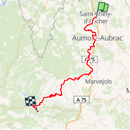
18.6 km | 24 km-effort
4h 15min
No
Trail Moto cross Saint-Chély-d'Apcher - saint-chely vimenet - Photo
Moto cross
frank12

Moto cross

Easy
Saint-Chély-d'Apcher, Occitania, Lozère, France
109 km | 149 km-effort
Unknown
No
Trail Walking Saint-Chély-d'Apcher - Aubrac - 2° jour St Chély d'Apcher - Aumont Aubrac - Photo
Walking
jmp76700

Walking

Medium
Saint-Chély-d'Apcher, Occitania, Lozère, France
18.1 km | 24 km-effort
5h 9min
No
Trail Motor Les Bessons - Parcours quad 02 - Photo
Motor
splanc

Motor

Difficult
Les Bessons, Occitania, Lozère, France
17.5 km | 22 km-effort
56min
Yes
Trail Motor Les Bessons - Tour QUAD 001 - Photo
Motor
splanc

Motor

Medium
Les Bessons, Occitania, Lozère, France
16.2 km | 21 km-effort
Unknown
Yes
Trail Walking Prunières - SityTrail - Apcher  la Tuyère - Photo
Walking
raymondfn

Walking

Difficult
Prunières, Occitania, Lozère, France
11.6 km | 15.3 km-effort
3h 28min
Yes
Trail Mountain bike Saint-Chély-d'Apcher - St chely d'apcher siniere  - Photo
Mountain bike
yvesdpt38

Mountain bike

Very difficult
Saint-Chély-d'Apcher, Occitania, Lozère, France
38 km | 49 km-effort
3h 22min
No
Trail Electric bike Saint-Chély-d'Apcher - 3_250423 - Photo
Electric bike
ricou1964

Electric bike

Difficult
Saint-Chély-d'Apcher, Occitania, Lozère, France
40 km | 52 km-effort
5h 22min
No
Trail Road bike Saint-Chély-d'Apcher - 14- St Chély d'Apcher - Mende - Photo
Road bike
v.hanosset

Road bike

Very difficult
Saint-Chély-d'Apcher, Occitania, Lozère, France
49 km | 61 km-effort
3h 42min
No


Close
My subscriptions