Trail Mountain bike Sainte-Radegonde - Combelles et les Crêtes - Photo

Combelles et les Crêtes

 tracegps
tracegps

User

© OpenStreetMap contributors
Length
Length
19.7 km
Max alt
Max alt
809 m
Uphill gradient
Uphill gradient
502 m
Km-Effort
Km-Effort  
26 km
Min alt
Min alt
591 m
Downhill gradient
Downhill gradient
507 m
Boucle
Boucle
Yes
Creation date :
2014-12-10 00:00:00.0
Updated on :
2014-12-10 00:00:00.0

(0 Reviews)

Mountain bike
Mountain bike
3h04
Difficulty : Difficult

Scan this QR Code to open this trail in the SityTrail application

FREE GPS app for hiking

Logo SityTrail SityTrail

IGN / Geographical institutes

Download SityTrail from the App Store Download SityTrail from Google Play

Logo SityTrail SityTrail World

The world is yours!

Download SityTrail from the App Store Download SityTrail from Google Play Download SityTrail on Huawei AppGallery

About

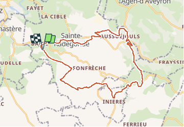
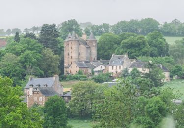
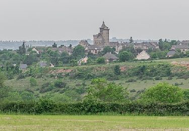
Trail Mountain bike of 19.7 km to be discovered at Occitania, Aveyron, Sainte-Radegonde. This trail is proposed by tracegps.

Description

Une boucle avec des descentes assez techniques. Pour finir vous pouvez allez dans les bois, attention plusieurs possibilités et les branches sont basses ! Bonne balade! Pour plus de photo voici un Lien .

Elevation profile

Photos

Positioning

Country:
France
Region :
Occitania
Department/Province :
Aveyron
Municipality :
Sainte-Radegonde
Location:
Unknown
Start:(UTM)
468691 ; 4908849 (31T) N.

Trails nearby

Trail On foot Rodez - Randonnée de Rodez Agglomération Circuit n°2 - Layoule - Photo
On foot
GUIDE+

On foot

Easy
Rodez, Occitania, Aveyron, France
5.6 km | 6.6 km-effort
1h 29min
Yes
Trail On foot Onet-le-Château - Circuit 16 Moulin de cantarane - Photo
On foot
GUIDE+

On foot

Easy
Onet-le-Château, Occitania, Aveyron, France
6.3 km | 8 km-effort
1h 48min
Yes
Trail On foot Sainte-Radegonde - Circuit 15 Inières - Photo
On foot
GUIDE+

On foot

Easy
Sainte-Radegonde, Occitania, Aveyron, France
5.6 km | 8.2 km-effort
1h 51min
Yes
Trail On foot Sainte-Radegonde - Circuit 14 Sainte-Radegonde - Photo
On foot
GUIDE+

On foot

Easy
Sainte-Radegonde, Occitania, Aveyron, France
12.2 km | 16.2 km-effort
3h 40min
Yes
Trail On foot Le Monastère - Circuit 11 Le Monsastère - Photo
On foot
GUIDE+

On foot

Easy
Le Monastère, Occitania, Aveyron, France
6.4 km | 7.9 km-effort
1h 47min
No
Trail On foot Luc-la-Primaube - Circuit 10 La Capelle Saint-Martin - Photo
On foot
GUIDE+

On foot

Easy
Luc-la-Primaube, Occitania, Aveyron, France
9.6 km | 11.8 km-effort
2h 40min
No
Trail On foot Olemps - Circuit 8 Le Viel Olemps - Photo
On foot
GUIDE+

On foot

Easy
Olemps, Occitania, Aveyron, France
5.1 km | 6.5 km-effort
1h 29min
Yes
Trail On foot Rodez - Via Piodensis - Rodez - Photo
On foot
GUIDE+

On foot

Very difficult
Rodez, Occitania, Aveyron, France
113 km | 150 km-effort
34h 12min
No
Trail On foot Sainte-Radegonde - Sainte-Radegonde - Photo
On foot
GUIDE+

On foot

Easy
Sainte-Radegonde, Occitania, Aveyron, France
9.9 km | 13.2 km-effort
2h 59min
Yes


Close
My subscriptions